مقاطعة ستيرلنغ، تكساس
Sterling County | |
|---|---|
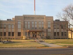
 Sterling County Court House off U.S. Highway 87 in Sterling City | |
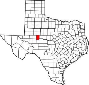
 الموقع ضمن ولاية Texas | |
 موقع Texas ضمن الولايات المتحدة | |
| الإحداثيات: خطأ لوا في وحدة:Coordinates على السطر 612: bad argument #1 to 'sub' (string expected, got nil). | |
| البلد | |
| State | |
| تأسست | 1891 |
| السمِيْ | W. S. Sterling, an early settler |
| Seat | Sterling City |
| Largest city | Sterling City |
| المساحة | |
| • الإجمالي | 924 ميل² (2٬390 كم²) |
| • البر | 923 ميل² (2٬390 كم²) |
| • الماء | 0٫1 ميل² (0٫3 كم²) 0.01% |
| التعداد (2020) | |
| • الإجمالي | 1٬372 |
| • الكثافة | 1٫5/sq mi (0٫57/km2) |
| منطقة التوقيت | UTC−6 (Central) |
| • الصيف (التوقيت الصيفي) | UTC−5 (CDT) |
| Congressional district | 11th |
| الموقع الإلكتروني | www |
مقاطعة ستيرلنغ إنگليزية: Sterling County هي إحدى المقاطعات في ولاية تكساس، الولايات المتحدة. As of the 2020 census, its population was 1,372,[1] making it the ninth-least populous county in Texas. Its county seat is Sterling City.[2] The county is named for W. S. Sterling, an early settler in the area. Sterling County was one of 30 prohibition, or entirely dry, counties in the state of Texas, but is now a moist county.[3]
. . . . . . . . . . . . . . . . . . . . . . . . . . . . . . . . . . . . . . . . . . . . . . . . . . . . . . . . . . . . . . . . . . . . . . . . . . . . . . . . . . . . . . . . . . . . . . . . . . . . . . . . . . . . . . . . . . . . . . . . . . . . . . . . . . . . . . . . . . . . . . . . . . . . . . . . . . . . . . . . . . . . . . . .
Communities
- Broome
- Sterling City (county seat)
Politics
| السنة | الجمهوري | الديمقراطي | حزب ثالث | |||
|---|---|---|---|---|---|---|
| رقم. | % | رقم. | % | رقم. | % | |
| 2020 | 584 | 91٫39% | 51 | 7٫98% | 4 | 0٫63% |
| 2016 | 549 | 86٫73% | 70 | 11٫06% | 14 | 2٫21% |
| 2012 | 459 | 92٫91% | 31 | 6٫28% | 4 | 0٫81% |
| 2008 | 520 | 84٫01% | 97 | 15٫67% | 2 | 0٫32% |
| 2004 | 544 | 88٫46% | 71 | 11٫54% | 0 | 0�00% |
| 2000 | 520 | 78٫91% | 132 | 20٫03% | 7 | 1٫06% |
| 1996 | 394 | 58٫89% | 186 | 27٫80% | 89 | 13٫30% |
| 1992 | 322 | 50٫79% | 127 | 20٫03% | 185 | 29٫18% |
| 1988 | 464 | 70٫73% | 188 | 28٫66% | 4 | 0٫61% |
| 1984 | 577 | 81٫27% | 129 | 18٫17% | 4 | 0٫56% |
| 1980 | 364 | 62٫12% | 218 | 37٫20% | 4 | 0٫68% |
| 1976 | 202 | 53٫02% | 174 | 45٫67% | 5 | 1٫31% |
| 1972 | 286 | 74٫67% | 94 | 24٫54% | 3 | 0٫78% |
| 1968 | 170 | 45٫33% | 151 | 40٫27% | 54 | 14٫40% |
| 1964 | 140 | 36٫46% | 243 | 63٫28% | 1 | 0٫26% |
| 1960 | 182 | 48٫53% | 193 | 51٫47% | 0 | 0�00% |
| 1956 | 223 | 59٫79% | 150 | 40٫21% | 0 | 0�00% |
| 1952 | 277 | 63٫68% | 158 | 36٫32% | 0 | 0�00% |
| 1948 | 17 | 6٫34% | 244 | 91٫04% | 7 | 2٫61% |
| 1944 | 18 | 5٫03% | 330 | 92٫18% | 10 | 2٫79% |
| 1940 | 16 | 3٫63% | 425 | 96٫37% | 0 | 0�00% |
| 1936 | 14 | 3٫52% | 384 | 96٫48% | 0 | 0�00% |
| 1932 | 13 | 3٫54% | 354 | 96٫46% | 0 | 0�00% |
| 1928 | 122 | 42٫21% | 167 | 57٫79% | 0 | 0�00% |
| 1924 | 25 | 9٫29% | 243 | 90٫33% | 1 | 0٫37% |
| 1920 | 17 | 9٫14% | 152 | 81٫72% | 17 | 9٫14% |
| 1916 | 6 | 2٫83% | 205 | 96٫70% | 1 | 0٫47% |
| 1912 | 4 | 2٫22% | 165 | 91٫67% | 11 | 6٫11% |
See also
References
- ^ "Sterling County, Texas". United States Census Bureau. Retrieved February 23, 2021.
- ^ "Find a County". National Association of Counties. Retrieved 2011-06-07.
- ^ "Wet/Dry Status of Texas Counties". Texas Alcoholic Beverage Commission. Retrieved July 27, 2018.
- ^ Leip, David. "Dave Leip's Atlas of U.S. Presidential Elections". uselectionatlas.org. Retrieved 2018-07-30.
External links
- Pages using gadget WikiMiniAtlas
- Short description is different from Wikidata
- مقاطعات Texas
- Articles containing إنگليزية-language text
- Pages using Lang-xx templates
- Pages with empty portal template
- Coordinates on Wikidata
- Sterling County, Texas
- 1891 establishments in Texas
- Populated places established in 1891
- مقاطعات ولاية تكساس الأمريكية
