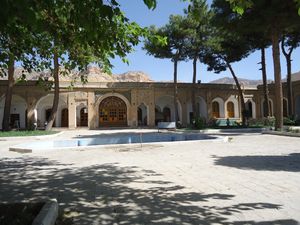
محافظة إيلام
(تم التحويل من محافظة ايلام)
Ilam Province
استان ایلام | |
|---|---|
| أصل الاسم: The ancient pre-Iranic civilization of Elam | |
| الكنية: عروس زاگرس (The Bride of Zagros) | |
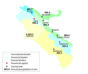
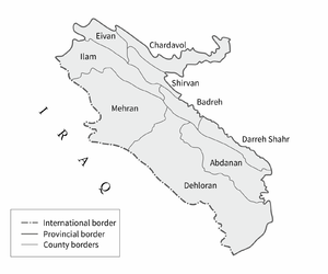
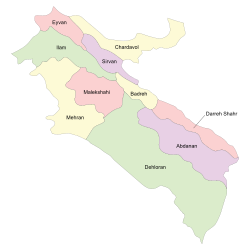 Counties of Ilam Province | |
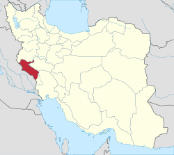 Location of Ilam Province in Iran | |
| الإحداثيات: 33°38′18″N 46°25′21″E / 33.6384°N 46.4226°E | |
| Country | |
| Region | Region 4 |
| Founded | 1973[1] |
| Capital | Ilam |
| Counties | |
| الحكومة | |
| • الكيان | Provincial Government |
| • Governor | Qasem Soleimani Dashtaki |
| المساحة | |
| • الإجمالي | 19٬086 كم² (7٬369 ميل²) |
| [2] | |
| أعلى منسوب [3] (Kan Seifi Peak) | 3٬050 m (10٬010 ft) |
| أوطى منسوب | 36 m (118 ft) |
| التعداد (2011)[5] | |
| • الإجمالي | 557٬599 |
| • الكثافة | 29/km2 (76/sq mi) |
| منطقة التوقيت | UTC+03:30 (IRST) |
| • الصيف (التوقيت الصيفي) | UTC+04:30 (IRST) |
| Postal code | 69311–69991[6] |
| مفتاح الهاتف | +98 84 |
| لوحة السيارة | Iran 98[7] |
| HDI (2017) | 0.815[8] very high · 8th |
| الموقع الإلكتروني | Ilam Portal |
إيلام هي إحدى محافظات إيران الإحدى وثلاثين.
. . . . . . . . . . . . . . . . . . . . . . . . . . . . . . . . . . . . . . . . . . . . . . . . . . . . . . . . . . . . . . . . . . . . . . . . . . . . . . . . . . . . . . . . . . . . . . . . . . . . . . . . . . . . . . . . . . . . . . . . . . . . . . . . . . . . . . . . . . . . . . . . . . . . . . . . . . . . . . . . . . . . . . . .
المراكز
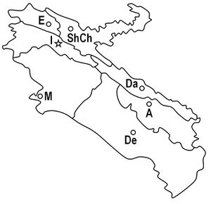
| الخريطة | الاختصارات في الخريطة | المركز (شهرستان) |
|---|---|---|
| A | مركز آبدانان | |
| Da | مركز درهشهر | |
| De | مركز دهلران | |
| E | مركز ایوان | |
| I | مركز إيلام | |
| M | مركز مهران | |
| ShCh | مركز شیروان و چرداول |
انظر القديمة
الجغرافيا
مرتفعات بارزة
الانهار
المناخ
الحكومة
التقسيمات الادارية
الشعب والثقافة
التاريخ
إيلام اليوم
الكليات والجامعات
المعالم الرئيسية
مشاهير المحافظة
المصادر
- ^ تاریخچه استان ایلام. تبیان (in Persian). موسسه فرهنگی و اطلاع رسانی تبیان. 14 January 2004. Retrieved 18 September 2015.
{{cite web}}: CS1 maint: unrecognized language (link) - ^ اقلیم استان ایلام. پورتال سازمان هواشناسی کشور (in Persian). سازمان هواشناسی کشور. Retrieved 17 September 2015.
{{cite web}}: CS1 maint: unrecognized language (link) - ^ قله "کان صیفی" ایلام در هوای برفی فتح شد (in Persian). Ilam Press. Ilam Press. January 10, 2015. Retrieved 17 September 2015.
{{cite news}}: CS1 maint: unrecognized language (link) - ^ Google Earth Pro V 7.1.5.1557. Mehran County, Iran. 32° 58’ 53.80”N, 46° 05’ 47.61”E, Eye alt 1760 meters: US Dept of State Geographer. Google 2015. Cnes/Spot Image 2015. December 22, 2002. Archived from the original on September 8, 2010. Retrieved September 18, 2015.
{{cite book}}: Unknown parameter|deadurl=ignored (|url-status=suggested) (help)CS1 maint: location (link) - ^ Selected Findings of National Population and Housing Census 2011 Archived 2013-05-31 at the Wayback Machine
- ^ کدپستی ۵ رقمی مناطق استان ایلام. سامانه پیامک برتر (in Persian). سامانه پیامک برتر. Archived from the original on 31 August 2015. Retrieved 18 September 2015.
{{cite web}}: Unknown parameter|deadurl=ignored (|url-status=suggested) (help)CS1 maint: unrecognized language (link) - ^ راهنمای کامل شماره پلاک خودرو به تفکیک شهر و استان. Setareh (in Persian). مجله اینترنتی ستاره. May 17, 2015. Retrieved 17 September 2015.
{{cite web}}: CS1 maint: unrecognized language (link) - ^ "Sub-national HDI - Area Database - Global Data Lab". hdi.globaldatalab.org (in الإنجليزية). Retrieved 2018-09-13.
. . . . . . . . . . . . . . . . . . . . . . . . . . . . . . . . . . . . . . . . . . . . . . . . . . . . . . . . . . . . . . . . . . . . . . . . . . . . . . . . . . . . . . . . . . . . . . . . . . . . . . . . . . . . . . . . . . . . . . . . . . . . . . . . . . . . . . . . . . . . . . . . . . . . . . . . . . . . . . . . . . . . . . . .
وصلات خارجية
- (فارسي) Ilam Province Department of Education
- (فارسي) Ilam Picture Gallery
الكلمات الدالة:
تصنيفات:
- Pages using gadget WikiMiniAtlas
- CS1 uses الفارسية-language script (fa)
- CS1 errors: unsupported parameter
- CS1 maint: location
- Short description is different from Wikidata
- Articles containing فارسية-language text
- Articles containing إنگليزية-language text
- Coordinates on Wikidata
- جغرافيا كردستان
- كردستان إيران
- عيلام
- محافظات إيران
