له
لـِه
གླེ་ | |
|---|---|
مدينة | |
 | |
| الإحداثيات: 34°08′43.43″N 77°34′03.41″E / 34.1453972°N 77.5676139°E | |
| البلد | الهند |
| State | جامو وكشمير |
| الضلع | له |
| المساحة | |
| • الإجمالي | 45٬110 كم² (17٬420 ميل²) |
| المنسوب | 3٬500 m (11٬500 ft) |
| التعداد (2001) | |
| • الإجمالي | 27٬513 |
| • الكثافة | 0٫61/km2 (1٫6/sq mi) |
| Languages | |
| منطقة التوقيت | UTC+5:30 (IST) |
| الموقع الإلكتروني | www |
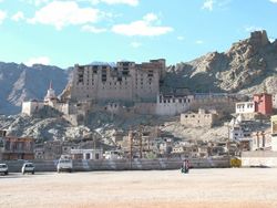
لـِه (Leh وتُنطق: leɪ، النطق (الأبجدية التبتية: གླེ་, وايلي: Gle)، كانت عاصمة مملكة لداخ في جبال الهيمالايا، والآن عاصمة ضلع له في ولاية جامو وكشمير، الهند. له، بمساحة 45,110 كم2، هي ثاني أكبر مقاطعة في الهند (بعد كوتش، گجرات) من حيث المساحة.
البلدة مازال يهيمن عليها أطلال قصر له، المقر السابق للأسرة الملكية للداخ، والذي بُني على نفس طراز وفي نفس وقت قصر پوتالا. وتقع له على ارتفاع 3,524 متر، ويربطها الطريق الوطني 1D بمدينة سرينگر إلى الجنوب الغربي. وترتبط ببلدة منالي في الجنوب بطريق له-منالي
المناخ
| بيانات المناخ لـ له | |||||||||||||
|---|---|---|---|---|---|---|---|---|---|---|---|---|---|
| الشهر | ينا | فب | مار | أبر | ماي | يون | يول | أغس | سبت | أكت | نوف | ديس | السنة |
| القصوى القياسية °س (°ف) | 8 (46) |
12 (54) |
19 (66) |
23 (73) |
28 (82) |
29 (84) |
33 (91) |
32 (90) |
31 (88) |
30 (86) |
20 (68) |
13 (55) |
33 (91) |
| متوسط القصوى اليومية °س (°ف) | −2 (28) |
1 (34) |
6 (43) |
12 (54) |
16 (61) |
21 (70) |
25 (77) |
25 (77) |
21 (70) |
14 (57) |
7 (45) |
2 (36) |
12.3 (54.1) |
| متوسط الدنيا اليومية °س (°ف) | −14 (7) |
−11 (12) |
−5 (23) |
−1 (30) |
3 (37) |
7 (45) |
10 (50) |
10 (50) |
5 (41) |
−1 (30) |
−6 (21) |
−11 (12) |
1.2 (34.2) |
| الصغرى القياسية °س (°ف) | −28 (−18) |
−25 (−13) |
−19 (−2) |
−12 (10) |
−7 (19) |
−1 (30) |
0 (32) |
−3 (27) |
−6 (21) |
−12 (10) |
−20 (−4) |
−25 (−13) |
−28 (−18) |
| متوسط تساقط الأمطار mm (inches) | 9 (0.4) |
8 (0.3) |
11 (0.4) |
9 (0.4) |
9 (0.4) |
3 (0.1) |
15 (0.6) |
15 (0.6) |
9 (0.4) |
7 (0.3) |
3 (0.1) |
4 (0.2) |
102 (4.0) |
| Source: [1] | |||||||||||||
السكان

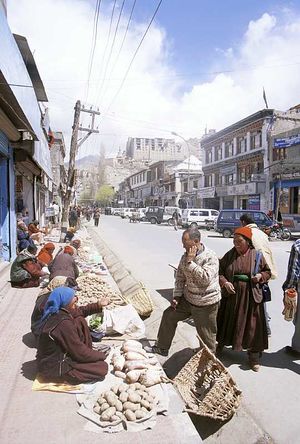
السوق في له
انظر أيضاً
الهامش
- ^ "Leh weather averages". IMD. June 2011. Retrieved 2 August 2010.
انظر أيضاً
المراجع
- Janet Rizvi. Ladakh: Crossroads of High Asia. Second Edition. (1996). Oxford University Press, Delhi. ISBN 0-19-564546-4.
- Cunningham, Alexander. (1854). LADĀK: Physical, Statistical, and Historical with Notices of the Surrounding Countries. London. Reprint: Sagar Publications (1977).
- Francke, A. H. (1977). A History of Ladakh. (Originally published as, A History of Western Tibet, (1907)). 1977 Edition with critical introduction and annotations by S. S. Gergan & F. M. Hassnain. Sterling Publishers, New Delhi.
- Francke, A. H. (1914). Antiquities of Indian Tibet. Two Volumes. Calcutta. 1972 reprint: S. Chand, New Delhi.
- Hilary Keating (July/August 1993). "The Road to Leh". Saudi Aramco World. Houston, Texas: مجلة أرامكو. 44 (4): 8–17. ISSN 1530-5821. Retrieved 2009-06-29.
{{cite journal}}: Check date values in:|date=(help) - Hill, John E. (2009). Through the Jade Gate to Rome: A Study of the Silk Routes during the Later Han Dynasty, 1st to 2nd Centuries CE. BookSurge, Charleston, South Carolina. ISBN 978-1-4392-2134-1.
للاستزادة
- Lonely Planet: Trekking in the Himalayas (Walking Guides)
وصلات خارجية
Wikivoyage has a travel guide for Leh.
All content in this article is created by Marefa contributors and is © Marefa. All rights reserved.

