كاتماندو
كاتماندو
काठमाडौँ Kathmandu | |
|---|---|
| الشعار: نـِپالي: मेरो पौरख, मेरो गौरव, मेरो काठमाण्डौ | |
 | |
| الإحداثيات: 27°43′02″N 85°19′26″E / 27.7172°N 85.3240°E | |
| البلد | |
| Development Region | Central |
| Zone | Bagmati Zone |
| District | Kathmandu District |
| Established | 723 [1] |
| الحكومة | |
| • Mayor | (none at the moment) |
| المساحة | |
| • العاصمة | 50٫67 كم² (19٫56 ميل²) |
| المنسوب | 1٬400 m (4٬600 ft) |
| التعداد | |
| • العاصمة | 949٬486 |
| • العمرانية | 1٬687٬102 |
| منطقة التوقيت | GMT +5:45 |
| الموقع الإلكتروني | http://www.kathmandu.gov.np/ |
كاتماندو ( /ˌkætmænˈduː/;,[4] (Nepal Bhasa: येँ), officially the Kathmandu Metropolitan City (نـِپالي: काठमाडौं महानगरपालिका) هي عاصمة نيپال وأكبر مدنها تقع في وادي يحمل نفس الاسم في وسط البلاد بالقرب من نهر بشنوماتي. with 845,767 inhabitants living in 105,649 households in 2021[5] and 2.9 million people in its urban agglomeration. It is located in the Kathmandu Valley, a large valley in the high plateaus in central Nepal, at an altitude of 1,400 metres (4,600 feet). It is the second largest city proper in Himalayan hill region after Srinagar, and the largest Metropolitan region in the Himalayan hill region.
The city is one of the oldest continuously inhabited places in the world, founded in 2nd century CE. The valley was historically called the "Nepal Mandala" and has been the home of the Newar people, a cosmopolitan urban civilization in the Himalayan foothills. The city was the royal capital of the Kingdom of Nepal and hosts palaces, mansions, and gardens of the Nepalese aristocracy. It has been home to the headquarters of the South Asian Association for Regional Cooperation (SAARC) since 1985. Today, it is the seat of government of the Nepalese republic, established in 2008, and is part of the Bagmati Province.
Kathmandu is and has been for many years the centre of Nepal's history, art, culture, and economy. It has a multi-ethnic population within a Hindu and Buddhist majority. Religious and cultural festivities form a major part of the lives of people residing in Kathmandu. Tourism is an important part of the economy in the city. In 2013, Kathmandu was ranked third among the top ten upcoming travel destinations in the world by TripAdvisor, and ranked first in Asia. The city is considered the gateway to the Nepalese Himalayas and is home to several World Heritage Sites: the Durbar Square, Swayambhunath, Boudhanath and Pashupatinath. Kathmandu valley is growing at 4 percent per year according to the World Bank in 2010, making it one of the fastest-growing metropolitan areas in South Asia, and the first region in Nepal to face the unprecedented challenges of rapid urbanization and modernization at a metropolitan scale.[6]
Historic areas of Kathmandu were severely damaged by a 7.8 magnitude earthquake in April 2015. Some of the buildings have been restored while some remain in the process of reconstruction.
لايعرف المؤرخون متى أُنشئت كاتماندو، ولكن المنطقة قد سُكِنت منذ ما لا يقل عن 2,600 سنة. في عام 1768م، غزت مملكة جورخا المجاورة كاتماندو، ووحدت الإقليم الذي صار فيما بعد مملكة نيبال الحديثة. يعيش في كاتماندو اليوم خليط من مجموعات عرقية مختلفة. وأغلب سكان المدينة من الهندوس، ولكن هناك الكثير من البوذيين.
أصل الاسم
The indigenous Nepal Bhasa term for Kathmandu is Yen. The Nepali name Kathmandu comes from Kasthamandap, which stood in the Durbar Square. In Sanskrit, Kāṣṭha (بالسنسكريتية: काष्ठ) means "wood" and Maṇḍapa (بالسنسكريتية: मण्डप) means "pavilion". This public pavilion, also known as Maru Satta in Newari, was rebuilt in 1596 by Biseth in the period of King Laxmi Narsingh Malla. The three-storey structure was made entirely of wood and used no iron nails nor supports. According to legends, all the timber used to build the pagoda was obtained from a single tree.[7] The structure collapsed during a major earthquake in April 2015.
The colophons of ancient manuscripts, dated as late as the 20th century, refer to Kathmandu as Kāṣṭhamaṇḍap Mahānagar in Nepal Mandala. Mahānagar means "great city". The city is called Kāṣṭhamaṇḍap in a vow that Buddhist priests still recite to this day. Thus, Kathmandu is also known as Kāṣṭhamaṇḍap. During medieval times, the city was sometimes called Kāntipur (بالسنسكريتية: कान्तिपुर). This name is derived from two Sanskrit words – Kānti and Pur. Kānti is a word that stands for "beauty" and is mostly associated with light and Pur means place, thus giving it the meaning, "City of light".
Among the indigenous Newar people, Kathmandu is known as Yeṃ Deśa (Newar: येँ देश), and Patan and Bhaktapur are known as Yala Deśa (Newar: यल देश) and Khwopa Deśa (Newar: ख्वप देश) respectively.[8] "Yen" is the shorter form of Yambu (Newar: यम्बु), which originally referred to the northern half of Kathmandu. The older northern settlements were referred to as Yambi while the southern settlement was known as Yangala.[9][10]
The spelling "Katmandu" was often used in older English-language text. More recently, however, the spelling "Kathmandu" has become more common in English.[11]
التاريخ
مملكة ليتشاڤي (400-750)
التاريخ المعاصر (1846 - 1999)
التاريخ الحديث (2000-الحاضر)

الجغرافيا

الطقس
| أخفمتوسطات الطقس لكاتمندو | |||||||||||||
|---|---|---|---|---|---|---|---|---|---|---|---|---|---|
| شهر | يناير | فبراير | مارس | أبريل | مايو | يونيو | يوليو | أغسطس | سبتمبر | اكتوبر | نوفمبر | ديسمبر | السنة |
| متوسط العظمى °م (°ف) | 18.0 (64) | 20.2 (68) | 24.3 (76) | 27.4 (81) | 28.2 (83) | 28.3 (83) | 27.7 (82) | 28.0 (82) | 27.2 (81) | 25.8 (78) | 22.7 (73) | 19.4 (67) | 24٫8 (77) |
| متوسط الصغرى °م (°ف) | 2.1 (36) | 3.8 (39) | 7.5 (46) | 11.3 (52) | 15.5 (60) | 19.0 (66) | 20.0 (68) | 19.7 (67) | 18.2 (65) | 13.0 (55) | 7.4 (45) | 3.0 (37) | 11٫7 (53) |
| هطول الأمطار mm (بوصة) | 14.2 (0.6) | 16.7 (0.7) | 31.2 (1.2) | 54.4 (2.1) | 114.2 (4.5) | 256.4 (10.1) | 359.6 (14.2) | 314.2 (12.4) | 183.1 (7.2) | 59.4 (2.3) | 7.5 (0.3) | 14.2 (0.6) | 1٬425٫1 (56٫1) |
| المصدر: World Meteorological Organisation (UN) [12] 2010-05-01 | |||||||||||||
الديمغرافيا
العمارة وأفق المدينة
قالب:Kathmandu valley World Heritage Site (WHS) Monuments
الثقافة
الفنون
الديانات
ديانة الأغلبية هي الهندوسية تليها البوذية ,
الإسلام
 مقالة مفصلة: الإسلام في نيبال
أقرب بلد إسلامي هي بنجلاديش ويتكلمون تقريبا نفس اللغات
Islam is practised in Kathmandu but Muslims are a minority, accounting for about 4.2% of the population of Nepal.[13]
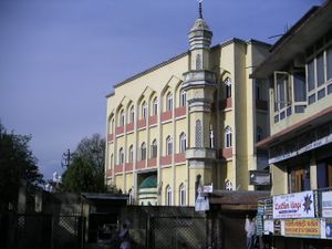
In 2004, the largest mosque in Kathmandu, Jama Masjid Mosque, was set ablaze by some 4000 people, and pulled furniture and electrical equipment out of the mosque and torched them on the sidewalk. It was a response to the killing of 12 Nepalese jobseekers in Iraq. The mosque was burned and more than a dozen private employment agencies vandalised who the protesters blamed for the loss of Nepalese citizens in the Iraq war.[14]
المدن الشقيقة
 Pyongyang, North Korea[15]
 Matsumoto, Nagano, Japan
 Rochester, New York, USA
 Eugene, Oregon, USA
 Yangon, Burma
 Xi'an, China
 Minsk, Belarus
الهامش
- ^ "Census Nepal 2001". Retrieved 13 July 2007.
- ^ World-Gazetteer
- ^ World-Gazetteer
- ^ "Definition of Kathmandu in English". Oxford Dictionaries. Archived from the original on 26 September 2015. Retrieved 25 September 2015.
- ^ "Archived copy" (PDF). cbs.gov.np. Archived from the original (PDF) on 6 February 2022. Retrieved 22 February 2022.
{{cite web}}: CS1 maint: archived copy as title (link) - ^ "Managing Nepal's Urban Transition" (in الإنجليزية). World Bank. Archived from the original on 2 November 2019. Retrieved 1 December 2019.
- ^ "Introduction". Kathmandu Metropolitan City, Government of Nepal. Archived from the original on 24 July 2011. Retrieved 12 December 2009.
- ^ Kirkpatrick, Colonel (1811). An Account of the Kingdom of Nepaul. London: William Miller. p. 159. Retrieved 9 March 2012. pp. 162–63
- ^ Tenzin, Sunam G., ed. (2001). City Diagnostic Report for City Development Strategy: Kathmandu (PDF). Kathmandu. p. 5. Archived (PDF) from the original on 17 July 2019. Retrieved 17 July 2019.
{{cite book}}: CS1 maint: location missing publisher (link) - ^ Malla, Kamal P. (December 1983). "The Limits of Surface Archaeology" (PDF). CNAS Journal. Tribhuvan University. 11 (1). Archived (PDF) from the original on 27 March 2014. Retrieved 28 July 2012.
- ^ Corbett, Philip (5 May 2015). "Behind the Dateline: 'Kathmandu' Becomes Times Style". Times Insider. The New York Times. Archived from the original on 18 April 2019. Retrieved 16 June 2019.
- ^ "World Weather Information Service - Kathmandu". UN. Retrieved 2010-05-01.
- ^ "Nepal in Figures 2006" (PDF). Government of Nepal. Retrieved 2009-12-18.
- ^ "Kathmandu mosque ablaze after hostage killings". The Sydney Morning Herald. 2004-09-01. Retrieved 2009-12-18.
- ^ خطأ استشهاد: وسم
<ref>غير صحيح؛ لا نص تم توفيره للمراجع المسماةrelations
المصادر
- Beal, Samuel (1884). Si-Yu-Ki: Buddhist Records of the Western World, by Hiuen Tsiang. 2 vols. Translated by Samuel Beal. London. 1884. Reprint: Delhi. Oriental Books Reprint Corporation. 1969.
- Jha, Makhan (1995). The sacred complex of Kathmandu, Nepal: religion of the Himalayan kingdom. = Gyan Books. p. 208. ISBN 8121204909.
{{cite book}}: CS1 maint: extra punctuation (link) - Kumar, Dhruba (2000). Domestic Conflict and Crisis of Governability in Nepal. Kathmandu: Center for Nepal and Asian Studies. p. 324. ISBN 99933 52-05-5.
{{cite book}}:|work=ignored (help) - Lonely Planet. Lonely Planet. 2006. p. 416. ISBN 1740596994.
- Nepal. Lonely Planet. 2006. p. 166. ISBN 1740596994.
- Mayhew, Bradley; Brown, Lindsay, Vivequin, Wanda (2003). Lonely Planet Nepal. Lonely Planet. ISBN 1740594223.
{{cite book}}: CS1 maint: multiple names: authors list (link) - Nanjio, Bunyiu (1883). A Catalogue of the Chinese Translation of the Buddhist Pantheon. Oxford at the Clarendon Press.
- Shaha, Rishikesh (1992). Ancient and Medieval Nepal. Manohar Publications, New Delhi. ISBN 81-85425-69-8.
- Shreshta (2005). Nepal in Maps. Kathmandu: Educational Publishing House. p. 129.
{{cite book}}: Unknown parameter|frist=ignored (|first=suggested) (help) - Shreshta, Vinod Prasad (2007). A Concise Geography of Nepal. Kathmandu: Mandal Publications. p. 126. ISBN 978-99946-55-04-5.
- Snellgrove, David (1987). Indo-Tibetan Buddhism: Indian Buddhists & Their Tibetan Successors. Two Volumes. Shambhala Publications, Boston. ISBN 0-87773-311-2 (v. 1); ISBN 0-87773-379-1 (v. 2).
- Tamot, Kashinath, and Ian Alsop. (2001). "A Kushan-period Sculpture from the reign of Jaya Varma-, A.D. 184/185, Kathmandu, Nepal." (2001). [1]
- Tamot, Kashinath, and Ian Alsop. (date unknown. Update of previous article). "A Kushan-period Sculpture from the reign of Jaya Varman, A.D. 185, Kathmandu, Nepal." [2]
- Thapa, Rajesh Bahadur, Murayama, Yuji, and Ale, Shailja (2008). "City Profile: Kathmandu". Cities, Vol.25(1), 45-57. [3]
- Thapa, Rajesh Bahadur and Murayama, Yuji (2009). "Examining spatiotemporal urbanization patterns in Kathmandu Valley, Nepal: Remote sensing and spatial metrics approaches.". Remote Sensing, Vol.1(3), 534-556. [4]
- Thapa, Rajesh Bahadur and Murayama, Yuji (2010). "Drivers of urban growth in the Kathmandu Valley, Nepal: Examining the efficacy of the analytic hierarchy process". Applied Geography, Vol. 30(1), 70-83. [5]
- Vibhaga, Nepal Sūcanā (1975). Narayanhity Royal Palace, home of the King of Nepal. His Majesty's Govt., Ministry of Communications, Dept. of Information. p. 14.
- Watters, Thomas. (1904-5). On Yuan Chwang’s Travels in India. (A.D. 629-645). Royal Asiatic Society. Second Indian Edition. Munshhiram Manoharlal Publishers, New Delhi. (1973).
- Woodhatch, Tom (1999). Nepal handbook. Footprint Travel Guides. p. 194. ISBN 190094944X. Retrieved 2009-12-17.
{{cite book}}:|work=ignored (help); More than one of|pages=and|page=specified (help)
وصلات خارجية
- Pages using gadget WikiMiniAtlas
- CS1 maint: location missing publisher
- Short description is different from Wikidata
- Articles containing Nepali (macrolanguage)-language text
- Pages using infobox settlement with possible motto list
- Coordinates on Wikidata
- Articles containing سنسكريتية-language text
- Articles containing Newar-language text
- Pages using Lang-xx templates
- CS1 errors: periodical ignored
- CS1 errors: unsupported parameter
- CS1 errors: redundant parameter
- عواصم آسيا
- مدن، بلدات وقرى في نيبال
- كاتماندو
- نيوار


