كيتيون
Kition Κίτιον | |
|---|---|
| 13th century BC–342 AD[1] | |
 Location of Kition | |
| العاصمة | Kition |
| اللغات المشتركة | Greek[2] and Phoenician[2] |
| الدين | Ancient Greek religion/Ancient Canaanite religion |
| الحكومة | Petty kingdom |
| الحقبة التاريخية | Classical Antiquity |
• تأسست | 13th century BC |
• انحلت | 342 AD[1] |
| العملة | Stater, obol |
| اليوم جزء من | Cyprus |
| ||||||
| kꜣṯꜣj[3] بالهيروغليفية |
|---|
Kition (باليونانية: Κίτιον, Kítion; Phoenician: 𐤊𐤕, KT,[4] or 𐤊𐤕𐤉, KTY;[5] لاتينية: Citium[6]) was a city-kingdom on the southern coast of Cyprus (in present-day Larnaca). According to the text on the plaque closest to the excavation pit of the Kathari site (as of 2013), it was established in the 13th century BC by Greek (Achaean) settlers, after the Trojan war.
Its most famous, and probably only known, resident was Zeno of Citium, born c. 334 BC in Citium and founder of the Stoic school of philosophy which he taught in Athens from about 300 BC.
Name
Kition (باليونانية قديمة: Κίτιον Kítion) is the Hellenised form of a Phoenician name attested in the forms 𐤊𐤕 (KT) and 𐤊𐤕𐤉 (KTY),[5] whose earliest attestation might have been kꜣṯꜣj in an Egyptian inscription dating to the period of Pharaoh Ramses III (1198–1116 BC) found in the temple of Medinet Habu among the names of other Cypriot cities, and considered to refer to Kition.[7][3] Josephus identifies the town with the name Kittim, used by the Hebrews to designate all of Cyprus and even lands further west.[8]
History
The city-kingdom was originally established in the 13th century BC.[9]
Mycenaeans first settled in the area for the purpose of the exploitation of copper, but the settlement eventually faded two centuries later as a result of constant disarray and anxiety of the time.[10]
New cultural elements appearing between 1200 BC and 1000 BC (personal objects, pottery, new architectural forms and ideas) are indications of significant political changes after the arrival of the Achaeans, the first Greek colonists of Kition.[11]
Early in the 12th century BC the town was rebuilt on a larger scale; its mudbrick city wall was replaced by a cyclopean wall.[12] Around 1000 BC, the religious part of the city was abandoned, although life seems to have continued in other areas as indicated by finds in tombs.[7]
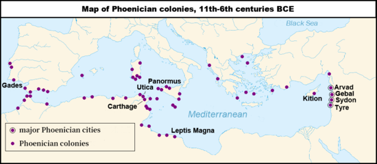
Literary evidence suggests an early Phoenician presence also at Kition which was under Tyrian rule at the beginning of the 10th century BC.[13] Some Phoenician merchants who were believed to come from Tyre colonized the area and expanded the political influence of Kition. After c. 850 BC the sanctuaries [at the Kathari site] were rebuilt and reused by the Phoenicians."[11]
The kingdom was under Egyptian domination from 570 to 545 BC.[14] Persia ruled Cyprus from 545 BC.[14] Kings of the city are referred to by name from 500 BC—in Phoenician texts and as inscriptions on coins.[15]
Marguerite Yon claims that literary texts and inscriptions suggest that by the Classical period Kition was one of the principal local powers, along with its neighbour Salamis.[15] In 499 BC Cypriot kingdoms (including Kition) joined Ionia's revolt against Persia.[16]
Persian rule of Cyprus ended in 332 BC.
Ptolemy I conquered Cyprus in 312 BC and killed Poumyathon, the Phoenician king of Kition, and burned the temples.[14] Shortly afterwards the Cypriot city-kingdoms were dissolved and the Phoenician dynasty of Kition was abolished. Following these events the area lost its religious character.[17]
However, a trading colony from Kition established at Piraeus had prospered to the point that, in 233 BC they requested and received permission for the construction of a temple dedicated to Astarte".[18]
Cyprus was annexed by Rome in 58 BC.[19]
Strong[1] earthquakes hit the city in 76 AD and the year after, but the city seems to have been prosperous during Roman times. A curator civitatis, or financial administrator of the city, was sent to Kition from Rome during the rule of Septimius Severus.[19]
Earthquakes of 322 and 342 AD "caused the destruction not only of Kition but also of Salamis and Pafos".[1]
The Kition archaeological sites
Kition was first systematically[20] excavated by the Swedish Cyprus Archaeological Expedition in 1929 (under the direction of Einar Gjerstad).
Archaeology is continuing near the Kathari site. A magnificent 20m-long Roman mosaic showing the labours of Hercules was discovered in a baths building in 2016.[21] It was found under Kyriakou Matsi Street when clearing a sewer and is expected to be transferred to the museum.[22]
The Kathari site (a.k.a. Area II)
This site is located around 500 metres north of the Bamboula site and sometimes referred to as "Kition Area II".[9] The Department of Antiquities (under the direction of Vassos Karageorghis) started excavating in 1959[23] continuing until 1981.[24]
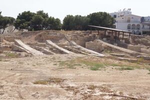
Excavations have revealed part of a defensive wall, dating from the 13th century BC[25] and remains of five temples including cyclopean walls. The largest temple's (horizontal) dimensions were 35 m by 22 m.[26] and was built using ashlar blocks. Temple (2) was rebuilt—around 1200 BC.[14] Temple (1) has Late Bronze Age graffiti of ships on the façade of the south wall.[14]
The Bamboula site
The site is located around 50 metres north of the Larnaca Museum. In 1845 the Sargon Stele was found here, together with a gilded silver plakette now in the Louvre.
A British Expedition first excavated the site in 1913.
A French team from the University of Lyon[20] started excavating in 1976.[27][28] when traces of settlement dating to the tenth century BC were found along ramparts next to the port at Bamboula.[15] The site also consists of a sanctuary of Astarte and a sanctuary of Melkart.[20] The earliest sanctuary was built in the 9th century BC.[29]
1987[30] saw the discovery of the Phoenician harbour for warships built in the 5th century BC. In its final stage, it consisted of ship sheds (six of them have been recorded), 6 metres wide and about 38 to 39 meters long, with shipways on which triremes were pulled up to dry under tiled roofs[29]
Other archaeological sites at Kition
Five built tombs—hypogeum is another name for this type of tombs—have been discovered at Kition—the Vangelis Tomb, Godham's Tomb, the Phaneromeni, and the Turabi Tekke tomb.[31] Two important stele with inscriptions in the Phoenician script were found in the Turabi Tekke cemetery in the late nineteenth century. They are now in the British Museum's collection.[32]
Kition Area I, "close to the west [city] wall of the Pre-Phoenician period, seems to have been a residential area" according to architectural and moveable finds.[19] "Kition Area III" and "-IV" are names of other archaeological sites at Kition.[9]
The "mound gate" in the city wall was located in the vicinity northwest of the Phaneromeni Tomb.[33]
There was also an acropolis.[34]
Necropolis
Sophocles Hadjisavvas has said that "the necropolis of Kition is the most extensively investigated burial ground on the island of Cyprus".[35] "The necropolis [of Kition] extends from the Ayios Prodromos and the area of Agios Ioannis "Pervolia"[36] and "Mnemata" (Northern Necropolis) to Ayios Georghios Kontos and the Chrysosotiros church (Soteros quarter), (Western Necropolis)."[31] A "part of the Kition necropolis became the subject of rescue work at the site of Agios Prodromos".[35]
The Mnemata Site
Other uses of the name
One sports club uses the name Kition - AEK Kition.
See also
References
Citations
- ^ أ ب ت Flourentzos, Paulos (1996). A Guide to the Larnaca District Museum. Nicosia: Ministry of Communications and Works - Department of Antiquities. p. 18. ISBN 978-9963-36-425-1. OCLC 489834719.
- ^ أ ب Radner, Karen (2010). The Stele of Sargon II of Assyria at Kition: A focus for an emerging Cypriot identity?. p. 443. ISBN 978-3-447-06171-1.
- ^ أ ب J. Simons (1937). Handbook for the study of Egyptian topographical lists relating to Western Asia. p. 169.
- ^ Huss (1985), p. 568.
- ^ أ ب Yon, Marguerite; Childs, William A. P. (November 1997). "Kition in the Tenth to Fourth Centuries B. C." Bulletin of the American Schools of Oriental Research. 308 (308): 11. doi:10.2307/1357405. JSTOR 1357405. S2CID 156694103.
- ^
 Chisholm, Hugh, ed. (1911). . دائرة المعارف البريطانية. Vol. 6 (eleventh ed.). Cambridge University Press. p. 397.
 {{cite encyclopedia}}: Cite has empty unknown parameter:|coauthors=(help) - ^ أ ب Flourentzos, Paulos (1996). A Guide to the Larnaca District Museum. Nicosia: Ministry of Communications and Works - Department of Antiquities. p. 6. ISBN 978-9963-36-425-1. OCLC 489834719.
- ^ Josephus, Flavius. The Antiquities of the Jews 1.6.1. Translated by William Whiston. Greek original.
- ^ أ ب ت According to the text on the plaque closest to the excavation pit at the Kathari site (as of 2013).
- ^ Orphanides, Andreas G.. "The Mycenaeans in Cyprus: Economic, Political and Ethnic Implications" in Lines Between: Culture and Empire in the Eastern Mediterranean Conference, 3–6 June 2015, Nicosia, Cyprus..
- ^ أ ب Excerpt of text on the only plaque at the Kathari site (as of 2013).
- ^ Excerpt of wall mounted text in exhibit room number two at Larnaca District Museum.
- ^ Hadjisavvas, Sophocles (2013). The Phoenician Period Necropolis of Kition, Volume I. Shelby White and Leon Levy Program for Archaeological Publications. p. 1. Archived from the original on 2016-03-04.
- ^ أ ب ت ث ج According to text on one of the signs at the entrance of the Kathari site.
- ^ أ ب ت Yon, Marguerite; William A. P. (Nov 1997). "Kition in the Tenth to Fourth Centuries B. C.". Bulletin of the American Schools of Oriental Research. 308 (308): 9–17. doi:10.2307/1357405. JSTOR 1357405. S2CID 156694103.
- ^ According to text mounted in the coin display at Larnaca District Museum
- ^ Text on the plaque (on the grounds of Larnaca District Archaeological Museum) facing the Bamboula site.
- ^ Flourentzos, Paulos (1996). A Guide to the Larnaca District Museum. Nicosia: Ministry of Communications and Works - Department of Antiquities. p. 15. ISBN 978-9963-36-425-1. OCLC 489834719.
- ^ أ ب ت Flourentzos, Paulos (1996). A Guide to the Larnaca District Museum. Nicosia: Ministry of Communications and Works - Department of Antiquities. p. 5. ISBN 978-9963-36-425-1. OCLC 489834719.
- ^ أ ب ت "Kition" (in اليونانية). Mcw.gov.cy. Retrieved 2014-04-25.
- ^ http://theartnewspaper.com/news/archeology/ancient-roman-mosaics-uncovered-in-cyprus-/
- ^ http://www.ekathimerini.com/210444/article/ekathimerini/life/unique-roman-era-mosaic-of-herculess-labors-to-go-to-larnaca-museum
- ^ "Department of Antiquities - Kition" (in اليونانية). Mcw.gov.cy. Retrieved 2014-04-25.
- ^ According to the text on the plaque closest to the excavation pit of the Kathari site (as of 2013).
- ^ Excerpt of text on the only plaque at the Kathari site (as of 2013).
- ^ Excerpt of wall mounted text in exhibit room number 2 at Larnaca District Museum.
- ^ Yon, Marguerite; William A. P. (Nov 1997). "Kition in the Tenth to Fourth Centuries B. C.". Bulletin of the American Schools of Oriental Research. 308 (308): 9–17. doi:10.2307/1357405. JSTOR 1357405. S2CID 156694103.
- ^ Recent Holocene paleo-environmental evolution and coastline changes of Kition, Larnaca, Cyprus, Mediterranean Sea[dead link]
- ^ أ ب According to text on the plaque (in the grounds of Larnaca Museum) facing the Bamboula site.
- ^ Jean-Christophe Sourisseau (1970-01-01). "Le port de guerre de Kition". Academia.edu. Retrieved 2014-04-25.
- ^ أ ب Excerpt of wall mounted text at Larnaca District Museum.
- ^ British Museum Collection
- ^ According to text on a map that is part of one of the signs at the entrance of the Kition-Kathari site.
- ^ According to display number 2 in exhibit room number 2 at the Larnaca District Museum
- ^ أ ب "The Phoenician Period Necropolis of Kition, Volume I". Fas.harvard.edu. Archived from the original on 2016-03-04. Retrieved 2014-04-25.
- ^ S. Fourrier, A. Cannavo, A. Rabot, Kition-Bamboula VII. Fouilles dans les nécropoles de Kition (2012-2014)
Bibliography
- Huss, Werner (1985), Geschichte der Karthager, Munich: C.H. Beck, ISBN 9783406306549, https://books.google.com/books?id=NvEK7kc3qnQC. (in ألمانية)
External links
- The port of the Kingdom of Kition
- Photos: Ancient Ruins of Kition Kathari
- StoryMap (S. Fourrier, A. Rabot): https://arcg.is/1WWfPi
- مقالات المعرفة المحتوية على معلومات من دائرة المعارف البريطانية طبعة 1911
- CS1 اليونانية-language sources (el)
- Articles with dead external links from June 2016
- Pages using gadget WikiMiniAtlas
- Short description is different from Wikidata
- Articles containing Ancient Greek (to 1453)-language text
- Articles containing Phoenician-language text
- Pages using Lang-xx templates
- Articles containing لاتينية-language text
- Articles with hatnote templates targeting a nonexistent page
- Articles with ألمانية-language sources (de)
- Coordinates on Wikidata
- Archaeological sites in Cyprus
- Mycenaean Greece
- Bronze Age Cyprus
- مدن-دويلات
- Former populated places in Cyprus
- Phoenician colonies in Cyprus
- Cities in ancient Cyprus


