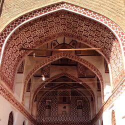
قائن
قائن
فارسية: قاین Qaen | |
|---|---|
مدينة | |
 | |
| الإحداثيات: 33°44′00″N 59°10′52″E / 33.73333°N 59.18111°E[1] | |
| البلد | إيران |
| المحافظة | جنوب خراسان |
| المقاطعة | قائن |
| البخش | المركزي |
| التعداد (2016)[2] | |
| • الإجمالي | 42٬323 |
| منطقة التوقيت | UTC+3:30 (IRST) |
قائن أو قاين (فارسية: قائن ؛ Qaen)[أ] is a city in the Central District of Qaen County, South Khorasan province, Iran, and serves as capital of both the county and the district.[4]
At the 2006 census, its population was 32,474 in 8,492 households.[5][6] The following census in 2011 counted 40,226 people in 10,473 households.[7] The latest census in 2016 showed a population of 42,323 people in 11,920 households.[2]
التاريخ
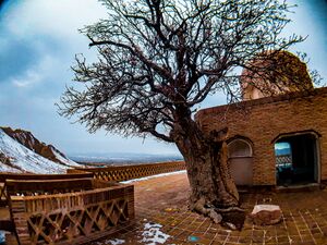
 قبر بزرمهر قائني يضم شجرة بانه عمرها 700 عام. |
According to the latest archeological findings, the history of settlement in the city of Qain dates back to the Middle Paleolithic era (about 30 thousand years ago). As a result of the archaeological excavations of the American delegation in Khonik Cave in the south of this city, a number of stone tools related to the Middle Paleolithic period were found in this cave, which is very important in terms of archaeological and anthropological studies. Also, the existence of a large number of ancient hills around the city of Qain, which, based on preliminary observations from prehistoric times, have traces and signs that prove the long history of settlement in this region of Iran.
يقال أن مدينة قائن بناها لهراسب، والد گشتاسب.
The Middle Persian work Shahrestaniha i Eranshahr mentions this city, and attributes its foundation to Sined Ninoh Kitop in 1588.[8]
أبرز السكان
انظر أيضاً
ملاحظات
- ^ Also تـُرَوْمَن Ghayen أو Qayen أو Ghaen؛ من الفارسية المتوسطة: kʾyyn, Kāyēn[3]
المراجع
- ^ OpenStreetMap contributors (21 March 2023). "Qaen, Qaen County" (Map). OpenStreetMap. Retrieved 21 March 2023.
- ^ أ ب "Census of the Islamic Republic of Iran, 1395 (2016)". AMAR (in الفارسية). The Statistical Center of Iran. p. 29. Archived from the original (Excel) on 17 October 2020. Retrieved 19 December 2022.
- ^ قائن can be found at GEOnet Names Server, at this link, by opening the Advanced Search box, entering "-3078747" in the "Unique Feature Id" form, and clicking on "Search Database".
- ^ Habibi, Hassan (21 June 1369). "Approval of the organization and chain of citizenship of the elements and units of the divisions of Khorasan province, centered in Mashhad". Lamtakam (in الفارسية). Ministry of Interior, Defense Political Commission of the Government Council. Archived from the original on 27 December 2023. Retrieved 27 December 2023.
- ^ "Census of the Islamic Republic of Iran, 1385 (2006)". AMAR (in الفارسية). The Statistical Center of Iran. p. 29. Archived from the original (Excel) on 20 September 2011. Retrieved 25 September 2022.
- ^ "Where is Qaen City? Everything You Must Know 2021". 16 September 2021. Archived from the original on 16 September 2021. Retrieved 16 September 2021.
- ^ "Census of the Islamic Republic of Iran, 1390 (2011)". Syracuse University (in الفارسية). The Statistical Center of Iran. p. 29. Archived from the original (Excel) on 20 January 2023. Retrieved 19 December 2022.
- ^ Daryaee, Touraj (2002), Ziai, Hossein, ed., Šahrestānīhā Ī Ērānšahr, Intellectual Traditions Series, No. 7, ISBN 1-56859-143-8, https://archive.org/details/SahrestanihaIEransahr/page/n49/mode/2up?view=theater, retrieved on 12 Feb 2023
خطأ لوا في وحدة:Authority_control على السطر 278: attempt to call field '_showMessage' (a nil value).
- Pages using gadget WikiMiniAtlas
- Articles containing Middle Persian-language text
- CS1 الفارسية-language sources (fa)
- Short description is different from Wikidata
- Articles with hatnote templates targeting a nonexistent page
- Articles containing فارسية-language text
- Coordinates on Wikidata
- مدن محافظة جنوب خراسان
- أماكن مأهولة في مقاطعة قائن
- أماكن مأهولة تأسست في القرن 15

