طبس
Tabas
فارسية: طبس | |
|---|---|
City | |
 Hosein Ibn Mosa Alkazem's Shrine in Tabas | |
 Tabas | |
| الإحداثيات: 33°35′46″N 56°55′41″E / 33.59611°N 56.92806°E[1] | |
| Country | Iran |
| Province | South Khorasan |
| County | Tabas |
| District | Central |
| أعلى منسوب | 730 m (2٬400 ft) |
| أوطى منسوب | 660 m (2٬170 ft) |
| التعداد (2016)[2] | |
| • الإجمالي | 39٬676 |
| منطقة التوقيت | UTC+3:30 (IRST) |
طَبَس مدينة إيرانية تقع في شمال شرق إيران، طبس هي مركز بلدية طبس في محافظة خراسان الجنوبية، يبلغ عدد سكان المدينة حوالي 30 ألف نسمة (2006).[3]
التاريخ
Early history
The history of Tabas dates back to pre-Islamic times. It was an important outpost of the Sassanid empire.
Due to its strategic location at the edge of the Great Salt Desert, and at the confluence of many roads, the geographer al-Baladhuri called the city "the Gate of Khurasan".[4] In the early Islamic period it was known as Tabas al-Tamr (حرفياً 'Tabas of the Dates') due to a large forest of date palms that grew there, and later as Tabas Gilaki after a famous governor of the city, Abu'l-Hasan ibn Muhammad Gilaki, who in the mid-11th century had pacified the region.[4] Along with the town of Tabas-e Masina further east, it gave its name to the local district, Tabasayn.[4] In the 10th–11th centuries, the town is described as well fortified, with several villages around. Medieval and geographers note that it was amply supplied with water due to underground wells; the town even featured hot baths, and extensive lemon and orange plantations.[4] In the late 11th century, it became part of the Nizari Ismaili state, and was besieged by the Seljuk Turks under Ahmad Sanjar in 1102.[4]
Tabas was spared when the Mongols attacked Iran. It had a local government incorporating not only Tabas but also Ferdows and Gonabad. After the death of Nader Shah in 1747, it as under the control of the Zangu'i Arabs as an independent state which included nearby Tun.[5][6] For a time they even kidnapped Nader Mirza Afshar and placed the Kurds of Khabushan in control of Mashhad.
Earthquake of 1978
تعرضت المدينة لزلزال مدمر عام 1978 بلغت قوة الزلزال 7.8 على مقياس رختر تسبب في تدمير المدينة بشكل كلي ومقتل 15,000 فرد من سكانها. أعيد بناء المدينة من جديد من ذلك الحين.
Operation Eagle Claw
The failed rescue American operation Operation Eagle Claw on 24–25 April 1980 to free American hostages in Tehran occurred near Tabas in Tabas Country about 127km southwest of Tabas town by the road to Yazd location (33.07020674739667;55.89196171977231).[7] In Iran, the operation is called amaliat tabas (Tabas operation), and the significance and aftermath of the failed operation made the city Tabas known in almost every corner of Iran.[8] The Tabas air defense system is accordingly named so.
Administrative changes
At first, Tabas County was part of Khorasan province. It became a part of Yazd province in 2001,[9] transferring to South Khorasan province in 2013.[10]
Demographics
Language
The people of Tabas speak a Khorasani accent of Persian that sounds somewhat different from the standard Iranian version ("Tehrani accent").[بحاجة لمصدر]
Population
At the time of the 2006 National Census, the city's population was 30,681 in 7,962 households, when it was in Yazd province.[11] The following census in 2011 counted 35,150 people in 9,903 households.[12] The 2016 census measured the population of the city as 39,676 people in 11,876 households,[2] by which time the county had been separated from the province and become a part of South Khorasan province.[10]
Geography
Location
Tabas is in central Iran, 950 kilometers southeast of Tehran, in South Khorasan Province.[بحاجة لمصدر]
It is a desert city with many date and citrus trees. It has a 300-year-old public garden (Bagh-e-Golshan).[13] There is also a shrine in Tabas that is visited every year by thousands of pilgrims. Tabas has two universities with 2,500 to 3,500 students.[14] The city has hot summers, and people rarely see a winter snowfall.
Climate
Tabas has a hot desert climate (Köppen BWh).
| Climate data for Tabas | |||||||||||||
|---|---|---|---|---|---|---|---|---|---|---|---|---|---|
| Month | Jan | Feb | Mar | Apr | May | Jun | Jul | Aug | Sep | Oct | Nov | Dec | Year |
| Mean daily maximum °C (°F) | 13.6 (56.5) |
17.2 (63.0) |
23.0 (73.4) |
29.4 (84.9) |
35.3 (95.5) |
40.7 (105.3) |
42.2 (108.0) |
40.5 (104.9) |
37.1 (98.8) |
30.6 (87.1) |
22.6 (72.7) |
15.6 (60.1) |
29.0 (84.2) |
| Daily mean °C (°F) | 7.7 (45.9) |
10.9 (51.6) |
16.3 (61.3) |
22.4 (72.3) |
28.1 (82.6) |
33.0 (91.4) |
35.0 (95.0) |
33.0 (91.4) |
28.8 (83.8) |
22.6 (72.7) |
15.4 (59.7) |
9.4 (48.9) |
21.9 (71.4) |
| Mean daily minimum °C (°F) | 1.8 (35.2) |
4.6 (40.3) |
9.5 (49.1) |
15.4 (59.7) |
20.9 (69.6) |
25.3 (77.5) |
27.7 (81.9) |
25.4 (77.7) |
20.5 (68.9) |
14.6 (58.3) |
8.2 (46.8) |
3.3 (37.9) |
14.8 (58.6) |
| Average precipitation mm (inches) | 16.0 (0.63) |
14.2 (0.56) |
16.8 (0.66) |
12.6 (0.50) |
4.1 (0.16) |
0.2 (0.01) |
0.1 (0.00) |
0.0 (0.0) |
0.0 (0.0) |
1.4 (0.06) |
3.9 (0.15) |
12.9 (0.51) |
82.2 (3.24) |
| Average precipitation days (≥ 1.0 mm) | 3 | 2 | 2 | 1 | 0 | 0 | 0 | 0 | 0 | 0 | 1 | 2 | 11 |
| Average relative humidity (%) | 57 | 48 | 39 | 33 | 26 | 19 | 19 | 19 | 21 | 28 | 39 | 52 | 33 |
| Source: https://irimo.ir | |||||||||||||
Economy
Agricultural products
The agricultural products of this desert city are very significant. Products such as: oranges, pistachios, dates, persimmons, summer fruits and daffodils; Also, tea bread, chickpea bread, and jams that are prepared from agricultural products, such as: spring orange jam, balang jam, orange peel jam, and Tabas mountain and local liqueurs.[15]
Mines
Tabas has some of the richest coal mines of Iran.[16]
Transportation
Multiple bus lines, a railroad station and an airport connect Tabas to Mashhad, Yazd, Tehran, Kerman and Birjand (the capital city of South Khorasan province).
أعلام
- عباس واعظ طبسي, born 25 June 1935 in Tabas; Grand Imam and Chairman of the Astan Quds Razavi board
- مسعود رجوي, born 18 August 1948 in Tabas; one of the two leaders of the People's Mujahedin of Iran
معرض صور

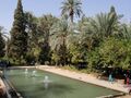
Golshan Garden


See also
Notes
مراجع
- ^ OpenStreetMap contributors (23 مارس 2023). "Tabas, Tabas County" (Map). OpenStreetMap (in الفارسية). Retrieved 23 مارس 2023.
- ^ أ ب "Census of the Islamic Republic of Iran, 1395 (2016)". AMAR (in الفارسية). The Statistical Center of Iran. p. 29. Archived from the original (Excel) on 17 أكتوبر 2020. Retrieved 19 ديسمبر 2022.
- ^ Habibi, Hassan (21 يونيو 1369). "Approval of the organization and chain of citizenship of the elements and units of the divisions of Khorasan province, centered in Mashhad". Lamtakam (in الفارسية). Ministry of Interior, Defense Political Commission of the Government Council. Archived from the original on 27 ديسمبر 2023. Retrieved 27 ديسمبر 2023.
- ^ أ ب ت ث ج قالب:Lands of the Eastern Caliphate
- ^ Malcolm, Sir John (1829). The History of Persia: From the Most Early Period to the Present Time (in الإنجليزية). Murray.
- ^ Noelle-Karimi, Christine (2014). The Pearl in Its Midst: Herat and the Mapping of Khurasan (15th-19th Centuries) (in الإنجليزية). Austrian Academy of Sciences Press. ISBN 978-3-7001-7202-4.
- ^ Operation Eagle Claw, 2455 Teller Road, Thousand Oaks California 91320 United States: SAGE Publications, Inc., 2003, doi:, ISBN 9780761924081, http://dx.doi.org/10.4135/9781412952590.n324, retrieved on 2023-06-27
- ^ fa:عملیات طبس
- ^ Adel, Gholam Ali Haddad. "The law of division of Khorasan province into three provinces". Qavanin (in الفارسية). Islamic Council. Archived from the original on 30 أكتوبر 2020. Retrieved 27 ديسمبر 2023.
- ^ أ ب Rahimi, Mohammad Reza (19 ديسمبر 2013). "Approval letter regarding the abstraction of Tabas County from Yazd province and its annexation to South Khorasan province". Research Center of the System of Laws of the Islamic Council of the Farabi Library (in الفارسية). Ministry of Interior, Council of Ministers. Archived from the original on 29 مايو 2013. Retrieved 25 نوفمبر 2023.
- ^ "Census of the Islamic Republic of Iran, 1385 (2006)". AMAR (in الفارسية). The Statistical Center of Iran. p. 21. Archived from the original (Excel) on 20 سبتمبر 2011. Retrieved 25 سبتمبر 2022.
- ^ "Census of the Islamic Republic of Iran, 1390 (2011)". Syracuse University (in الفارسية). The Statistical Center of Iran. p. 21. Archived from the original (Excel) on 20 يناير 2023. Retrieved 19 ديسمبر 2022.
- ^ Samira (18 يناير 2019). "Bagh-e-Golshan". Iran Asia. Retrieved 22 أبريل 2021.
- ^ "Islamic Azad University Tabas - | Admission | Tuition | University". www.unipage.net. Retrieved 11 يوليو 2022.
- ^ Group, Baniboom. "Tabas - Tabas City Ecotourist and Tourist and Sights list". Baniboom (in الإنجليزية). Retrieved 3 مايو 2022.
- ^ "Visit Tabas Tourist Attractions, Historical & Natural | Destination Iran". www.destinationiran.com (in الإنجليزية الأمريكية). 5 أبريل 2020. Retrieved 11 أغسطس 2022.
| العاصمة |  | ||||||||||||||||||
|---|---|---|---|---|---|---|---|---|---|---|---|---|---|---|---|---|---|---|---|
| المقاطعات والمدن | |||||||||||||||||||
| المعالم |
| ||||||||||||||||||
- Pages using gadget WikiMiniAtlas
- CS1 الفارسية-language sources (fa)
- CS1 الإنجليزية الأمريكية-language sources (en-us)
- Short description is different from Wikidata
- Articles with hatnote templates targeting a nonexistent page
- Use dmy dates from March 2023
- Articles containing فارسية-language text
- Coordinates on Wikidata
- مقالات ذات عبارات بحاجة لمصادر
- Portal-inline template with redlinked portals
- Pages with empty portal template
- Cities in South Khorasan province
- Populated places in Tabas County
- Populated places destroyed by earthquakes
- محافظة يزد
- مدن محافظة خراسان الجنوبية
- مقاطعة طبس
- واحات إيران