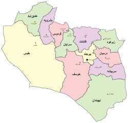
مقاطعة قائن
Qaen County
فارسية: شهرستان قائن | |
|---|---|
 Location of Qaen County in South Khorasan province (top right, purple) | |
 Location of South Khorasan province in Iran | |
| الإحداثيات: 33°39′N 59°15′E / 33.650°N 59.250°E[1] | |
| البلد | إيران |
| المحافظة | جنوب خراسان |
| العاصمة | قائن |
| البخوش | Central، Nimbeluk، Sedeh |
| التعداد (2016)[2] | |
| • الإجمالي | 116٬181 |
| منطقة التوقيت | UTC+3:30 (IRST) |
| مقاطعة قائن at GEOnet Names Server | |
مقاطعة قائن (فارسية: شهرستان قائن؛ Qaen County)[أ] توجد في محافظة جنوب خراسان، إيران. Its capital is the city of Qaen.[3] This city is known as “Capital of Saffron”.
التاريخ
After the 2011 National Census, Zirkuh and Zohan Districts were separated from the county in the establishment of Zirkuh County.[4]
السكان
التعداد
At the time of the 2006 census, the county's population was 137,357 in 35,783 households.[5] The following census in 2011 counted 152,401 people in 42,002 households.[6] The 2016 census measured the population of the county as 116,181 in 34,794 households.[2]
التقسيمات الإدارية
Qaen County's population history and administrative structure over three consecutive censuses are shown in the following table.
| Administrative Divisions | 2006[5] | 2011[6] | 2016[2] |
|---|---|---|---|
| Central District | 62,040 | 70,686 | 73,917 |
| Mahyar RD | 4,874 | 4,610 | 4,445 |
| Pishkuh RD | 3,295 | 3,837 | 3,793 |
| Qaen RD | 18,252 | 18,483 | 19,758 |
| Esfeden (city) | 3,145 | 3,530 | 3,598 |
| Qaen (city) | 32,474 | 40,226 | 42,323 |
| Nimbeluk District | 18,396 | 20,152 | 19,791 |
| Karghond RD | 4,508 | 5,442 | 4,786 |
| Nimbeluk RD | 5,072 | 4,556 | 4,563 |
| Khezri Dasht Beyaz (city) | 4,930 | 5,761 | 5,680 |
| Nimbeluk (city) | 3,886 | 4,393 | 4,762 |
| Sedeh District | 18,792 | 20,482 | 22,473 |
| Afriz RD | 5,765 | 6,276 | 7,123 |
| Paskuh RD | 6,407 | 7,357 | 8,441 |
| Sedeh RD | 3,569 | 3,264 | 3,180 |
| Arianshahr (city) | 3,051 | 3,585 | 3,729 |
| Zirkuh District[ب] | 26,203 | 29,844 | |
| Petergan RD | 5,865 | 6,375 | |
| Shaskuh RD | 8,329 | 9,752 | |
| Zirkuh RD | 7,676 | 7,799 | |
| Hajjiabad (city) | 4,333 | 5,918 | |
| Zohan District[ب] | 11,926 | 11,237 | |
| Afin RD | 5,311 | 4,760 | |
| Zohan RD | 5,908 | 5,058 | |
| Zohan (city) | 707 | 1,419 | |
| Total | 137,357 | 152,401 | 116,181 |
| RD = Rural District | |||
انظر أيضاً
 وسائط متعلقة بـمقاطعة قائن من مشاع المعرفة.
ملاحظات
- ^ وتُعرف أيضاً بإسم مقاطعة قاين
- ^ أ ب Transferred to Zirkuh County[4]
المراجع
- ^ OpenStreetMap contributors (21 مارس 2023). "Qaen County" (Map). OpenStreetMap (in الفارسية). Retrieved 21 مارس 2023.
- ^ أ ب ت "Census of the Islamic Republic of Iran, 1395 (2016)". AMAR (in الفارسية). The Statistical Center of Iran. p. 29. Archived from the original (Excel) on 17 أكتوبر 2020. Retrieved 19 ديسمبر 2022.
- ^ Habibi, Hassan (21 يونيو 1369). "Approval of the organization and chain of citizenship of the elements and units of the divisions of Khorasan province, centered in Mashhad". Lamtakam (in الفارسية). Ministry of Interior, Defense Political Commission of the Government Council. Archived from the original on 27 ديسمبر 2023. Retrieved 27 ديسمبر 2023.
- ^ أ ب Rahimi, Mohammad Reza (5 أغسطس 2013). "Reforms and creation of country divisions in Qaen and Zirkuh Counties in South Khorasan province". Qavanin (in الفارسية). Ministry of Interior, Board of Ministers. Archived from the original on 2 فبراير 2021. Retrieved 24 نوفمبر 2023.
- ^ أ ب "Census of the Islamic Republic of Iran, 1385 (2006)". AMAR (in الفارسية). The Statistical Center of Iran. p. 29. Archived from the original (Excel) on 20 سبتمبر 2011. Retrieved 25 سبتمبر 2022.
- ^ أ ب "Census of the Islamic Republic of Iran, 1390 (2011)". Syracuse University (in الفارسية). The Statistical Center of Iran. p. 29. Archived from the original (Excel) on 20 يناير 2023. Retrieved 19 ديسمبر 2022.
