غرب مدلاندز (مقاطعة)
West Midlands | |||||||||||||||||||||||||||||||||||||||||||
|---|---|---|---|---|---|---|---|---|---|---|---|---|---|---|---|---|---|---|---|---|---|---|---|---|---|---|---|---|---|---|---|---|---|---|---|---|---|---|---|---|---|---|---|
 | |||||||||||||||||||||||||||||||||||||||||||
 | |||||||||||||||||||||||||||||||||||||||||||
| البلد | المملكة المتحدة | ||||||||||||||||||||||||||||||||||||||||||
| المقاطعة | إنگلترة | ||||||||||||||||||||||||||||||||||||||||||
| المنطقة | West Midlands | ||||||||||||||||||||||||||||||||||||||||||
| التأسيس | 1 April 1974 | ||||||||||||||||||||||||||||||||||||||||||
| أسسها | Local Government Act 1972 | ||||||||||||||||||||||||||||||||||||||||||
| منطقة التوقيت | UTC±00:00 (توقيت گرينتش المتوسط) | ||||||||||||||||||||||||||||||||||||||||||
| • الصيف (التوقيت الصيفي) | UTC+01:00 (توقيت بريطانيا الصيفي) | ||||||||||||||||||||||||||||||||||||||||||
| أعضاء البرلمان |
| ||||||||||||||||||||||||||||||||||||||||||
| الشرطة | West Midlands Police | ||||||||||||||||||||||||||||||||||||||||||
| |||||||||||||||||||||||||||||||||||||||||||
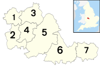
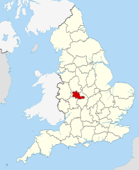
غرب مدلاندز West Midlands هي مقاطعة عمرانية ومنطقة سلطة مجمعة في غرب-وسط إنگلترة بتعداد مقدر في 2019 بـ 2,928,592 نسمة.[3][4] مما يجعلها ثاني أكبر المقاطعات تعداداً في إنگلترة بعد لندن الكبرى. وقد أنشئت في 1974 بمقتضى قانون الحكم المحلي 1972 لتشمل مناطق في Staffordshire, Worcestershire and Warwickshire. The county is a NUTS 2 region within a wider NUTS 1 region of the same name. It covers seven metropolitan boroughs: Birmingham, Coventry, Wolverhampton, Dudley, Sandwell, Solihull and Walsall.
. . . . . . . . . . . . . . . . . . . . . . . . . . . . . . . . . . . . . . . . . . . . . . . . . . . . . . . . . . . . . . . . . . . . . . . . . . . . . . . . . . . . . . . . . . . . . . . . . . . . . . . . . . . . . . . . . . . . . . . . . . . . . . . . . . . . . . . . . . . . . . . . . . . . . . . . . . . . . . . . . . . . . . . .
التاريخ
خلق المقاطعة
في 1974، دخل قانون الحكم المحلي 1972 حيز التنفيذ، فخلق المقاطعة العمرانية "غرب مدلاندز".
| post-1974 | pre-1974 | ||||
|---|---|---|---|---|---|
| Metropolitan county | Metropolitan borough | County boroughs | Non-county boroughs | Urban districts | Rural districts |
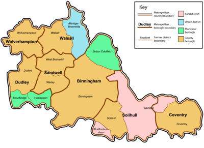 |
Birmingham | Birmingham | Sutton Coldfield | – | – |
| كوڤنتري | Coventry | – | – | Meriden (part)[5] | |
| Dudley | Dudley | – | – | ||
| Sandwell | – | – | – | ||
| Solihull | Solihull | – | – |
| |
| Walsall | Walsall | – | Aldridge-Brownhills | ||
| وولڤرهامپتون | وولڤرهامپتون | – | – | – | |
مجلس مقاطعة غرب مدلاندز

الجغرافيا
الديمغرافيا
المعالم
| المفتاح | |
| كنيسة/كاتدرائية | |
| منطقة مفتوحة للمعاقين | |
| منتزه ترفيهي/حديقة ملاهي | |
| قلعة | |
| منتزه المقاطعة | |
| تراث إنگليزي | |
| هيئة الغابات | |
| سكك حديدية تراثية | |
| بيت تاريخي | |
| متحف (مجاني/غير مجاني) | |
| صندوق وطني | |
| مسرح | |
| حديقة حيوان | |
- Ackers Adventure, Birmingham,

- Aston Hall, Birmingham

- Bantock House Museum and Park, Wolverhampton

- Bescot Stadium (Walsall F.C.)
- Bilston Craft Gallery, Wolverhampton

- Birmingham Botanical Gardens

- Birmingham Bullring
- Birmingham Museum & Art Gallery

- Birmingham Hippodrome

- Black Country Living Museum, Dudley

- Blakesley Hall, Birmingham

- كادبري ورلد, Bournville, Birmingham

- Castle Bromwich Hall, Solihull

- Coventry Cathedral

- Coventry SkyDome Arena
- Coventry Transport Museum

- قلعة ددلي

- حديقة حيوان ددلي

- Edgbaston Cricket Ground, Birmingham
- International Convention Centre (including Symphony Hall), Birmingham

- Merry Hill Shopping Centre, Dudley
- Molineux Stadium (Wolverhampton Wanderers F.C.)
- Moseley Old Hall, Wolverhampton


- National Exhibition Centre
- National Indoor Arena (NIA), Birmingham
- Sea Life Centre, Birmingham

- Netherton Tunnel, Dudley
- The New Art Gallery Walsall, Walsall

- Perrott's Folly, Birmingham
- Red House Glass Cone, Stourbridge

- Ricoh Arena (Coventry City Football Club)
- Sandwell Valley Country Park, West Bromwich

- Sarehole Mill, Birmingham

- St Andrew's (Birmingham City Football Club)
- St Peter's Collegiate Church, Wolverhampton

- Star City
- The Hawthorns (West Bromwich Albion Football Club)
- Thinktank Millennium Point, Birmingham

- Tyseley Locomotive Works, Birmingham

- University of Birmingham
- Villa Park (Aston Villa Football Club)
- Walsall Art Gallery

- West Park, Wolverhampton

- Wightwick Manor, Wolverhampton


- Winterbourne Botanic Garden, Birmingham

- Wolverhampton Art Gallery, Wolverhampton

- Wolverhampton Civic Hall, Wolverhampton
- Wolverhampton Grand Theatre, Wolverhampton

- Wolverhampton Racecourse, Wolverhampton
. . . . . . . . . . . . . . . . . . . . . . . . . . . . . . . . . . . . . . . . . . . . . . . . . . . . . . . . . . . . . . . . . . . . . . . . . . . . . . . . . . . . . . . . . . . . . . . . . . . . . . . . . . . . . . . . . . . . . . . . . . . . . . . . . . . . . . . . . . . . . . . . . . . . . . . . . . . . . . . . . . . . . . . .
التعليم
The West Midlands contains ten universities, seven of which are located in Birmingham:
- Aston University
- University of Birmingham
- Birmingham City University
- University College Birmingham
- BPP University
- University of Law
- Newman University
الرياضة
| Club | League | City/town | Stadium | Capacity |
|---|---|---|---|---|
| Aston Villa | Premier League | Birmingham | Villa Park | 42,788 |
| Wolverhampton Wanderers | Premier League | Wolverhampton | Molineux | 31,700 |
| Birmingham City | Championship | Birmingham | St Andrew's | 30,079 |
| West Bromwich Albion | Premier League | West Bromwich | The Hawthorns | 26,500 |
| Coventry City | Championship | Coventry | Ricoh Arena | 32,609 |
| Walsall | League Two | Walsall | Bescot Stadium | 11,300 |
انظر أيضاً
- List of ceremonial counties in England by gross value added
- List of conservation areas in the West Midlands
- Evolution of Worcestershire county boundaries
الهامش
- ^ "No. 62943". The London Gazette. 13 March 2020. p. 5161.
- ^ "2011 Census: Key Statistics for Local Authorities in England and Wales". ONS. Archived from the original on 24 فبراير 2016. Retrieved 26 ديسمبر 2012.
- ^ City Population. Retrieved 12 December 2020.
- ^ "Population estimates for the UK, England and Wales, Scotland and Northern Ireland - Office for National Statistics". www.ons.gov.uk. Retrieved 2020-02-19.
- ^ أ ب ت Whitaker's Almanack 1974, complete edition (106th ed.). London: J. Whitaker & Sons. 1973 [1868]. p. 672. ISBN 0-85021-067-4.
وصلات خارجية
- Photographs of Birmingham and the West Midlands
- Identity in the West Midlands
- West Midlands Joint Committee
- Images of West Midlands at the English Heritage Archive
- Pages using gadget WikiMiniAtlas
- Short description is different from Wikidata
- Articles with hatnote templates targeting a nonexistent page
- Pages using infobox settlement with no coordinates
- Pages with empty portal template
- Articles with Curlie links
- Coordinates on Wikidata
- غرب مدلاندز (مقاطعة)
- Metropolitan counties
- غرب ميدلاندز (اقليم)
- أقاليم التصنيف الثاني في المملكة المتحدة
- Counties of England established in 1974
