گالڤستون، تكساس
Galveston, Texas | |
|---|---|
City | |
| City of Galveston | |
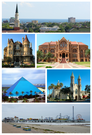
 From upper left: Galveston downtown skyline, Bishop's Palace, Ashbel Smith Building, Moody Gardens Aquarium, St. Mary Cathedral Basilica and Galveston Island Historic Pleasure Pier | |
| الكنية: The Oleander City[1] | |
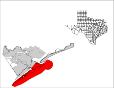
 Location in Galveston County in the state of Texas | |
| الإحداثيات: 29°16′52″N 94°49′33″W / 29.28111°N 94.82583°W | |
| Country | |
| State | |
| County | Galveston |
| Incorporated | 1839 |
| الحكومة | |
| • النوع | Council–manager |
| • Mayor | James D. Yarbrough |
| • City Manager | Brian Maxwell |
| المساحة | |
| • الإجمالي | 208٫3 ميل² (539٫6 كم²) |
| • البر | 46٫1 ميل² (119٫5 كم²) |
| • الماء | 162٫2 ميل² (420٫1 كم²) |
| المنسوب | 7 ft (2 m) |
| التعداد (2010) | |
| • الإجمالي | 47٬743 |
| • الكثافة | 1٬240/sq mi (478٫9/km2) |
| • Demonym | Galvestonian |
| منطقة التوقيت | UTC-6 (CST) |
| • الصيف (التوقيت الصيفي) | UTC-5 (CDT) |
| ZIP codes | 77550-77555 |
| مفتاح الهاتف | 409 |
| FIPS code | 48-28068[2] |
| GNIS feature ID | 1377745[3] |
| الموقع الإلكتروني | cityofgalveston.org |
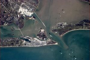
گالڤستون Galveston /ˈɡælvɪstən/ هي مدينة ساحلية تقع في جزيرة گالڤستون وجزيرة پليكان في ولاية تكساس. The community of 208.3 square miles (539 km2), with its population of 47,762 people (2012 Census estimate), is the county seat and second-largest municipality of Galveston County. It is located within Houston–The Woodlands–Sugar Land metropolitan area.
Named after Bernardo de Gálvez y Madrid, Count of Gálvez (born in Málaga, Spain), Galveston's first European settlements on the island were constructed around 1816 by French pirate Louis-Michel Aury to help the fledgling Republic of Mexico fight Spain. The Port of Galveston was established in 1825 by the Congress of Mexico following its successful independence from Spain. The city served as the main port for the Texas Navy during the Texas Revolution, and later served as the capital of the Republic of Texas.
During the 19th century, Galveston became a major U.S. commercial center and one of the largest ports in the الولايات المتحدة. It was devastated by the 1900 Galveston Hurricane, whose effects included flooding and a storm surge. The natural disaster on the exposed barrier island is still ranked as the deadliest in United States history, with an estimated toll of 6,000-8,000 people.
Much of Galveston's modern economy is centered in the tourism, health care, shipping, and financial industries. The 84-acre (340,000 m2) University of Texas Medical Branch campus with an enrollment of more than 2,500 students is a major economic force of the city. Galveston is home to six historic districts containing one of the largest and historically significant collections of 19th-century buildings with over 60 structures listed in the National Register of Historic Places.
. . . . . . . . . . . . . . . . . . . . . . . . . . . . . . . . . . . . . . . . . . . . . . . . . . . . . . . . . . . . . . . . . . . . . . . . . . . . . . . . . . . . . . . . . . . . . . . . . . . . . . . . . . . . . . . . . . . . . . . . . . . . . . . . . . . . . . . . . . . . . . . . . . . . . . . . . . . . . . . . . . . . . . . .
Hurricane of 1900 and recovery

Geography

Climate
| Galveston | ||||||||||||||||||||||||||||||||||||||||||||||||||||||||||||
|---|---|---|---|---|---|---|---|---|---|---|---|---|---|---|---|---|---|---|---|---|---|---|---|---|---|---|---|---|---|---|---|---|---|---|---|---|---|---|---|---|---|---|---|---|---|---|---|---|---|---|---|---|---|---|---|---|---|---|---|---|
| جدول الطقس (التفسير) | ||||||||||||||||||||||||||||||||||||||||||||||||||||||||||||
| ||||||||||||||||||||||||||||||||||||||||||||||||||||||||||||
| ||||||||||||||||||||||||||||||||||||||||||||||||||||||||||||
| Climate data for Galveston, Texas (Scholes Int'l), 1981−2010 normals, extremes 1871−present[5] | |||||||||||||
|---|---|---|---|---|---|---|---|---|---|---|---|---|---|
| Month | Jan | Feb | Mar | Apr | May | Jun | Jul | Aug | Sep | Oct | Nov | Dec | Year |
| Record high °F (°C) | 78 (26) |
83 (28) |
87 (31) |
95 (35) |
94 (34) |
100 (38) |
101 (38) |
100 (38) |
104 (40) |
94 (34) |
85 (29) |
80 (27) |
104 (40) |
| Mean daily maximum °F (°C) | 61.8 (16.6) |
64.3 (17.9) |
70.2 (21.2) |
75.9 (24.4) |
83.0 (28.3) |
88.2 (31.2) |
89.6 (32.0) |
90.3 (32.4) |
87.4 (30.8) |
80.6 (27.0) |
71.6 (22.0) |
63.9 (17.7) |
77.2 (25.1) |
| Mean daily minimum °F (°C) | 48.6 (9.2) |
50.9 (10.5) |
56.6 (13.7) |
64.4 (18.0) |
72.3 (22.4) |
77.5 (25.3) |
79.4 (26.3) |
79.7 (26.5) |
75.9 (24.4) |
68.1 (20.1) |
58.6 (14.8) |
50.7 (10.4) |
65.2 (18.4) |
| Record low °F (°C) | 11 (−12) |
8 (−13) |
26 (−3) |
38 (3) |
50 (10) |
57 (14) |
66 (19) |
67 (19) |
52 (11) |
39 (4) |
26 (−3) |
14 (−10) |
8 (−13) |
| Average rainfall inches (mm) | 4.20 (107) |
2.57 (65) |
3.16 (80) |
3.05 (77) |
4.32 (110) |
5.69 (145) |
3.80 (97) |
4.39 (112) |
6.03 (153) |
5.52 (140) |
4.51 (115) |
3.52 (89) |
50.76 (1٬290) |
| Mean monthly sunshine hours | 145.7 | 163.9 | 207.7 | 225.0 | 266.6 | 297.0 | 310.0 | 279.0 | 237.0 | 238.7 | 177.0 | 151.9 | 2٬699٫5 |
| Source: NOAA[6] The Weather Channel[7] HKO (sun only, 1961−1990) [8] The Washington Post (June record high)[9] | |||||||||||||
| Climate data for Galveston, Texas (COOP station), 1981−2010 normals | |||||||||||||
|---|---|---|---|---|---|---|---|---|---|---|---|---|---|
| Month | Jan | Feb | Mar | Apr | May | Jun | Jul | Aug | Sep | Oct | Nov | Dec | Year |
| Mean daily maximum °F (°C) | 61.0 (16.1) |
63.1 (17.3) |
68.6 (20.3) |
74.7 (23.7) |
81.7 (27.6) |
87.1 (30.6) |
89.2 (31.8) |
89.8 (32.1) |
86.5 (30.3) |
79.7 (26.5) |
71.3 (21.8) |
64.1 (17.8) |
76.4 (24.7) |
| Mean daily minimum °F (°C) | 45.1 (7.3) |
47.3 (8.5) |
54.1 (12.3) |
62.0 (16.7) |
70.6 (21.4) |
76.1 (24.5) |
77.9 (25.5) |
77.8 (25.4) |
73.3 (22.9) |
66.1 (18.9) |
56.5 (13.6) |
47.3 (8.5) |
62.8 (17.1) |
| Average rainfall inches (mm) | 3.69 (94) |
2.99 (76) |
2.85 (72) |
2.19 (56) |
3.01 (76) |
4.83 (123) |
3.85 (98) |
3.35 (85) |
5.36 (136) |
4.15 (105) |
3.42 (87) |
3.36 (85) |
43.05 (1٬093) |
| Average rainy days (≥ 0.01 in) | 9.8 | 8.5 | 6.9 | 5.0 | 6.1 | 7.7 | 7.7 | 6.9 | 8.0 | 7.1 | 8.2 | 8.2 | 90.1 |
| Source: NOAA[6][10] | |||||||||||||
. . . . . . . . . . . . . . . . . . . . . . . . . . . . . . . . . . . . . . . . . . . . . . . . . . . . . . . . . . . . . . . . . . . . . . . . . . . . . . . . . . . . . . . . . . . . . . . . . . . . . . . . . . . . . . . . . . . . . . . . . . . . . . . . . . . . . . . . . . . . . . . . . . . . . . . . . . . . . . . . . . . . . . . .
الديمغرافيا
| التعداد التاريخي | |||
|---|---|---|---|
| التعداد | Pop. | %± | |
| 1850 | 4٬177 | — | |
| 1860 | 7٬307 | 74٫9% | |
| 1870 | 13٬818 | 89٫1% | |
| 1880 | 22٬248 | 61�0% | |
| 1890 | 29٬084 | 30٫7% | |
| 1900 | 37٬789 | 29٫9% | |
| 1910 | 36٬981 | −2٫1% | |
| 1920 | 44٬255 | 19٫7% | |
| 1930 | 52٬938 | 19٫6% | |
| 1940 | 60٬862 | 15�0% | |
| 1950 | 66٬568 | 9٫4% | |
| 1960 | 67٬175 | 0٫9% | |
| 1970 | 61٬809 | −8�0% | |
| 1980 | 61٬902 | 0٫2% | |
| 1990 | 59٬070 | −4٫6% | |
| 2000 | 57٬247 | −3٫1% | |
| 2010 | 47٬743 | −16٫6% | |
Sister cities
Galveston has five sister cities, as designated by Sister Cities International:[11]
 Armavir, Armenia
 Thiruvananthapuram, India
 Veracruz, Mexico
 Stavanger, Norway
 Niigata, Japan
See also
Notes
- ^ "History of the Oleander in America... By Way of Galveston". International Oleander Society. Retrieved 2009-10-09.
- ^ "American FactFinder". United States Census Bureau. Retrieved 2008-01-31.
- ^ "US Board on Geographic Names". United States Geological Survey. 2007-10-25. Retrieved 2008-01-31.
- ^ "Table 1: Population Estimates for the 25 Largest U.S. Cities based on July 1, 2006 Population Estimates: April 1, 2000 to July 1, 2006" (PDF).
- ^ Official records for Galveston were kept at an unknown location from April 1871 to August 1946, at the COOP station from September 1946 to December 1996, and at Scholes Int'l since January 1997. The temperature record only dates back to June 1874. Therefore, precipitation day normals are not currently available at Scholes Int'l. For more information, see ThreadEx.
- ^ أ ب "NowData - NOAA Online Weather Data". National Oceanic and Atmospheric Administration. Retrieved 2012-02-08.
- ^ "Monthly Averages for Galveston, TX". The Weather Channel. Retrieved 2012-02-08.
- ^ "Climatological Normals of Galveston". Hong Kong Observatory. Retrieved 2012-02-08.
- ^ Samenow, Jason (June 26, 2012). "Record setting heat wave roasts Rockies (Denver), Plains, heading east". The Washington Post.
- ^ "Station Name: TX GALVESTON". National Oceanic & Atmospheric Administration. Retrieved 2014-03-27.
- ^ "Galveston's Sister Cities". City of Galveston. Retrieved 2014-06-01.
References
- Larson, Erik. Isaac's Storm, New York: Vintage Books, 2000.
- Hardwick, Susan Wiley (2002). Mythic Galveston: reinventing America's third coast. JHU Press. p. 13. ISBN 0-8018-6887-4.7799766866800-08
وصلات خارجية
| Find more about گالڤستون، تكساس at Wikipedia's sister projects | |
| Media from Commons | |
| Source texts from Wikisource | |
| Travel guide from Wikivoyage | |
- Official City of Galveston website
- Galveston Island Convention and Visitors Bureau
- Galveston Chamber of Commerce
- Dr. J. O. Dyer, The Early History of Galveston, 1916, hosted by Portal to Texas History, University of Texas
- "History of Galveston", Isaac's Storm website, Random House
- "Bio of Isaac Monroe Cline", Isaac's Storm website, Random House
- Historical Galveston Architecture
- Pages using gadget WikiMiniAtlas
- Articles with hatnote templates targeting a nonexistent page
- Missing redirects
- Short description is different from Wikidata
- Coordinates on Wikidata
- Pages using infobox settlement with unknown parameters
- Pages with empty portal template
- گالڤستون،تكساس
- مدن مقاطعة گالڤستون، تكساس
- County seats in Texas
- Galveston Bay Area
- Populated coastal places in Texas
- Port cities and towns of the United States Gulf Coast
- Former state capitals in the United States
- خليج المكسيك
- Greater Houston
- Populated places established in the 1830s
- عواصم أمم سابقة
- Cities in Texas
- Seaside resorts in the United States


