سان خوسيه دل غواڤيارى
سان خوسيه دل گواڤيارى
San José del Guaviare | |
|---|---|
بلدية وبلدة | |
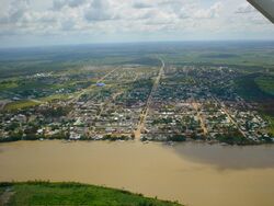
 منظر جوي لـ سان خوسيه دل غواڤيارى | |
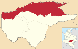
 موقع بلدية وبلدة سان خوسيه دل غواڤيارى في محافظة گواڤيارى في كولومبيا. | |
| الإحداثيات: 2°34′N 72°38′W / 2.567°N 72.633°W | |
| Country | |
| Region | Amazon Region |
| المحافظة | محافظة گواڤيارى |
| تأسست | 1960 |
| الحكومة | |
| • العمدة | Ramón Rojas Guevara |
| المساحة | |
| • بلدية وبلدة | 16٬769 كم² (6٬475 ميل²) |
| • الحضر | 6٫17 كم² (2٫38 ميل²) |
| المنسوب | 185 m (607 ft) |
| التعداد | |
| • بلدية وبلدة | 52٬815 |
| • الكثافة | 3٫1/km2 (8٫2/sq mi) |
| • Urban | 36٬254 |
| • الكثافة الحضرية | 5٬900/km2 (15٬000/sq mi) |
| صفة المواطن | Guaviarenses |
| منطقة التوقيت | UTC-05 (Colombia Standard Time) |
| Postal code | 950001-9 |
| مفتاح الهاتف | 57 + 9 |
| Climate | Am |
| الموقع الإلكتروني | Official website (in إسپانية) |
سان خوسيه دل گواڤيارى ( San José del Guaviare ؛ النطق الإسپاني: [saŋ xoˈse ðel ɣwaˈβja.ɾe]) هي بلدة وبلدية في in Colombia, capital of the department of Guaviare by the نهر گواڤيارى. It is home to some of the deisolated Nunak people.
. . . . . . . . . . . . . . . . . . . . . . . . . . . . . . . . . . . . . . . . . . . . . . . . . . . . . . . . . . . . . . . . . . . . . . . . . . . . . . . . . . . . . . . . . . . . . . . . . . . . . . . . . . . . . . . . . . . . . . . . . . . . . . . . . . . . . . . . . . . . . . . . . . . . . . . . . . . . . . . . . . . . . . . .
التاريخ
Especially on the banks of the rivers in the region, indigenous peoples of the Guahibo linguistic families (such as the Guayaberos and Sikuani ) inhabited. The region was also home to peoples of the Arawak (such as the Piapoco and Kurripakos ) and Tucano (such as the Cubeos ) families, as well as the Tinigua and Puinave , those who lived from hunting , fishing , and horticulture. The interior of the jungle has been inhabited for centuries by the nukak , formerly known as macú.
الجغرافيا
San José del Guaviare, the capital of the department of Guaviare , is located in the northern part of this political-administrative division, in an area of 42,327 square kilometers. The municipal seat is 175 meters above sea level , approximately 400 km south of the city of Bogotá , with coordinates 2°34′15″N 72°38′25″W
Its terrain is mainly flat, corresponding to the transition between the Orinoquía and the Amazon , and is irrigated by several watercourses, among which the Guaviare and Guayabero rivers stand out , which also serve to communicate with nearby populations, inside and outside. from the Department. The Inírida river serves to delimit the southeast of the municipality.
Most of the territory is made up of tropical humid forests and gallery forests , although in the northern part there are natural savannahs. In the areas of influence of the roads and trails that start from the municipal capital and in various colonization points, there are intervened lands where the forests have been replaced by various crops or pastures.
It shares with the department of Meta the Serranía de la Macarena natural national park ; with the department of Caquetá , the Chiribiquete national natural park and with the municipality of El Retorno, the Nukak natural reserve. The reservation of the Nukak covers more than 20% of the extension of the municipality. It also has several reservations of the Guayabero , Sikuani , Tucano , Desano, Piratapuyo and Kurripako indigenous people.
There are attractive landscapes of singular beauty in the region, such as the Chiribiquete mountain range, declared a natural national park, which has almost vertical walls of spectacular appearance, and numerous rivers with their rapids surrounded by thick jungle; The mountains of San José and La Lindosa with their cave paintings, the rocky outcrops of the "City of Stone", Natural Bridges and Los Túneles, Cascada el Diamante, the Inírida and Espejo rivers, the Tomachipán rapids stand out as tourist attractions. , the savannas of La Fuga, Laguna Damas del Nare where its spectacular sighting of the freshwater dolphin (Inia geoffrensis) makes it a paradise for Toninas, the Cascada del Amor and Las Delicias, the Rincón de los Toros and the spas of the natural wells, Agua Bonita, Trankilandia and Flintstone.
المراجع
- ^ INFORMACIÓN CAPITAL
- ^ SAN JOSÉ DEL GUAVIARE: Municipality in Guaviare, Citypopulation.de
وصلات خارجية
- Video of tourist areas around San José del Guaviare
- (in إسپانية) San José del Guaviare official website
- Encyclopædia Britannica; San José del Guaviare
- (in إسپانية) Sistema de Información Ambiental Territorial de la Amazonia colombiana SIAT-AC


