ساخور (بلدة)
Tsakhur
Цахур ЦIaIх | |
|---|---|
Selo | |
 | |
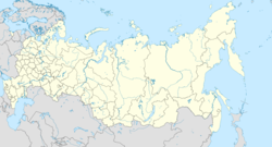
| الإحداثيات: 41°39′N 47°08′E / 41.650°N 47.133°E[1] | |
| Country | |
| Region | |
| District | Rutulsky District |
| التعداد (2010) | |
| • الإجمالي | 476 |
| منطقة التوقيت | UTC+3:00 |
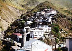
Tsakhur (روسية: Цахур; Tsakhur: ЦIaIх) is a rural locality (a selo) and the administrative centre of Tsakhurskoye Rural Settlement, Rutulsky District, Republic of Dagestan, Russia. Population: 476 (تعداد 2010);[2] 329 (تعداد 2002);[3] 326 (تعداد 1989).[4] There are 4 streets.[5]
الجغرافيا
Tsakhur is located in the valley of the Samur river, 35 km northwest of Rutul (the district's administrative centre) by road. Muslakh and Gelmets are the nearest rural localities.[6]
الأعراق
[[ساخور (شعب)|الساخور هم سكان البلدة.
أشهر السكان
- Abdulla Mukhtarov (Doctor of Physical and Mathematical Sciences, associate Professor, Professor of the Physics Department of the Azerbaijan State University)
- Selim Dzhafarov (Caucasian scientist, linguist and Turkologist, professor at Baku State University)
المراجع
- ^ Село Цахур на карте
- ^ Russian Federal State Statistics Service (2011). "Всероссийская перепись населения 2010 года. Том 1". Всероссийская перепись населения 2010 года (2010 All-Russia Population Census) (in Russian). Federal State Statistics Service. Retrieved June 29, 2012.
{{cite web}}: Invalid|ref=harv(help); Unknown parameter|trans_title=ignored (|trans-title=suggested) (help)CS1 maint: unrecognized language (link) - ^ Федеральная служба государственной статистики (Federal State Statistics Service) (2004-05-21). "Численность населения России, субъектов Российской Федерации в составе федеральных округов, районов, городских поселений, сельских населённых пунктов – районных центров и сельских населённых пунктов с населением 3 тысячи и более человек[[Category:Articles containing روسية-language text]] (Population of Russia, its federal districts, federal subjects, districts, urban localities, rural localities—administrative centers, and rural localities with population of over 3,000)". Всероссийская перепись населения 2002 года (All-Russia Population Census of 2002) (in Russian). Federal State Statistics Service. Retrieved 2008-07-25.
{{cite web}}: URL–wikilink conflict (help)CS1 maint: unrecognized language (link) - ^ "Всесоюзная перепись населения 1989 г. Численность наличного населения союзных и автономных республик, автономных областей и округов, краёв, областей, районов, городских поселений и сёл-райцентров.[[Category:Articles containing روسية-language text]] (All Union Population Census of 1989. Present population of union and autonomous republics, autonomous oblasts and okrugs, krais, oblasts, districts, urban settlements, and villages serving as district administrative centers.)". Всесоюзная перепись населения 1989 года (All-Union Population Census of 1989) (in Russian). Demoscope Weekly (website of the Institute of Demographics of the State University—Higher School of Economics. 1989. Retrieved 2007-12-13.
{{cite web}}: Italic or bold markup not allowed in:|publisher=(help); URL–wikilink conflict (help)CS1 maint: unrecognized language (link) - ^ Село Цахур на карте
- ^ Расстояние от Цахура до Рутула 35 км
This article contains content from Wikimedia licensed under CC BY-SA 4.0. Please comply with the license terms.

