زلزال پيچيلمو 2010
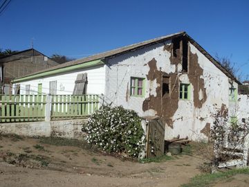
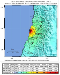
 Above: House damaged by the Pichilemu earthquake, in the epicentre town, as seen on 16 April 2011. Below: Pichilemu earthquake shakemap produced by the United States Geological Survey | |
 | |
| الوقت UTC | ?? |
|---|---|
| المقدار | 6.9 Mw[1][2] 6.3 ML[2] |
| العمق | 33.1 kilometres (20.6 mi)*[2] |
| المركز | Pichilemu, Chile 34°18′04″S 72°07′48″W / 34.301°S 72.13°W[2] |
| المناطق المتأثرة | Chile Argentina |
| أقصى شدة | MM X |
| ذروة التسارع | 0.086g (Curicó, Maule)[3] |
| التسونامي | Yes |
| الخسائر | 1 killed |
زلزال پيچيلمو 2010 (إسپانية: Terremoto de Pichilemu de 2010), also known as the Libertador O'Higgins earthquake, was a 6.9 MW intraplate earthquake that struck Chile's O'Higgins Region on 11 March 2010. The earthquake was centred 15 kilometres (9.3 mi) northwest of the city of Pichilemu, according to the University of Chile Seismological Service.
يوم السبت الماضي ، تشيلي كانت قد تعرضت ل زلزال بقوة 8.8. العديد من المدن الساحلية قد تضررت من امواج المد ، و بيشليميو كان سكانها قد فوجئوا بالامواج العاتية التي دمرت معظم المنطقة الساحلية ' و قد وصلت أيضا إلى ساحة المدينة.
پيچيلمو ، وهذا يعني في Mapudungun اللغة غابة صغيرة« ، هي واحدة من المدن الاكثر شهرة ,وهى منتجع تشيلي في منطقة وسط شيلي. فقد زاره مرات عديدة من قبل اشخاص من كافة انحاء العالم ، وذلك لأن شاطئ بونتا دي لوبوس يعتبر واحدا من أفضل الشواطىء لممارسة ركوب الأمواج في جميع أنحاء العالم
Central Pichilemu was not severely damaged by the earthquake, but the tsunami caused significant destruction. The Fisherman Creek, located in front of the beach, was completely destroyed, and its machines are now unusable. Most of the Agustín Ross architecture that characterized the city, three of them being National Monuments of Chile, were damaged. The Agustín Ross Mirador, a famous location in front of the beach, located less than 200 meters from the Fisherman Creek, was completely destroyed. Its famous balustrades were washed away or thrown asunder. Many restaurants, kiosks and a circus were affected by the tsunami.
The rural parts of Pichilemu, like Ciruelos, Rodeillos and Espinillos feature houses constructed from adobe. Many were more than 100-years old, and were destroyed or are now uninhabitable.
The most powerful aftershock was produced almost 40 kilometers in front of the coast of Pichilemu, at the 03:10 local time (07:10 UTC) in March 2, with an intensity of 5.5 in the Richter scale, according to the USGS.
The Intendant of the O'Higgins Region, Juan Núñez, had a meeting with the Governor of the Cardenal Caro Province, Loreto Puebla, the Mayor of Pichilemu, Roberto Córdova, and naval and military authorities, juntas de vecinos representatives. They decided to leave the Carabineros police force to maintain the security of the city.
. . . . . . . . . . . . . . . . . . . . . . . . . . . . . . . . . . . . . . . . . . . . . . . . . . . . . . . . . . . . . . . . . . . . . . . . . . . . . . . . . . . . . . . . . . . . . . . . . . . . . . . . . . . . . . . . . . . . . . . . . . . . . . . . . . . . . . . . . . . . . . . . . . . . . . . . . . . . . . . . . . . . . . . .
See also
References
- ^ خطأ استشهاد: وسم
<ref>غير صحيح؛ لا نص تم توفيره للمراجع المسماةUSGS - ^ أ ب ت ث خطأ استشهاد: وسم
<ref>غير صحيح؛ لا نص تم توفيره للمراجع المسماةSSN - ^ "Station Lists". United States Geological Survey. 2010. Archived from the original on 25 February 2013. Retrieved 20 May 2012.
{{cite web}}: Unknown parameter|deadurl=ignored (|url-status=suggested) (help)
للاستزادة
- Farías, Marcelo; Comte, Diana; Roecker, Steven; Carrizo, Daniel; Pardo, Mario (2011). "Crustal extensional faulting triggered by the 2010 Chilean earthquake: The Pichilemu Seismic Sequence". Tectonics. 30 (6): n/a–n/a. Bibcode:2011Tecto..30.6010F. doi:10.1029/2011TC002888. ISSN 0278-7407.
- Ryder, Isabelle; Rietbrock, Andreas; Kelson, Keith; Bürgmann, Roland; Floyd, Michael; Socquet, Anne; Vigny, Christophe; Carrizo, Daniel (2012). "Large extensional aftershocks in the continental forearc triggered by the 2010 Maule earthquake, Chile". Geophysical Journal International. 188 (3): 879–890. Bibcode:2012GeoJI.188..879R. doi:10.1111/j.1365-246X.2011.05321.x. ISSN 0956-540X.
- Aron, Felipe; Allmendinger, Richard W.; Cembrano, José; González, Gabriel; Yáñez, Gonzalo (2013). "Permanent fore-arc extension and seismic segmentation: Insights from the 2010 Maule earthquake, Chile". Journal of Geophysical Research: Solid Earth. 118 (2): 724–739. Bibcode:2013JGRB..118..724A. doi:10.1029/2012JB009339. ISSN 2169-9313.
- Lange, Dietrich; Tilmann, Frederik; Barrientos, Sergio E.; Contreras-Reyes, Eduardo; Methe, Pascal; Moreno, Marcos; Heit, Ben; Agurto, Hans; Bernard, Pascal; Vilotte, Jean-Pierre; Beck, Susan (2012). "Aftershock seismicity of the 27 February 2010 Mw 8.8 Maule earthquake rupture zone". Earth and Planetary Science Letters. 317–318: 413–425. Bibcode:2012E&PSL.317..413L. doi:10.1016/j.epsl.2011.11.034. ISSN 0012-821X.
- Quezada, Jorge; Jaque, Edilia; Belmonte, Arturo; Fernández, Alfonso; Vásquez, Daniela; Martínez, Carolina (2010). "Movimientos cosísmicos verticales y cambios geomorfológicos generados durante el terremoto Mw=8,8 del 27 de febrero de 2010 en el centro-sur de Chile" (PDF). Geográfica del Sur (in Spanish). 2: 11–45.
{{cite journal}}: Unknown parameter|trans_title=ignored (|trans-title=suggested) (help)CS1 maint: unrecognized language (link)
وصلات خارجية
- Story of the handover ceremony, CIPER Chile (archived version) (بالإسپانية)
- "Sismogénesis, proceso de ruptura y réplicas del mega terremoto del Maule 2010", article published by the Faculty of Mathematical and Physical Sciences of the University of Chile. (بالإسپانية)
- Pages using gadget WikiMiniAtlas
- CS1 errors: unsupported parameter
- EQ articles needing UTC timestamp
- Convert invalid options
- Coordinates on Wikidata
- EQ articles waiting for ISC event id
- EQ articles needing ANSS url
- EQ articles needing 'local-date'
- EQ articles needing 'local-time'
- Pages using infobox earthquake with unknown parameters
- Articles containing إسپانية-language text
- Pages using Lang-xx templates
- Pages with empty portal template
- Earthquakes in Chile
- 2010 earthquakes
- 2010 in Chile
- 2010 Chile earthquake
- History of Pichilemu
- History of O'Higgins Region
- 2010 tsunamis