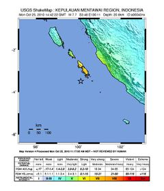
زلزال سومطرة أكتوبر 2010

| |
| التاريخ | 14:42:22، 25 أكتوبر 2010 (UTC) |
|---|---|
| المقدار | 7.7 Mw |
| العمق | 12.8كم |
| موقع مركز الزلزال | 3°27′50″S 100°05′02″E / 3.464°S 100.084°ECoordinates: 3°27′50″S 100°05′02″E / 3.464°S 100.084°E[1][2] |
| البلدان/ المناطق المتأثرة |
إندونيسيا |
| الضحايا | |
زلزال سومطرة أكتوبر 2010 حدث في 25 أكتوبر 2010 وبلغت قوته 7.7[1] في جزيرة سومطرة، إندونيسيا.
. . . . . . . . . . . . . . . . . . . . . . . . . . . . . . . . . . . . . . . . . . . . . . . . . . . . . . . . . . . . . . . . . . . . . . . . . . . . . . . . . . . . . . . . . . . . . . . . . . . . . . . . . . . . . . . . . . . . . . . . . . . . . . . . . . . . . . . . . . . . . . . . . . . . . . . . . . . . . . . . . . . . . . . .
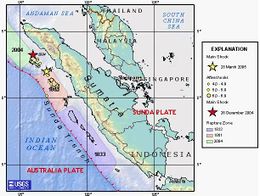
خلفية تكتونية
التوابع
- 5.0 – 25 أكتوبر 15:21:12 UTC[6]
- 6.1 – 25 أكتوبر 19:37:30 UTC[7]
- 4.9 – 25 أكتوبر 22:10:03 UTC[8]
- 6.2 – 25 أكتوبر 22:59:53 UTC[9]
- 5.3 – 26 أكتوبر 10:51:25 UTC[10]
- 5.3 – 26 أكتوبر 11:33:21 UTC[11]
- 5.0 – 26 أكتوبر 19:40:41 UTC[12]
انظر أيضا
المصادر
- ^ أ ب "Magnitude 7.5 – KEPULAUAN MENTAWAI REGION, INDONESIA". earthquake.usgs.gov. USGS. Retrieved 2010-10-26.
- ^ "Google Maps". maps.google.com. Google. Retrieved 2010-10-26.
- ^ Creagh, Sunanda. "Reuters". Reuters. Retrieved 2010-10-26.
- ^ "Xinhua". News.xinhuanet.com. Retrieved 2010-10-26.
- ^ Andy Saputra (2010-10-26). "At least 112 dead, more than 500 missing after Indonesia quake". cnn.com. CNN. Retrieved 2010-10-26.
- ^ (AP) – 1 day ago. "The Associated Press: 7.7-magnitude quake hits off Indonesian island". Google.com. Retrieved 2010-10-26.
{{cite web}}: CS1 maint: numeric names: authors list (link) - ^ Agence France-Presse October 25, 2010. "Major 7.7 quake strikes Indonesia". montrealgazette.com. Montreal Gazette. Retrieved 2010-10-26.
{{cite web}}: CS1 maint: numeric names: authors list (link) - ^ "Magnitude 4.9 – KEPULAUAN MENTAWAI REGION, INDONESIA". earthquake.usgs.gov. USGS. Retrieved 2010-10-26.
- ^ "Magnitude 6.2 – KEPULAUAN MENTAWAI REGION, INDONESIA". earthquake.usgs.gov. USGS. Retrieved 2010-10-26.
- ^ "Magnitude 5.3 – SOUTHWEST OF SUMATRA, INDONESIA". earthquake.usgs.gov. USGS. Retrieved 2010-10-26.
- ^ "Magnitude 5.3 – KEPULAUAN MENTAWAI REGION, INDONESIA". earthquake.usgs.gov. USGS. Retrieved 2010-10-26.
- ^ "Magnitude 5.0 – SOUTHWEST OF SUMATRA, INDONESIA". earthquake.usgs.gov. USGS. Retrieved 2010-10-26.
الكلمات الدالة:
