خان التجار، (جبل طابور)
| Khan al-Tujjar | |
|---|---|
[خان التجار ] | |
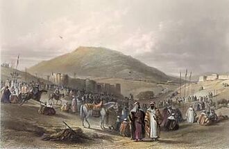
 A fair at Khan al-Tujjar around 1850, by W. H. Bartlett | |
 | |
| الأسماء السابقة | Khan al-Tujjar (in Arabic) |
| الأسماء البديلة | The Merchant's Caravansary[1] Suq al-Khan |
| معلومات عامة | |
| النوع | Caravanserai |
| الطراز المعماري | Ottoman |
| الموقع | Mount Tabor, Israel |
| الإحداثيات | 32°43′17.46″N 35°24′40.67″E / 32.7215167°N 35.4112972°E |
| Palestine grid | 187/236 |
| اكتمل | 1581 |
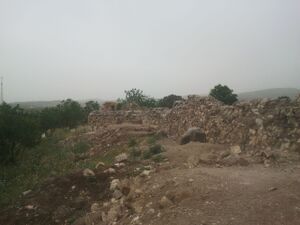
خان التجار (ويدعى أيضاً سوق الخان) يقع على سفح جبل طابور، مقابل مدخل بيت كشت. الخان أسسه الصدر الأعظم سنان پاشا حوالي 1581.[2][3] السبب المعظى للتأسيسه كان انعدام الأمن للتجار والحجيج، وقد قيل أن بناء الخان سيجعل المكان "مأهولاً ومزروعاً".[3]
. . . . . . . . . . . . . . . . . . . . . . . . . . . . . . . . . . . . . . . . . . . . . . . . . . . . . . . . . . . . . . . . . . . . . . . . . . . . . . . . . . . . . . . . . . . . . . . . . . . . . . . . . . . . . . . . . . . . . . . . . . . . . . . . . . . . . . . . . . . . . . . . . . . . . . . . . . . . . . . . . . . . . . . .
التاريخ

خان التجار من 1871-77 PEF Survey of Palestine
انظر أيضاً
الهامش
- ^ Palmer, 1881, p. 128
- ^ Khan al-Tujjar Archived 2012-04-26 at the Wayback Machine Archnet Digital Library.
- ^ أ ب Sharon, 1999, p. 230
ببليوگرافيا
- Buckingham, J.S. (1821). Travels in Palestine Through the Countries of Bashan and Gilead, East of the River Jordan, Including a Visit to the Cities of Geraza and Gamala in the Decapolis. London: Longman. Cited in Petersen, 2001, p. 200.
- Conder, C.R.; Kitchener, H.H. (1881). The Survey of Western Palestine: Memoirs of the Topography, Orography, Hydrography, and Archaeology. Vol. 1. London: Committee of the Palestine Exploration Fund.
- Egmont, van; Heyman, John (1759). Travels through part of Europe, Asia Minor, the islands of the archipelago, Syria, Palestine, Egypt, Mount Sinai, &c. giving a particular account of the most remarkable places. Vol. 2. London: L. Davis and C. Reymers.
{{cite book}}: Check|authorlink1=value (help) - Guérin, V. (1880). Description Géographique Historique et Archéologique de la Palestine (in French). Vol. 3: Galilee, pt. 1. Paris: L'Imprimerie Nationale.
{{cite book}}: CS1 maint: unrecognized language (link) - Karmon, Y. (1960). "An Analysis of Jacotin's Map of Palestine" (PDF). Israel Exploration Journal. 10 (3, 4): 155–173, 244–253.
- Mariti, G. (1792). Travels Through Cyprus, Syria, and Palestine; with a General History of the Levant. Vol. 1. Dublin: P. Byrne.
{{cite book}}: Check|authorlink=value (help) - Palmer, E.H. (1881). The Survey of Western Palestine: Arabic and English Name Lists Collected During the Survey by Lieutenants Conder and Kitchener, R. E. Transliterated and Explained by E.H. Palmer. Committee of the Palestine Exploration Fund.
- Petersen, Andrew (2001). A Gazetteer of Buildings in Muslim Palestine (British Academy Monographs in Archaeology). Vol. 1. Oxford University Press. ISBN 978-0-19-727011-0. (pp. 197–200)
- Robinson, E.; Smith, E. (1841). Biblical Researches in Palestine, Mount Sinai and Arabia Petraea: A Journal of Travels in the year 1838. Vol. 3. Boston: Crocker & Brewster. Cited in Petersen, 2001, p 200.
- Schölch, Alexander (1993). Palestine in Transformation, 1856-1882: Studies in Social, Economic, and Political Development. Institute for Palestine Studies. ISBN 0-88728-234-2.
- Sharon, M. (1999). Corpus Inscriptionum Arabicarum Palaestinae, B-C. Vol. 2. BRILL. ISBN 90-04-11083-6.
- Stephan, Stephan H. (1937). "Evliya Tshelebi's Travels in Palestine, IV". The Quarterly of the Department of Antiquities in Palestine. 6: 84–97.
- Thomson, W.M. (1859). The Land and the Book: Or, Biblical Illustrations Drawn from the Manners and Customs, the Scenes and Scenery, of the Holy Land. Vol. 2 (1 ed.). New York: Harper & brothers.
وصلات خارجية
- Khan al-Tujjar, Nablus, Palestine, archnet.org
- Survey of Western Palestine, Map 6: IAA, Wikimedia commons
