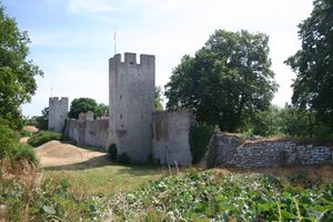
غوتلند
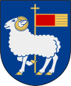 Coat of arms | |
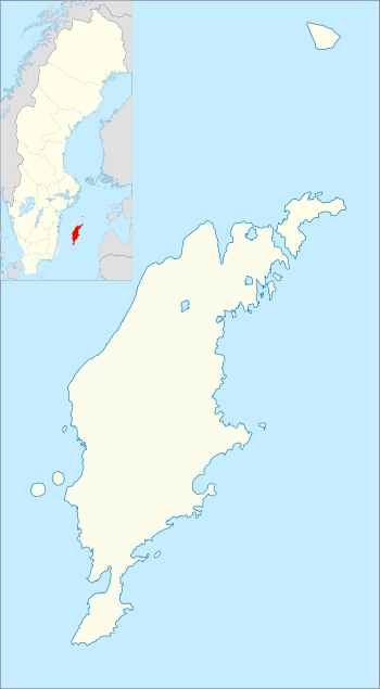 | |
| الجغرافيا | |
|---|---|
| الموقع | بحر البلطيق |
| الإحداثيات | 57°30′N 18°30′E / 57.500°N 18.500°E |
| الأرخبيل | أرخبيل سليتى |
| إجمالي الجزر | 14 كبيرة + عدد من الجزر الأصغر |
| الجزر الرئيسية | Gotland, Fårö, Gotska Sandön, Stora Karlsö, Lilla Karlsö, فوريلن |
| المساحة | 3،183.7 km2 (1،229.2 sq mi) |
| الطول | 176 km (109٫4 mi) |
| العرض | 52 km (32٫3 mi) |
| الخط الساحلي | 800 km (500 mi) (including Fårö) |
| أعلى منسوب | 82 m (269 ft) |
| أعلى نقطة | Lojsta hed |
| الإدارة | |
| المقاطعة | مقاطعة گوتلند |
| بلدية | منطقة گوتلند |
| Largest settlement | ڤيسبي (pop. 23,600[1]) |
| السكان | |
| التعداد | 58,595[2] (2017) |
| الكثافة السكانية | 18٫4 /km2 (47٫7 /sq mi) |
| الاسم الرسمي | Gotland, east coast |
| التوصيف | 5 ديسمبر 1974 |
| الرقم المرجعي | 21[3] |
جزيرة گوتلند Gotland (/ˈɡɒtlənd/, النطق السويدي: [ˈɡɔtland] (![]() استمع) or [ˈɡɔlland]), هي جزيرة سويدية تقع في بحر البلطيق على بعد 90 كلم من البر السويدي. وهي أيضاً مركز ومقاطعة وبلدية و أبرشية. المركز يضم جزر Fårö and Gotska Sandön to the north, as well as the Karlsö Islands (Lilla and Stora) to the west. وعاصمتها هي مدينة ڤيسبي، تعتبر هي أكبر جزيرة ببحر البلطيق, حيث تبلغ مساحتها حوالي 3140 كلم مربع , ويبلغ عدد سكانها 58,595,[2] of which about 23,600 live in Visby, the main town.[1] Outside Visby, there are minor settlements and a mainly rural population. The island of Gotland and the other areas of the province of Gotland make up less than one percent of Sweden's total land area. The county formed by the archipelago is the second smallest by area and is the least populated in Sweden. In spite of the small size due to its narrow width, the driving distance between the furthermost points of the populated islands is about 170 كيلومتر (110 mi).[4]
استمع) or [ˈɡɔlland]), هي جزيرة سويدية تقع في بحر البلطيق على بعد 90 كلم من البر السويدي. وهي أيضاً مركز ومقاطعة وبلدية و أبرشية. المركز يضم جزر Fårö and Gotska Sandön to the north, as well as the Karlsö Islands (Lilla and Stora) to the west. وعاصمتها هي مدينة ڤيسبي، تعتبر هي أكبر جزيرة ببحر البلطيق, حيث تبلغ مساحتها حوالي 3140 كلم مربع , ويبلغ عدد سكانها 58,595,[2] of which about 23,600 live in Visby, the main town.[1] Outside Visby, there are minor settlements and a mainly rural population. The island of Gotland and the other areas of the province of Gotland make up less than one percent of Sweden's total land area. The county formed by the archipelago is the second smallest by area and is the least populated in Sweden. In spite of the small size due to its narrow width, the driving distance between the furthermost points of the populated islands is about 170 كيلومتر (110 mi).[4]
گوتلند هي جزء مندمج بالكامل في السويد بدون أي استقلال ذاتي، على العكس من العديد من مجموعات الجزر الأخرى في أوروپا. Historically there was a linguistic difference between the archipelago and the mainland with Gutnish being the native language. In recent centuries, Swedish took over almost entirely and the island is virtually monolingually Swedish in modern times. The archipelago is a very popular domestic tourist destination for mainland Swedes, with the population rising to very high numbers during summers. Among reasons include the sunny climate and the extensive shoreline on mild water. During summer Visby hosts the political event Almedalen Week followed by the Medieval Week, further boosting visitor numbers. In winter, Gotland usually remains surrounded by ice-free water and has mild weather.
Gotland has been inhabited since approximately 7200 BC.[5] Its location in the centre of the Baltic Sea has historically given it great strategic importance. The island's main sources of income are agriculture, food processing, tourism, information technology services, design, and some heavy industry such as concrete production from locally mined limestone.[6] From a military viewpoint, it occupies a strategic location in the Baltic Sea.
أصل الاسم
The name of Gotland is closely related to that of the Geats and Goths.[7]
التاريخ
من قبل التاريخ إلى عصر الڤايكنگ
The island was the home of the Gutes, and sites such as the Ajvide Settlement show that it has been occupied since prehistory.[8] A DNA study conducted on the 5,000-year-old skeletal remains of three Middle Neolithic seal hunters from Gotland showed that they were related to modern-day Finns, while a farmer from Gökhem parish in Västergötland on the mainland was found to be more closely related to modern-day Mediterraneans. This is consistent with the spread of agricultural peoples from the Middle East at about that time.[9]

الجغرافيا

Gotland is Sweden's largest island, and it is the largest island fully encompassed by the Baltic Sea (with Denmark's Zealand at the Baltic's edge).[10][11][12][13] With its total area of 3،183.7 km2 (1،229.2 sq mi) the island of Gotland and the other areas of the province of Gotland make up 0.8% of Sweden's total land area.[14] The province includes the small islands of Fårö and Gotska Sandön to the north, as well as the Karlsö Islands, (Lilla and Stora) to the west, which are even smaller. The island of Gotland has an area of 2،994 km2 (1،156 sq mi), whereas the province has 3،183.7 km2 (1،229.2 sq mi) [3،151 km2 (1،217 sq mi) of land excluding the lakes and rivers].[15] The population is 57,221,[2] of which about 23,600 live in Visby, the seat of the municipality as well as the capital of the county.[1] About two-fifths of the island's population live in Visby.
Gotland is located about 90 km (56 mi) east of the Swedish mainland and about 130 km (81 mi) from the Baltic states, Latvia being the nearest. Gotland is the name of the main island, but the adjacent islands are generally considered part of Gotland and the Gotlandic culture:
- Furillen
- Fårö
- Gotska Sandön, a National park of Sweden
- The Karlsö Islands (Stora Karlsö and Lilla Karlsö)
- Laus holmar
- Ytterholmen
- Östergarnsholm
There are several shallow lakes located near the shores of the island. The biggest is Lake Bästeträsk, located near Fleringe in the northern part of Gotland. The Hoburg Shoal bird reserve is situated on the southern tip of the island.[16] The highest point of the island is Lojsta Hed which stands 82 m (269 ft) above sea level.
Settlements besides Visby include:
Of these, Hemse is the largest settlement in southern Gotland and along with Roma the two largest inland villages. Burgsvik is the southernmost locality and Fårösund the northernmost. The island of Fårö is permanently settled, but with only a few hundred year-round residents and lacks a permanent fixed link to the main island. Residents are depending on an around the clock, free of charge, car ferry for transportation over a strait roughly 1.3 km (0.81 mi) wide, taking about eight minutes.[17][18] Fårö may get connected to the main island with a bridge in the future, but the project has had plenty of delays related to funding.[19][20] At the closest point, the two islands are separated by less than 500 متر (1،600 ft), although that is at a distance from road connections.
Slite is the largest settlement on Gotland's sparsely populated east coast.
المناخ
Gotland has a semi-continental variety of a marine climate (Cfb). This results in larger seasonal differences than typical of marine climates in spite of it being surrounded by the Baltic Sea for large distances in all directions. This is due to strong continental winds travelling over the sea from surrounding great landmasses. Seasonal temperature variation is smaller in more isolated places on the island such as Hoburgen or Östergarnsholm, having warmer autumn and winter, but are cooler during spring and summer days. Seasonal lag being exceptionally strong in the weather station Östergarnsholm. As an example, December is warmer than March with temperature lows being similar to April. August is typically the warmest month, an unusual occurrence in Swedish sites. In capital Visby, July and August temperatures tend to be quite even.
Since winters usually remain just above freezing and brackish water remaining liquid longer than freshwater, the sea remains ice-free all year round, except during rare extreme cold waves. The last time the whole passage from the mainland to Gotland froze was in 1987 when icebreakers were used to maintain passenger and goods traffic to the island.[21]
| بيانات المناخ لـ مطار ڤيسبي (2002–2020 averages, extremes since 1901) | |||||||||||||
|---|---|---|---|---|---|---|---|---|---|---|---|---|---|
| الشهر | ينا | فب | مار | أبر | ماي | يون | يول | أغس | سبت | أكت | نوف | ديس | السنة |
| القصوى القياسية °س (°ف) | 10.2 (50.4) |
12.9 (55.2) |
18.6 (65.5) |
25.2 (77.4) |
27.7 (81.9) |
31.4 (88.5) |
33.7 (92.7) |
32.9 (91.2) |
29.0 (84.2) |
20.9 (69.6) |
14.9 (58.8) |
12.5 (54.5) |
33.7 (92.7) |
| متوسط القصوى اليومية °س (°ف) | 1.8 (35.2) |
1.8 (35.2) |
4.6 (40.3) |
10.2 (50.4) |
15.6 (60.1) |
19.4 (66.9) |
21.9 (71.4) |
21.5 (70.7) |
17.1 (62.8) |
11.0 (51.8) |
6.9 (44.4) |
3.9 (39.0) |
11.3 (52.4) |
| المتوسط اليومي °س (°ف) | −0.3 (31.5) |
−0.5 (31.1) |
1.3 (34.3) |
5.2 (41.4) |
10.6 (51.1) |
14.8 (58.6) |
17.7 (63.9) |
17.4 (63.3) |
13.6 (56.5) |
8.3 (46.9) |
4.9 (40.8) |
2.0 (35.6) |
7.9 (46.3) |
| متوسط الدنيا اليومية °س (°ف) | −2.4 (27.7) |
−2.7 (27.1) |
−2.1 (28.2) |
1.1 (34.0) |
5.5 (41.9) |
10.2 (50.4) |
13.4 (56.1) |
13.3 (55.9) |
10.0 (50.0) |
5.5 (41.9) |
2.9 (37.2) |
0.1 (32.2) |
4.6 (40.2) |
| متوسط الدنيا °س (°ف) | −12.7 (9.1) |
−11.0 (12.2) |
−10.9 (12.4) |
−5.9 (21.4) |
−1.7 (28.9) |
3.1 (37.6) |
7.6 (45.7) |
6.5 (43.7) |
3.3 (37.9) |
−2.2 (28.0) |
−3.8 (25.2) |
−7.8 (18.0) |
−14.6 (5.7) |
| الصغرى القياسية °س (°ف) | −25.0 (−13.0) |
−25.4 (−13.7) |
−23.5 (−10.3) |
−12.7 (9.1) |
−7.8 (18.0) |
−1.0 (30.2) |
2.9 (37.2) |
1.1 (34.0) |
−2.9 (26.8) |
−6.0 (21.2) |
−11.5 (11.3) |
−22.2 (−8.0) |
−25.4 (−13.7) |
| متوسط تساقط الأمطار mm (inches) | 46.5 (1.83) |
32.0 (1.26) |
27.9 (1.10) |
20.2 (0.80) |
28.2 (1.11) |
39.8 (1.57) |
64.8 (2.55) |
58.6 (2.31) |
40.1 (1.58) |
57.4 (2.26) |
60.9 (2.40) |
57.8 (2.28) |
534.2 (21.05) |
| متوسط عمق الثلج الكثيف cm (inches) | 15 (5.9) |
13 (5.1) |
8 (3.1) |
1 (0.4) |
0 (0) |
0 (0) |
0 (0) |
0 (0) |
0 (0) |
0 (0) |
5 (2.0) |
7 (2.8) |
21 (8.3) |
| Mean monthly ساعات سطوع الشمس | 37 | 70 | 167 | 261 | 322 | 331 | 313 | 265 | 200 | 103 | 42 | 31 | 2٬142 |
| Source 1: [22] | |||||||||||||
| Source 2: [23] | |||||||||||||
| Climate data for Visby | |||||||||||||
|---|---|---|---|---|---|---|---|---|---|---|---|---|---|
| Month | Jan | Feb | Mar | Apr | May | Jun | Jul | Aug | Sep | Oct | Nov | Dec | Year |
| Average sea temperature °C (°F) | 2.9 |
2.3 |
1.8 |
3.4 |
7.7 |
14.1 |
18.1 |
18.6 |
16.0 |
11.7 |
7.8 |
5.3 |
9.2 |
| Mean daily daylight hours | 7.0 | 10.0 | 12.0 | 15.0 | 17.0 | 18.0 | 17.0 | 15.0 | 13.0 | 10.0 | 8.0 | 7.0 | 12.4 |
| Average Ultraviolet index | 0 | 1 | 2 | 4 | 5 | 6 | 6 | 5 | 4 | 2 | 1 | 0 | 3 |
| Source: Weather Atlas[24] | |||||||||||||
| بيانات المناخ لـ Fårösund (2002–2020 averages, extremes since 1995) | |||||||||||||
|---|---|---|---|---|---|---|---|---|---|---|---|---|---|
| الشهر | ينا | فب | مار | أبر | ماي | يون | يول | أغس | سبت | أكت | نوف | ديس | السنة |
| القصوى القياسية °س (°ف) | 10.8 (51.4) |
13.7 (56.7) |
17.1 (62.8) |
22.9 (73.2) |
27.1 (80.8) |
29.5 (85.1) |
30.8 (87.4) |
30.1 (86.2) |
25.6 (78.1) |
21.3 (70.3) |
15.8 (60.4) |
13.7 (56.7) |
30.8 (87.4) |
| متوسط القصوى اليومية °س (°ف) | 2.4 (36.3) |
2.2 (36.0) |
4.5 (40.1) |
9.0 (48.2) |
14.1 (57.4) |
18.5 (65.3) |
21.2 (70.2) |
20.9 (69.6) |
17.0 (62.6) |
11.1 (52.0) |
7.2 (45.0) |
4.3 (39.7) |
11.0 (51.9) |
| المتوسط اليومي °س (°ف) | 0.6 (33.1) |
0.4 (32.7) |
2.1 (35.8) |
5.9 (42.6) |
10.6 (51.1) |
15.1 (59.2) |
18.2 (64.8) |
18.0 (64.4) |
14.5 (58.1) |
9.1 (48.4) |
5.5 (41.9) |
2.7 (36.9) |
8.6 (47.4) |
| متوسط الدنيا اليومية °س (°ف) | −1.2 (29.8) |
−1.5 (29.3) |
−0.4 (31.3) |
2.7 (36.9) |
7.1 (44.8) |
11.7 (53.1) |
15.1 (59.2) |
15.1 (59.2) |
11.9 (53.4) |
7.1 (44.8) |
3.8 (38.8) |
1.0 (33.8) |
6.0 (42.9) |
| متوسط الدنيا °س (°ف) | −7.0 (19.4) |
−6.9 (19.6) |
−5.7 (21.7) |
−1.5 (29.3) |
2.3 (36.1) |
7.4 (45.3) |
11.4 (52.5) |
11.1 (52.0) |
7.2 (45.0) |
1.9 (35.4) |
−0.9 (30.4) |
−3.7 (25.3) |
−9.2 (15.4) |
| الصغرى القياسية °س (°ف) | −10.6 (12.9) |
−17.0 (1.4) |
−17.0 (1.4) |
−4.2 (24.4) |
−1.2 (29.8) |
4.8 (40.6) |
9.0 (48.2) |
8.4 (47.1) |
2.7 (36.9) |
−0.6 (30.9) |
−5.7 (21.7) |
−13.0 (8.6) |
−17.0 (1.4) |
| متوسط تساقط الأمطار mm (inches) | 29.7 (1.17) |
20.8 (0.82) |
21.7 (0.85) |
19.4 (0.76) |
26.3 (1.04) |
39.4 (1.55) |
53.7 (2.11) |
57.0 (2.24) |
38.1 (1.50) |
52.6 (2.07) |
49.6 (1.95) |
39.8 (1.57) |
448.1 (17.63) |
| Source 1: SMHI Open Data (temperature)[25] | |||||||||||||
| Source 2: SMHI Open Data (precipitation)[26] | |||||||||||||
| بيانات المناخ لـ Hemse (2002–2020 averages, extremes since 1945) | |||||||||||||
|---|---|---|---|---|---|---|---|---|---|---|---|---|---|
| الشهر | ينا | فب | مار | أبر | ماي | يون | يول | أغس | سبت | أكت | نوف | ديس | السنة |
| القصوى القياسية °س (°ف) | 8.5 (47.3) |
12.1 (53.8) |
17.9 (64.2) |
25.4 (77.7) |
28.7 (83.7) |
30.9 (87.6) |
33.7 (92.7) |
35.0 (95.0) |
29.0 (84.2) |
21.0 (69.8) |
14.6 (58.3) |
10.2 (50.4) |
35.0 (95.0) |
| متوسط القصوى اليومية °س (°ف) | 1.8 (35.2) |
2.3 (36.1) |
5.5 (41.9) |
11.3 (52.3) |
16.5 (61.7) |
20.4 (68.7) |
22.7 (72.9) |
22.1 (71.8) |
17.7 (63.9) |
11.4 (52.5) |
6.9 (44.4) |
3.7 (38.7) |
11.9 (53.3) |
| المتوسط اليومي °س (°ف) | −0.6 (30.9) |
−0.4 (31.3) |
1.5 (34.7) |
5.9 (42.6) |
10.7 (51.3) |
14.8 (58.6) |
17.6 (63.7) |
17.0 (62.6) |
13.1 (55.6) |
7.9 (46.2) |
4.5 (40.1) |
1.6 (34.9) |
7.8 (46.0) |
| متوسط الدنيا اليومية °س (°ف) | −3.0 (26.6) |
−3.0 (26.6) |
−2.6 (27.3) |
0.5 (32.9) |
4.8 (40.6) |
9.1 (48.4) |
12.4 (54.3) |
11.9 (53.4) |
8.5 (47.3) |
4.3 (39.7) |
2.1 (35.8) |
−0.6 (30.9) |
3.7 (38.7) |
| متوسط الدنيا °س (°ف) | −13.6 (7.5) |
−11.9 (10.6) |
−11.1 (12.0) |
−5.9 (21.4) |
−2.4 (27.7) |
2.0 (35.6) |
6.7 (44.1) |
4.9 (40.8) |
1.1 (34.0) |
−3.3 (26.1) |
−5.8 (21.6) |
−8.6 (16.5) |
−15.8 (3.6) |
| الصغرى القياسية °س (°ف) | −24.8 (−12.6) |
−25.7 (−14.3) |
−22.6 (−8.7) |
−10.8 (12.6) |
−7.0 (19.4) |
−1.4 (29.5) |
2.8 (37.0) |
0.3 (32.5) |
−6.8 (19.8) |
−9.4 (15.1) |
−15.1 (4.8) |
−22.0 (−7.6) |
−25.7 (−14.3) |
| متوسط تساقط الأمطار mm (inches) | 55.6 (2.19) |
40.2 (1.58) |
34.2 (1.35) |
24.5 (0.96) |
25.7 (1.01) |
40.6 (1.60) |
72.2 (2.84) |
70.8 (2.79) |
48.2 (1.90) |
61.8 (2.43) |
68.4 (2.69) |
66.6 (2.62) |
608.8 (23.96) |
| Source 1: SMHI [27] | |||||||||||||
| Source 2: SMHI [28] | |||||||||||||
الجيولوجيا
 مقالة مفصلة: جيولوجيا گوتلند


Gotland is made up of a sequence of sedimentary rocks of a Silurian age, dipping to the south-east. The main Silurian succession of limestones and shales comprises thirteen units spanning 200 إلى 500 m (660 إلى 1،640 ft) of stratigraphic thickness, being thickest in the south, and overlies a 75 إلى 125 m (246 إلى 410 ft) thick Ordovician sequence.[29]
It was deposited in a shallow, hot, and salty sea on the edge of an equatorial continent.[30] The water depth never exceeded 175 إلى 200 m (574 إلى 656 ft),[31] and became shallower over time as bioherm detritus and terrestrial sediments filled the basin. Reef growth started in the Llandovery, when the sea was 50 إلى 100 m (160 إلى 330 ft), and reefs continued to dominate the sedimentary record.[29] Some sandstones are present in the youngest rocks towards the south of the island, which represent sand bars deposited very close to the shoreline.[32]
The lime rocks have been weathered into characteristic karstic rock formations known as rauks. Fossils, mainly of crinoids, rugose corals and brachiopods, are abundant throughout the island; palæo-sea-stacks are preserved in places.[33]
الحكم
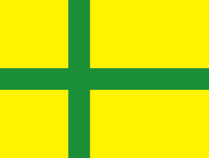
الأعلام
الثقافة

مشاهير گوتلند
مراجع في الثقافة الشعبية
أحداث رياضية
المنظمات الرياضية
انظر أيضاً
- ڤيسبي
- Vavle
- سكاندزا
- Gotlanders
- Old Gutnish
- Gutnish
- Gutasaga
- السويديون (قبيلة الجرمان)
- Goths
- اللغة القوطية
- الأبجدية القوطية
- Geats
- الدنماركيون (قبيلة الجرمان)
- اللغة البروتو-نرويجية
- نورس القديمة
- الإسكنديناڤ
- Norsemen
- Hanseatic League
- السويديون
- Sweden proper
- السويد
- الدنماركيون
- الدنمارك
- الدول الاسكندناڤية
- الشعوب الجرمانية
المصادر
- ^ أ ب ت "Gotland i siffror, pdf". www.gotland.se. Region Gotland. pp. 65–67. Retrieved 13 June 2014.
- ^ أ ب ت Statistics Sweden (as of December 31, 2017)
- ^ "Gotland, east coast". Ramsar Sites Information Service. Retrieved 25 April 2018.
- ^ "Distance Hoburg, Gotlands-Kommun, SWE → 57.96006234498054,19.34967041015625". Distance.to. Retrieved 27 April 2021.
- ^ Larsson, Per. "Oväntade fynd i grotta på Stora Karlsö - Stockholms universitet". www.su.se (in السويدية). Retrieved 2021-08-28.
- ^ خطأ استشهاد: وسم
<ref>غير صحيح؛ لا نص تم توفيره للمراجع المسماةFakta - ^ Strid, Jan Paul (January 2010). "The Origin of the Goths from a Topolinguistic Perspective". North-Western European Language Evolution. John Benjamins Publishing Company. 58 (59): 443–452. doi:10.1075/nowele.58-59.16str.
- ^ Outram, A. K. 2006. Distinguishing bone fat exploitation from other taphonomic processes: what caused the high level of bone fragmentation at the Middle Neolithic site of Ajvide, Gotland?, pp. 32-43. In Mulville, J and Outram, A (eds). The Zooarchaeology of Milk and Fats. Oxford: Oxbow Books.

- ^ DNA study published in nature.com on April 26, 2012. Pontus Skoglund on prehistoric Gotlanders: "The hunter-gatherers show the greatest similarity to modern-day Finns."
- ^ خطأ استشهاد: وسم
<ref>غير صحيح؛ لا نص تم توفيره للمراجع المسماةRenate - ^ خطأ استشهاد: وسم
<ref>غير صحيح؛ لا نص تم توفيره للمراجع المسماةSailing - ^ خطأ استشهاد: وسم
<ref>غير صحيح؛ لا نص تم توفيره للمراجع المسماةKnowles - ^ خطأ استشهاد: وسم
<ref>غير صحيح؛ لا نص تم توفيره للمراجع المسماةEncyclopædia Britannica - ^ "Gotland i siffror 2013 ("Gotland in numbers 2013")". pdf. Region Gotland. Retrieved 1 June 2014.
- ^ Statistisk årsbok för Sverige 2009
- ^ "MP Atlas; Hoburgs Bank Special Protection Areas (Birds Directive)". Archived from the original on 23 September 2016. Retrieved 1 September 2016.
- ^ "Tidtabell Fårösundsleden - Trafikverket" (PDF) (in السويدية). Trafikverket (Swedish Transportation Agency). Retrieved 28 April 2021.
- ^ "Fårösundsleden" (in السويدية). Trafikverket (Swedish Transport Agency). Retrieved 28 April 2021.
- ^ Nyheter, S. V. T. (12 December 2019). "Fortsatta diskussioner om bro till Fårö". SVT Nyheter (in السويدية). SVT East. Retrieved 28 April 2021.
- ^ Nyheter, S. V. T. (14 January 2021). "Politikerna gör tummen ner för bro till Fårö". SVT Nyheter. SVT East. Retrieved 28 April 2021.
- ^ "Isvintern 1986-1987.pdf" (PDF) (in السويدية). SMHI. Retrieved 28 April 2021.
- ^ "Monthly & Yearly Statistics" (in السويدية). SMHI. Archived from the original on 22 December 2013. Retrieved 3 April 2021.
- ^ "Ladda ner meteorologiska observationer - Visby D" (in السويدية). SMHI. Retrieved 3 April 2021.
- ^ "Dublin, Ireland – Monthly weather forecast and Climate data". Weather Atlas. Retrieved 25 January 2019.
- ^ "Ladda ner meteorologiska observationer - Fårösund Ar A Statistics" (in السويدية). SMHI. Retrieved 4 May 2021.
- ^ "Ladda ner meteorologiska observationer - Fårösund Ar A" (in السويدية). SMHI. Retrieved 4 May 2021.
- ^ "Ladda ner meteorologiska observationer - Hemse" (in السويدية). SMHI. Retrieved 18 May 2021.
- ^ "Ladda ner meteorologiska observationer - Hemse" (in السويدية). SMHI. Retrieved 18 May 2021.
- ^ أ ب Laufeld, S. (1974). Silurian Chitinozoa from Gotland. Fossils and Strata. Universitetsforlaget.
- ^ Creer 1973
- ^ Jane Gray, S. Laufield, and Arthur J. Boucot (1974), "Silurian trilete spores and spore tetrads from Gotland: their implications for land plant evolution", Science 185 (4147): 260–263, doi:, PMID 17812053, Bibcode: 1974Sci...185..260G
- ^ Long, D.G.F. (1993). "The Burgsvik beds, an Upper Silurian storm generated sand ridge complex in southern Gotland". Geologiska Föreningens i Stockholms Förhandlingar (GFF). 115 (4): 299–309. doi:10.1080/11035899309453917. ISSN 0016-786X.
- ^ Laufeld, Sven; Martinsson, Anders (22–28 August 1981). "Reefs and ultrashallow environments. Guidebook to the field excursions in the Silurian of Gotland". Project Ecostratigraphy Plenary Meeting.
وصلات خارجية
 Chisholm, Hugh, ed. (1911). . دائرة المعارف البريطانية. Vol. 12 (eleventh ed.). Cambridge University Press.
 {{cite encyclopedia}}: Cite has empty unknown parameter:|coauthors=(help) "Gotland". New International Encyclopedia. 1905.
- Gotland, facts and statistics 2013, pdf, Gotland County. (in إنگليزية)
- Important years in Gotland' s history GotslandsResor tourist website (in إنگليزية)
- Official portal for Gotland County (in سويدية)
- Gotland administrative portal (in سويدية)
- Swedish Radio on Gotland, P4 (in سويدية)
- Portal on Gotland with detailed facts about everything on the island (in سويدية)
- Commercial portal on Gotland (in سويدية)
- Official Gotland Tourist Association (in سويدية)
- Famous footprints – traveling on Gotland (in إنگليزية)
- Portal for eastern Gotland – Östergarnslandet (in سويدية)
- Portal for eastern Gotland – Ljugarn (in سويدية)
- Gotland (in Interlingua)
- Interactive map of Gotland (in سويدية)
- A short video (with music) with footage of the Gotland Grand National 2007
- Gotland Grand National (GGN) webpage (Nordic Sport & Event)
- Pages using gadget WikiMiniAtlas
- CS1 السويدية-language sources (sv)
- Short description is different from Wikidata
- Articles with hatnote templates targeting a nonexistent page
- Coordinates on Wikidata
- Pages with plain IPA
- Pages using div col with unknown parameters
- مقالات المعرفة المحتوية على معلومات من دائرة المعارف البريطانية طبعة 1911
- Articles with إنگليزية-language sources (en)
- Articles with سويدية-language sources (sv)
- Articles with Interlingua-language sources (ia)
- گوتلند
- مراكز السويد
- جزر مقاطعة گوتلند
- جزر سويدية في البلطيق
- مواقع رامسار في السويد
- جزيرة گوتلند
- محافظات سويدية
