جزيرة رانجل
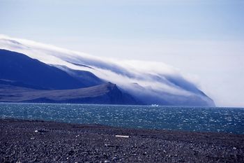 Coastal landscape of Wrangel Island in August 2012 | |
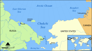 Location of Wrangel Island | |
| خطأ: الوظيفة "auto" غير موجودة. خطأ: الوظيفة "autocaption" غير موجودة. | |
| الجغرافيا | |
| الموقع | Arctic Ocean |
| الإحداثيات | 71°14′N 179°25′W / 71.233°N 179.417°W |
| المساحة | 7،600 km2 (2،900 sq mi) |
| أعلى منسوب | 1٬096 m (3٬596 ft) |
| أعلى نقطة | Soviet Mountain |
| الإدارة | |
| Federal District | Far Eastern |
| Autonomous Okrug | Chukotka |
| الاسم الرسمي | Natural System of Wrangel Island Reserve |
| النوع | Natural |
| المعيار | ix, x |
| التوصيف | 2004 (28th session) |
| الرقم المرجعي | 1023rev |
| State Party | Russian Federation |
| Region | Asia |
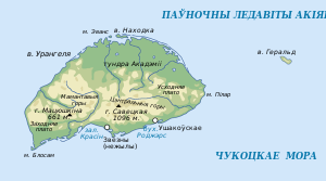
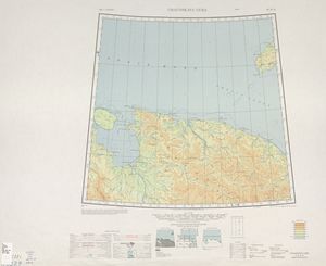
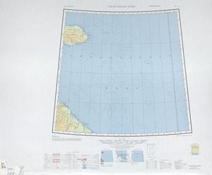
جزيرة رانجل باللغة الروسية (о́стров Вра́нгеля) جزيرة تقع في المحيط القطبي بين بحر تشوكشي وبحر سيبيريا الشرقي. وتقع الجزيرة على خط الطول 180°. لكن خط التوقيت الدولي يُزاح باتجاه الشرق حتى يطابق التوقيت على الجزيرة التوقيت على شبه جزيرة تشوكشي في البر الرئيسي. أقرب نقطة للجزيرة هي جزيرة هيرالد الصخرية الصغيرة والتي تقع على بعد 60 كلم باتجاه الشرق.[1] المسافة إلى أقرب نقطة في البر الروسي للجزيرة تقع على بعد 140 كلم.[2] وكانت جزيرة رانجل آخر مكان تعيش عليه حيوانات الماموث على الأرض.
كل جزيرة رانجل وجزيرة هيرالد محمية طبيعية إتحادية تُدار من قبل "وزارة البيئة والمحميات الطبيعية" الروسية بإعتبارها "محمية طبيعية دقيقة" منذ عام 1976. في العام 1999 مدت حكومة ((المحلية المنطقة المحمية حول جزيرة رانجل لتبلغ 24 ميلاً بحرياً. تبلغ مساحة الجزيرة 7600 كلم² ويبلغ عرضها 125 كلم.
الحياة النباتية والحيوانية
جزيرة رانجل أرض خصبة الدببة القطبية (حيث توجد أعلى كثافة للدببة القطبية في العالم على الجزيرة), الفقمة, لاموس والثعلب قطبي. وخلال موسم الصيف تصبح الجزيرة مقصداً ل 100 صنف من أنواع الطيور المهاجرة. كما تعيش قرب شواطئها أنواع من الحيتان مثل الحوت مقوس الرأس، الحوت الرمادي , الحوت الأبيض. واستمرت حيوانات الماموث بالحياة على جزيرة رانجل حتى 2000 إلى 2500 سنة قبل الميلاد، بعد إنقراضها من باقي أنحاء العالم قبل 6000 سنة قبل الميلاد.حيث بقى مابين 500 إلى 1000 ماموث تعيش على سطح الجزيرة في تلك الفترة.[2][3] أعيد توطين غزلان الرنة على الجزيرة خلال عقد الخمسينات وأزداد عددهم وأزداد عددهم حتى بلغ 1000 رنة. كما تم إعادة توطين ثور المسك في عام 1975. وقد أزداد عددها من 20 ثور إلى 200. عام 2002 رُصدت ذئاب القطب الشمالي على الجزيرة، والجزيرة كانت موطناً تأريخياً لذئاب القطب الشمالي لكنها انقرضت من الجزيرة تبعاً لإنقراض الرنة وثور المسك.
جرى إحصاء 417 صنفا من النبات العرقي على الجزيرة أي ضعف ما تمّ إحصاؤه في سائر مواقع السهل الأجرد الشمالي المماثل من حيث الحجم وأكثر من أي جزيرة أخرى في المحيط الشمالي. وبعض الأصناف مشتق من أشكال قارية متداولة في حين أنّ أخرى هي وليدة التهجين و32 منها متوطنة. ولهذه الأسباب أدرجت اليونسكو جزيرة رانجل الجبليّة (7608 كلم مربع) وجزيرة هيرالد (11 كم مربع) ومنطقة بحريّة محيطة بهما على لائحة التراث العالمي.
الجغرافيا
جيولوجيا
النباتات والحيوانات
المناخ
| بيانات المناخ لـ Wrangel Island | |||||||||||||
|---|---|---|---|---|---|---|---|---|---|---|---|---|---|
| الشهر | ينا | فب | مار | أبر | ماي | يون | يول | أغس | سبت | أكت | نوف | ديس | السنة |
| القصوى القياسية °س (°ف) | 15.1 (59.2) |
−0.2 (31.6) |
0.2 (32.4) |
2.5 (36.5) |
9.6 (49.3) |
15.9 (60.6) |
18.2 (64.8) |
16.7 (62.1) |
12.7 (54.9) |
9.3 (48.7) |
1.8 (35.2) |
2.0 (35.6) |
18.2 (64.8) |
| متوسط القصوى اليومية °س (°ف) | −19.4 (−2.9) |
−19.9 (−3.8) |
−18.6 (−1.5) |
−12.8 (9.0) |
−2.9 (26.8) |
3.4 (38.1) |
5.9 (42.6) |
5.2 (41.4) |
1.8 (35.2) |
−4.1 (24.6) |
−10.4 (13.3) |
−16.8 (1.8) |
−7.4 (18.7) |
| المتوسط اليومي °س (°ف) | −22.8 (−9.0) |
−23.5 (−10.3) |
−22.4 (−8.3) |
−16.6 (2.1) |
−5.7 (21.7) |
0.9 (33.6) |
3.0 (37.4) |
2.8 (37.0) |
0.0 (32.0) |
−6.1 (21.0) |
−12.9 (8.8) |
−19.7 (−3.5) |
−10.3 (13.5) |
| متوسط الدنيا اليومية °س (°ف) | −26.4 (−15.5) |
−27.0 (−16.6) |
−26.1 (−15.0) |
−20.4 (−4.7) |
−8.2 (17.2) |
−1.0 (30.2) |
1.0 (33.8) |
0.9 (33.6) |
−1.7 (28.9) |
−8.4 (16.9) |
−15.7 (3.7) |
−22.8 (−9.0) |
−13.0 (8.6) |
| الصغرى القياسية °س (°ف) | −42.0 (−43.6) |
−44.6 (−48.3) |
−45.0 (−49.0) |
−38.2 (−36.8) |
−31.5 (−24.7) |
−12.3 (9.9) |
−4.9 (23.2) |
−6.5 (20.3) |
−21.4 (−6.5) |
−29.8 (−21.6) |
−34.9 (−30.8) |
−57.7 (−71.9) |
−57.7 (−71.9) |
| متوسط تساقط الأمطار mm (inches) | 7 (0.3) |
7 (0.3) |
5 (0.2) |
7 (0.3) |
8 (0.3) |
10 (0.4) |
21 (0.8) |
25 (1.0) |
17 (0.7) |
13 (0.5) |
10 (0.4) |
8 (0.3) |
138 (5.4) |
| Average rainy days | 0.1 | 0.2 | 0.03 | 0.3 | 4 | 9 | 14 | 17 | 11 | 2 | 1 | 0.2 | 59 |
| متوسط الرطوبة النسبية (%) | 79 | 80 | 80 | 81 | 85 | 87 | 88 | 89 | 86 | 81 | 79 | 79 | 83 |
| Mean monthly ساعات سطوع الشمس | 2 | 59 | 195 | 267 | 199 | 233 | 226 | 125 | 73 | 50 | 4 | 0 | 1٬433 |
| Source 1: Климат о. Врангеля[4][5] | |||||||||||||
| Source 2: NOAA (sun 1961–1990)[6] | |||||||||||||
التاريخ
المستوطنات البشرية الأولى وانقراض الماموث الصوفي
اكتشاف خارجي
البعثات البريطانية والأمريكية والروسية
رحلات ستيفنسون
الإدارة السوفيتية
إنشاء المحمية الطبيعية الفيدرالية
حقبة ما بعد الاتحاد السوفيتي
القاعدة البحرية الروسية
In literature
انظر ايضا
- Russian Arctic islands
- List of islands of Russia
- List of nature reserves in Russia
- World Heritage Sites in Russia
المصادر
- ^ Kos,ko, M.K., M.P. Cecile, J.C. Harrison, V.G. Ganelin, N.V., Khandoshko, and B.G. Lopatin, 1993, Geology of Wrangel Island, Between Chukchi and East Siberian Seas, Northeastern Russia. Bulletin 461, Geological Survey of Canada, Ottawa Ontario, 101 pp.
- ^ أ ب "Radiocarbon Dating Evidence for Mammoths on Wrangel Island, Arctic Ocean, until 2000 BC".
{{cite journal}}: Cite journal requires|journal=(help) - ^ "Mammoths' extinction not due to inbreeding, study finds".
- ^ Климат о. Врангеля (in Russian). Weather and Climate (Погода и климат). Retrieved فبراير 28, 2016.
{{cite web}}: CS1 maint: unrecognized language (link) - ^ January: http://www.pogodaiklimat.ru/monitor.php?id=21982&month=1
- ^ "Vrangelja Island (Wrangel Island) Climate Normals 1961–1990". National Oceanic and Atmospheric Administration. Retrieved فبراير 28, 2016.
خطأ استشهاد: الوسم <ref> ذو الاسم "dating98" المُعرّف في <references> غير مستخدم في النص السابق.
خطأ استشهاد: الوسم <ref> ذو الاسم "distrib05" المُعرّف في <references> غير مستخدم في النص السابق.
خطأ استشهاد: الوسم <ref> ذو الاسم "aranth88" المُعرّف في <references> غير مستخدم في النص السابق.
خطأ استشهاد: الوسم <ref> ذو الاسم "nor1881" المُعرّف في <references> غير مستخدم في النص السابق.
خطأ استشهاد: الوسم <ref> ذو الاسم "rink1905" المُعرّف في <references> غير مستخدم في النص السابق.
<ref> ذو الاسم "tammik99" المُعرّف في <references> غير مستخدم في النص السابق.Works cited
- Anonymous (1923). "Wrangel Island". The Geographical Journal. 62 (6): 440–444. doi:10.2307/1781170. JSTOR 1781170.
External links
- Anonymous, 2008, Wrangel Island. at the Wayback Machine (archived ديسمبر 23, 2010) Oceandots.com (aerial image and description of Wrangel Island)
- Pictures from Wrangel Island., 2007.
- Bureau of European and Eurasian Affairs, 2003, Status of Wrangel and Other Arctic Islands. U.S. Department of State, Washington, D.C. (Fact sheet on Wrangel Island.)
- Eglin, Libby, 2000, Run For Wrangel. Tourist's account and photography.
- Eime, Roderick, nd, Wrangel Island: Isolation, Desolation and Tragedy. Comments about history and tourism of Wrangel Island.
- Gray, D., 2003, The story of the Canadian Arctic Expedition of 1913–1918. Virtual Museum of Canada, Canadian Museum of Civilization, Gatineau, Quebec. (Includes Loss of the Karluk and Wrangel Island)
- Gualtieri, L., nd, The Late Pleistocene Glacial and Sea Level History of Wrangel Island, Northeast Siberia. Quaternary Research Center, University of Washington. (Numerous comments, picture, papers, links, concerning various aspects of Wrangel Island)
- Detailed map of Wrangel Island (click link in list)
- McClanahan, A.J., nd, The Heroine of Wrangel Island. LitSite, Alaska. (Article about Ada Blackjack Johnson and Wrangel Island.)
- MacPhee, Ross, nd, Siberian Expedition to Wrangel Island., American Museum of Natural History, New York, New York. (Hunting mammoths on Wrangel Island)
- Muir, John, 1917, The Cruise of the Corwin: Journal of the Arctic Expedition of 1881 in search of De Long and the Jeannette. Norman S. Berg, Dunwoody, Georgia. John Muir's description of the 1881 exploration of Wrangel Island.
- Natural Heritage Protection Fund, 2008, Wrangel Island. Moscow, Russian Federation. (Web page about the Wrangel Island World Heritage Site.)
- Rosse, I.C., 1883, The First Landing on Wrangel Island: With Some Remarks on the Northern Inhabitants. Journal of the American Geographical Society of New York. vol. 15, pp. 163–214. Text files from Project Gutenberg. (Also, available from JSTOR at https://www.jstor.org/pss/196541)
- Stefansson, Vilhjalmur, 1921, The friendly Arctic; the story of five years in polar regions G. P. Putnam's Sons, New York, New York, 319 pp.
- UNESCO World Heritage Committee, nd, Natural System of Wrangel Island Reserve. United Nations Educational, Scientific and Cultural Organization, New York, New York.
- Russian Refuge published May 2013 National Geographic magazine


