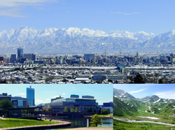
محافظة توياما
Toyama Prefecture
富山県 | |||||||||||||||
|---|---|---|---|---|---|---|---|---|---|---|---|---|---|---|---|
| الترجمة اللفظية بالـ Japanese | |||||||||||||||
| • Japanese | 富山県 | ||||||||||||||
| • Rōmaji | Toyama-ken | ||||||||||||||
 | |||||||||||||||
| النشيد: Toyama kenmin no uta | |||||||||||||||
 | |||||||||||||||
| الإحداثيات: 36°43′N 137°9′E / 36.717°N 137.150°E | |||||||||||||||
| Country | Japan | ||||||||||||||
| Region | Chūbu (Hokuriku) | ||||||||||||||
| Island | Honshu | ||||||||||||||
| Capital | Toyama | ||||||||||||||
| Subdivisions | Districts: 2، Municipalities: 15 | ||||||||||||||
| الحكومة | |||||||||||||||
| • Governor | Hachiro Nitta | ||||||||||||||
| المساحة | |||||||||||||||
| • الإجمالي | 4٬247٫61 كم² (1٬640٫01 ميل²) | ||||||||||||||
| ترتيب المساحة | 33rd | ||||||||||||||
| التعداد (June 1, 2019) | |||||||||||||||
| • الإجمالي | 1٬044٬588 | ||||||||||||||
| • الترتيب | 37th | ||||||||||||||
| • الكثافة | 250/km2 (640/sq mi) | ||||||||||||||
| ISO 3166 code | JP-16 | ||||||||||||||
| الموقع الإلكتروني | pref.toyama.jp | ||||||||||||||
| |||||||||||||||
محافظة توياما (富山県, توياما-كن) هي محافظة يابانية تقع شرقي البلاد وعاصمتها مدينة توياما. located in the Chūbu region of Honshu.[2] Toyama Prefecture has a population of 1,044,588 (1 June 2019) and has a geographic area of 4,247.61 km2 (1,640.01 sq mi). Toyama Prefecture borders Ishikawa Prefecture to the west, Gifu Prefecture to the south, Nagano Prefecture to the east, and Niigata Prefecture to the northeast.
Toyama is the capital and largest city of Toyama Prefecture, with other major cities including Takaoka, Imizu, and Nanto.[3] Toyama Prefecture is part of the historic Hokuriku region, and the majority of prefecture's population lives on Toyama Bay, one of the largest bays in Japan. Toyama Prefecture is the leading industrial prefecture on the Japan Sea coast and has the advantage of cheap electricity from abundant hydroelectric resources. Toyama Prefecture contains the only known glaciers in East Asia outside of Russia, first recognized in 2012, and 30% of the prefecture's area is designated as national parks.[4]
التاريخ
Historically, Toyama Prefecture was Etchū Province.[5] Following the abolition of the han system in 1871, Etchū Province was renamed Niikawa Prefecture, but Imizu District was given to Nanao Prefecture. In 1872 Imizu District was returned by the new Ishikawa Prefecture.
In 1876, Niikawa Prefecture was merged into Ishikawa Prefecture but the merger was void in 1881 and the area was re-established as Toyama Prefecture.[بحاجة لمصدر]
The Itai-itai disease occurred in Toyama around 1950.
المدن
توجد عشر مدن في محافظة توياما:
البلدات والقرى
Towns and villages in each district:
Niikawa Region
- Niikawa (2013)
Takaoka Region
- Takaoka (2013)
Tonami Region
- Tonami (2013)
Toyama Region
- Toyama (capital) (2013)
الاندماجات
 مقالة مفصلة: List of mergers in Toyama Prefecture
الاقتصاد
الزراعة
Toyama is a major producer of high quality rice making use of abundant water sources originating from Mount Tate.
الطاقة
The Kurobe Dam generates electricity for the Kansai Electric Power Company. It is located on the Kurobe River in Toyama Prefecture.
الديمغرافيا
Population: 1,104,239 (estimated as of Feb. 1, 2008)
علاقات دولية
 الصين، مقاطعة لياوننگ - 9 مايو 1984
 البرازيل ، ولاية ساو پاولو - 18 يوليو 1985
 الولايات المتحدة، ولاية أوريگون - October 19, 1991
 روسيا، كراي پريمورسكي - 26 أغسطس 1992
 سويسرا، مدينة بازل - 26 أكتوبر 2009[6]
 الهند، ولاية أندرا پرادش - 29 ديسمبر 2015[7]
Culture
UNESCO World Heritage Cultural Sites
Gokayama Historical Village (Nanto City)
National Treasures of Japan
Zuiryū-ji Temple (Takaoka City)
- ^ أ ب ت ث 富山県の魅力・観光>シンボル. Toyama Prefectural website (in اليابانية). Toyama Prefecture. Retrieved 9 September 2011.
- ^ Nussbaum, Louis-Frédéric. (2005). "Toyama prefecture" in Japan Encyclopedia, p. 991, p. 991, في كتب گوگل; "Hokuriku" at p. 344, p. 344, في كتب گوگل.
- ^ Nussbaum, "Toyama" at p. 991, p. 991, في كتب گوگل.
- ^ Matsutani, Minoru (April 6, 2012). "First glaciers in Japan recognised". The Japan Times. Retrieved May 20, 2012.
- ^ Nussbaum, "Provinces and prefectures" at p. 780, p. 780, في كتب گوگل.
- ^ "Toyama Prefecture". Canton Basel-Stadt. Retrieved December 9, 2022.
- ^ "Andhra Pradesh inks pact with Toyama Prefecture". The Hindu. December 29, 2015. Retrieved February 17, 2019.
- Pages using gadget WikiMiniAtlas
- Short description matches Wikidata
- Short description is different from Wikidata
- Coordinates on Wikidata
- Articles with hatnote templates targeting a nonexistent page
- Articles with unsourced statements from December 2013
- Toyama Prefecture
- Chūbu region
- Prefectures of Japan
- Hokuriku region
- محافظات اليابان
- CS1 uses اليابانية-language script (ja)
- CS1 اليابانية-language sources (ja)


