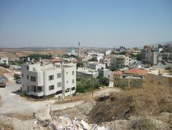
الناعورة
الناعورة | |
|---|---|
 | |
| الإحداثيات: 32°36′52″N 35°23′28″E / 32.61444°N 35.39111°E | |
| Grid position | 187/224 PAL |
| البلد | |
| District | Northern |
| المجلس | جلبوع |
| التعداد (2019)[1] | 2٬324 |
الناعورة (بالعبرية: נָעוּרָה ؛ Na'ura)، هي قرية فلسطينية في شمال إسرائيل. وتقع إلى الشرق من مدينة العفولة، ضمن مجلس جلبوع المحلي. وفي 2019، بلغ عدد سكانها 2,324 نسمة.[1] وكل سكان هذه القرية من عائلة واحدة وهي الزعبي.
تقع إلى الجنوب الشرقي من مدينة الناصرة. وتبعد عنها 16 كم وترتفع 100 م عن سطح البحر. وتقوم في مكان قرية (أناحرة) الكنعانية بمعنى مضيق أو ممر. وتبلغ مساحة أراضيها حوالي (11036) دونماً. تحيط بها أراضي قرى تمرة وعين دور والدحى وقومية. وقُدر عدد سكانها عام 1922 حوالي (200) نسمة. وفي عام 1945 حوالي (240) نسمة، وفي عام 1948 حوالي (348) نسمة. تحتوي القرية على آثار محلة تحت الأرض وعلى شقف فخار وأساسات وناموس مكسور ومقبرة.
انظر أيضاً
الهامش
- ^ أ ب "Population in the Localities 2019" (XLS). Israel Central Bureau of Statistics. Retrieved 16 August 2020.
ببليوگرافيا
- Barron, J. B., ed. (1923). Palestine: Report and General Abstracts of the Census of 1922. Government of Palestine.
- Conder, C.R.; Kitchener, H. H. (1882). The Survey of Western Palestine: Memoirs of the Topography, Orography, Hydrography, and Archaeology. Vol. 2. London: Committee of the Palestine Exploration Fund. (p. 85)
- Covello-Paran, Karen (2014-12-08). "Na'ura, Final Report" (126). Hadashot Arkheologiyot – Excavations and Surveys in Israel.
{{cite journal}}: Cite journal requires|journal=(help) - Dalali-Amos, Edna (2007-09-11). "Na'ura, Final Report" (119). Hadashot Arkheologiyot – Excavations and Surveys in Israel.
{{cite journal}}: Cite journal requires|journal=(help) - Dalali-Amos, Edna (2011-11-28). "Na'ura, Final Report" (123). Hadashot Arkheologiyot – Excavations and Surveys in Israel.
{{cite journal}}: Cite journal requires|journal=(help) - Dalali-Amos, Edna (2018-03-29). "Na'ura, Final Report" (130). Hadashot Arkheologiyot – Excavations and Surveys in Israel.
{{cite journal}}: Cite journal requires|journal=(help) - Dauphin, Claudine (1998). La Palestine byzantine, Peuplement et Populations. BAR International Series 726 (in French). Vol. III : Catalogue. Oxford: Archeopress. ISBN 0-860549-05-4.
{{cite book}}: CS1 maint: unrecognized language (link) (p. 736) - Department of Statistics (1945). Village Statistics, April, 1945. Government of Palestine.
- Guérin, V. (1880). Description Géographique Historique et Archéologique de la Palestine (in French). Vol. 3: Galilee, pt. 1. Paris: L'Imprimerie Nationale.
{{cite book}}: CS1 maint: unrecognized language (link) (p. 124) - Hadawi, S. (1970). Village Statistics of 1945: A Classification of Land and Area ownership in Palestine. Palestine Liberation Organization Research Center.
- Hartal, Moshe (2010-09-07). "Na'ura, Final Report" (122). Hadashot Arkheologiyot – Excavations and Surveys in Israel.
{{cite journal}}: Cite journal requires|journal=(help) - Hütteroth, Wolf-Dieter; Abdulfattah, Kamal (1977). Historical Geography of Palestine, Transjordan and Southern Syria in the Late 16th Century. Erlanger Geographische Arbeiten, Sonderband 5. Erlangen, Germany: Vorstand der Fränkischen Geographischen Gesellschaft. ISBN 3-920405-41-2. (p. 157)
- Karmon, Y. (1960). "An Analysis of Jacotin's Map of Palestine" (PDF). Israel Exploration Journal. 10 (3, 4): 155–173, 244–253. (p. 169)
- Mills, E., ed. (1932). Census of Palestine 1931. Population of Villages, Towns and Administrative Areas. Jerusalem: Government of Palestine.
- Mokary, Abdalla (2016-03-30). "Na'ura, Final Report" (128). Hadashot Arkheologiyot – Excavations and Surveys in Israel.
{{cite journal}}: Cite journal requires|journal=(help) - Palmer, E. H. (1881). The Survey of Western Palestine: Arabic and English Name Lists Collected During the Survey by Lieutenants Conder and Kitchener, R. E. Transliterated and Explained by E.H. Palmer. Committee of the Palestine Exploration Fund. (p. 166)
- Robinson, E.; Smith, E. (1856). Later Biblical Researches in Palestine and adjacent regions: A Journal of Travels in the year 1852. London: John Murray. (Robinson and Smith, 1856, p. 338)
وصلات خارجية
- Welcome To Na'ura
- Survey of Western Palestine, Map 9: IAA, Wikimedia commons

