القطب المغناطيسي الشمالي

القطب المغناطيسي الشمالي North Magnetic Pole هي نقطة على سطح نصف الكرة الشمالي من الأرض يكون عندها المجال المغناطيسي للكوكب متجهاً رأسياً لأسفل (بعبارةٍ أخرى، لو إبرة بوصلة مغناطيسية سُمح لها بالدوران حول محور أفقي، فسوف تشير للأسفل مباشرة). ويوجد موقع واحد فقط حيث يحدث ذلك، بالقرب من (ولكن مختلف عن) القطب الجغرافي الشمالي والقطب الجيومغناطيسي الشمالي.
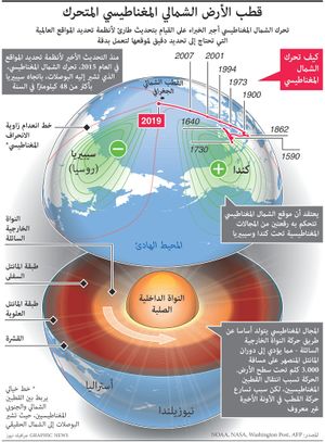
يتحرك القطب المغناطيسي الشمالي على مدار الوقت بسبب التغيرات المغناطيسية في لب الأرض.[2] في 2001، تم تحديده عن طريق المسح الجيولوجي الكندي ليكون بالقرب من جزيرة إلسمر في شمال كندا على إحداثيات 81°18′N 110°48′W / 81.3°N 110.8°W. في 2005، وُضع على إحداثيات 83°06′N 117°48′W / 83.1°N 117.8°W. في 2009، بينما كان لا يزال ضمن المطالبة الإقليمية بالقطب الشمالي الكندي على إحداثيات 84°54′N 131°00′W / 84.9°N 131.0°W،[3] كانت ينتقل تجاه روسيا بين 34 and 37 miles (55 and 60 km) سنوياً.[4] في 2012، كان من المتوقع أن ينتقل القطب إلى ما وراء المطالبة الإقليمية بالقطب الشمالي الكندي إلى 85°54′N 147°00′W / 85.9°N 147.0°W.[3]
القطب المغناطيسي الجنوبي هو نظيره في نصف الكرة الجنوبي. حيث أن المجال المغناطيسي للأرض غير متنظار تماماً، فالقطب المغناطيسي الشمالي والجنوبي غير متناظرين: على سبيل المثال، الخط المرسوم من أحد القطبين للآخر لا يسلك نفس المركز الهندسي على الأرض.
القطب المغناطيسي الشمالي والجنوبي للأرض يعرفان أيضاً بالأقطاب المغناطيسية المتراجعة مع الإشارة إلى "التراجع" العمودي لخطوط المجال المغناطيسي عن تلك النقاط.[5]
Its southern hemisphere counterpart is the south magnetic pole. Since Earth's magnetic field is not exactly symmetric, the north and south magnetic poles are not antipodal, meaning that a straight line drawn from one to the other does not pass through the geometric center of Earth.
Earth's north and south magnetic poles are also known as magnetic dip poles, with reference to the vertical "dip" of the magnetic field lines at those points.[6]
| Year | 1990 (definitive) | 2000 (definitive) | 2010 (definitive) | 2020 |
|---|---|---|---|---|
| North magnetic pole | 78°05′42″N 103°41′20″W / 78.095°N 103.689°W | 80°58′19″N 109°38′24″W / 80.972°N 109.640°W | 85°01′12″N 132°50′02″W / 85.020°N 132.834°W | 86°29′38″N 162°52′01″E / 86.494°N 162.867°E |
| South magnetic pole | 64°54′36″S 138°54′07″E / 64.910°S 138.902°E | 64°39′40″S 138°18′11″E / 64.661°S 138.303°E | 64°25′55″S 137°19′30″E / 64.432°S 137.325°E | 64°04′52″S 135°51′58″E / 64.081°S 135.866°E |
. . . . . . . . . . . . . . . . . . . . . . . . . . . . . . . . . . . . . . . . . . . . . . . . . . . . . . . . . . . . . . . . . . . . . . . . . . . . . . . . . . . . . . . . . . . . . . . . . . . . . . . . . . . . . . . . . . . . . . . . . . . . . . . . . . . . . . . . . . . . . . . . . . . . . . . . . . . . . . . . . . . . . . . .
القطبية
All magnets have two poles, where lines of magnetic flux enter one pole and emerge from the other pole. By analogy with Earth's magnetic field, these are called the magnet's "north" and "south" poles. The north-seeking pole of a magnet was defined to have the north designation, according to their use in early compasses. Because opposite poles attract, this means that as a physical magnet, the magnetic north pole of the earth is actually on the southern hemisphere.[8][9]
The direction of magnetic field lines is defined such that the lines emerge from the magnet's north pole and enter into the magnet's south pole.
التاريخ

Early European navigators, cartographers and scientists believed that compass needles were attracted to a hypothetical "magnetic island" somewhere in the far north (see Rupes Nigra), or to Polaris, the pole star.[10] The idea that Earth itself acts as essentially a giant magnet was first proposed in 1600, by the English physician and natural philosopher William Gilbert. He was also the first to define the north magnetic pole as the point where Earth's magnetic field points vertically downwards. This is the current definition, though it would be a few hundred years before the nature of Earth's magnetic field was understood with modern accuracy and precision.[10]
الحملات والقياسات
الأرصاد الأولى
The first group to reach the north magnetic pole was led by James Clark Ross, who found it at Cape Adelaide on the Boothia Peninsula on June 1, 1831, while serving on the second arctic expedition of his uncle, Sir John Ross. Roald Amundsen found the north magnetic pole in a slightly different location in 1903. The third observation was by Canadian government scientists Paul Serson and Jack Clark, of the Dominion Astrophysical Observatory, who found the pole at Allen Lake on Prince of Wales Island in 1947.[11]
مشروع پولاريس
At the start of the Cold War, the United States Department of War recognized a need for a comprehensive survey of the North American Arctic and asked the United States Army to undertake the task. An assignment was made in 1946 for the Army Air Forces' recently formed Strategic Air Command to explore the entire Arctic Ocean area. The exploration was conducted by the 46th (later re-designated the 72nd) Photo Reconnaissance Squadron and reported on as a classified Top Secret mission named Project Nanook. This project in turn was divided into many separate, but identically classified, projects, one of which was Project Polaris, which was a radar, photographic (trimetrogon, or three-angle, cameras) and visual study of the entire Canadian Archipelago. A Canadian officer observer was assigned to accompany each flight.
Frank O. Klein, the director of the project, noticed that the fluxgate compass did not behave as erratically as expected—it oscillated no more than 1 to 2 degrees over much of the region—and began to study northern terrestrial magnetism.[12][13] With the cooperation of many of his squadron teammates in obtaining many hundreds of statistical readings, startling results were revealed: The center of the north magnetic dip pole was on Prince of Wales Island some 400 km (250 mi) NNW of the positions determined by Amundsen and Ross, and the dip pole was not a point but occupied an elliptical region with foci about 400 km (250 mi) apart on Boothia Peninsula and Bathurst Island. Klein called the two foci local poles, for their importance to navigation in emergencies when using a "homing" procedure.[مطلوب توضيح] About three months after Klein's findings were officially reported, a Canadian ground expedition was sent into the Archipelago to locate the position of the magnetic pole. R. Glenn Madill, Chief of Terrestrial Magnetism, Department of Mines and Resources, Canada, wrote to Lt. Klein on 21 July 1948:
… we agree on one point and that is the presence of what we can call the main magnetic pole on northwestern Prince of Wales Island. I have accepted as a purely preliminary value the position latitude 73°N and longitude 100°W. Your value of 73°15'N and 99°45’W is in excellent agreement, and I suggest that you use your value by all means.
— R. Glenn Madill[12]
(The positions were less than 30 km (20 mi) apart.)
حديثة: 1996-الحاضر
The Canadian government has made several measurements since, which show that the north magnetic pole is moving continually northwestward. In 2001, an expedition located the pole at 81°18′N 110°48′W / 81.300°N 110.800°W.
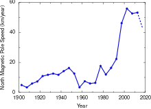
In 2007, the latest survey found the pole at 83°57′00″N 120°43′12″W / 83.95000°N 120.72000°W.[14] During the 20th century it moved 1,100 km (680 mi), and since 1970 its rate of motion has accelerated from 9 to 52 km (5.6 to 32.3 mi) per year (2001–2007 average; see also polar drift). Members of the 2007 expedition to locate the magnetic north pole wrote that such expeditions have become logistically difficult, as the pole moves farther away from inhabited locations. They expect that in the future, the magnetic pole position will be obtained from satellite data instead of ground surveys.[14]
This general movement is in addition to a daily or diurnal variation in which the north magnetic pole describes a rough ellipse, with a maximum deviation of 80 km (50 mi) from its mean position.[15] This effect is due to disturbances of the geomagnetic field by charged particles from the Sun.
في 5 فبراير 2019 وصلت سرعة القطب الشمالي المغناطيسي تجاه سيبيريا إلى ما يقارب 55 كم/س مما أثار مخاوف حول تأثيره على أنظمة الجي بي إس العالمية.[16]
The NOAA gives the 2024 location of the magnetic north pole as 86 degrees North, 142 degrees East. By 2025, it will have drifted to 138 degrees East (same latitude). [17]
كان القطب المغناطيسي الشمالي يتحرك ببطء عبر القطب الشمالي الكندي في اتجاه روسيا منذ عام 1831. لكن انحرافه السريع نحو سيبيريا في السنوات الأخيرة بسرعة 60 كم/س تقريباً. دفع هذا العلماء إلى تحديث النموذج المغناطيسي العالمي الذي يجدد كل خمس سنوت إلى تحديثه قبل الموعد المحدد. يستخدم هذا النظام من قبل أنظمة الملاحة المدنية، والناتو، والجيش الأمريكي والبريطاني.[18]
النموذج المعتمد من قبل الوكالات العسكرية الأمريكية والبريطانية، تم تحديثه في 2015، لكن الإدارة الوطنية للمحيطات والغلاف الجوي أوضحت في 5 فبراير 2019، أن هذا التحديث الغير دوري، يهدف إلى ضمان الملاحة الآمنة للأغراض المدنية والعسكرية، وكذلك لشركات الطيران التجارية وعمليات البحث والإنقاذ وغيرها التي تعمل حول القطب الشمالي.
Magnetic north and magnetic declination
Historically, the magnetic compass was an important tool for navigation. While it has been widely replaced by Global Positioning Systems, many airplanes and ships still carry them, as do casual boaters and hikers.[19]
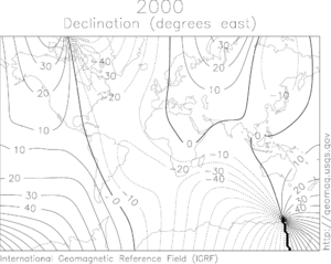
The direction in which a compass needle points is known as magnetic north. In general, this is not exactly the direction of the north magnetic pole (or of any other consistent location). Instead, the compass aligns itself to the local geomagnetic field, which varies in a complex manner over Earth's surface, as well as over time. The local angular difference between magnetic north and true north is called the magnetic declination. Most map coordinate systems are based on true north, and magnetic declination is often shown on map legends so that the direction of true north can be determined from north as indicated by a compass.[20]
In North America the line of zero declination (the agonic line) runs from the north magnetic pole down through Lake Superior and southward into the Gulf of Mexico (see figure). Along this line, true north is the same as magnetic north. West of the agonic line a compass will give a reading that is east of true north and by convention the magnetic declination is positive. Conversely, east of the agonic line a compass will point west of true north and the declination is negative.[21]
. . . . . . . . . . . . . . . . . . . . . . . . . . . . . . . . . . . . . . . . . . . . . . . . . . . . . . . . . . . . . . . . . . . . . . . . . . . . . . . . . . . . . . . . . . . . . . . . . . . . . . . . . . . . . . . . . . . . . . . . . . . . . . . . . . . . . . . . . . . . . . . . . . . . . . . . . . . . . . . . . . . . . . . .
القطب الجيومغناطيسي الشمالي
 مقالة مفصلة: قطب جيومغناطيسي
كتقريب من الترتيب الأول، يمكن للقطب المغناطيسي للأرض أن يكون على غرار ثنائي القطب البسيط (مثل القضيب المغناطيسي)، بميل 10° على محور دوران الأرض (والذي يحدد القطب الشمالي الجيومغناطيسي والجنوبي الجيومغناطيسي) ويتمركز عند مركز الأرض. القطب الشمالي الجيومغناطيسي والجنوبي الجيومغناطيسي هما نقطتين متقابلتين حيث يتقاطع ثنائي القطب النظري لهما مع سطح الأرض. إذا كان المجال المغناطيسي للأرض ثنائي القطب كامل فعندها تكون خطوط المجال عمودية على القطبين الجيومغناطيسيين، ومتزامنة مع القطبين المغناطيسيين. ومع ذلك، فالتقريب غير كامل، ولذا فإن القطب المغناطيسي والجيومغناطيسي يقعان على مسافة بعيدة من بعضهما البعض.[22]
مثل القطب المغناطيسي الشمالي، يجذب القطب الجيومغناطيسي الشمالي القطب الشمالي للقضيب المغناطيسي ومن ثم فهو بالمعنى المادي عبارة عن قطب مغناطيسي جنوبي. وهو يمثل مركز منطقة غلاف مغناطيسي التي يمكن أن يرى فيها الشفق القطبي. في 2005 كان يقع تقريباً على إحداثيات 79°44′N 71°47′W / 79.74°N 71.78°W، قبالة الساحل الشمالي الغربي لگرينلاند،[22] لكنه ينجرف الآن بعيداً عن أمريكا الشمالية تجاه سيبريا.
الانعكاس الجيومغناطيسي
على مدى عمر الأرض، انعكس اتجاه المجال المغناطيسي للأرض عدة مرات، ليصبح الشمال المغناطيسي جنوب مغناطيسي والعكس، في حدث يعرف بالانعكاس الجيومغناطيسي. يمكن رؤية دليل الانعكاسات الجيومغناطيسية في حيود وسط المحيط حيث تتحرك الصفائح التكتونية بعيداً ويكون قاع المحيط مليء بالصهارة. بتسرب الصهارة من الوشاح، تتوجه الجزئيات المغناطيسية الواردة في اتجاه المجال المغناطيسي في الوقت الذي تبدأ فيه الصهارة في البرودة والتصلب.[23]
اكتشافات
القطب المغناطيسي الشمالي يتحرك باستمرار وهذا معروف علميًا. لكن أن تقفز سرعته القصوى من 14 كم/السنة إلى 60كم/السنة في ظرف 15 سنة (1990-2005م) فهذا ليس عاديًا. يجب أن تخضع هذه المسألة إلى دراسات كثيرة لفهم الأسباب. الصورة توضَّح حركته من الأراضي الكندية إلى سيبيريا في روسيا.التدفق المستمر للحديد والنيكل وبقيّة المواد المنصهرة في باطن الأرض يولّد مجالًا مغناطيسيًا يتسبّب في حركة القطب المغناطيسي الشمالي بشكل مستمر. هل من الممكن أن تنقلب الأقطاب المغناطيسية للأرض؟ نظريًا نعم. متى؟ لا توجد نماذج تقديرية دقيقة لوجود عدّة عوامل قد تُؤثر على ذلك الانقلاب.[24] As the magma seeps out of the mantle, cools, and solidifies into igneous rock, it is imprinted with a record of the direction of the magnetic field at the time that the magma cooled.[25]
انظر أيضاً
الهوامش والمصادر
- ^ "Magnetic North, Geomagnetic and Magnetic Poles". wdc.kugi.kyoto-u.ac.jp. Retrieved 2019-12-18.
- ^ Merrill, Ronald T.; McElhinny, Michael W.; McFadden, Phillip L. (1996). "Chapter 8". The magnetic field of the earth: paleomagnetism, the core, and the deep mantle. Academic Press. ISBN 978-0-12-491246-5.
- ^ أ ب World Data Center for Geomagnetism, Kyoto. "Magnetic North, Geomagnetic and Magnetic Poles". Retrieved 2012-07-03.
- ^ North Magnetic Pole Moving East Due to Core Flux, National Geographic, December 24, 2009
- ^ "The Magnetic North Pole". Ocean bottom magnetology laboratory. Woods Hole Oceanographic Institution. Retrieved June 2012.
{{cite web}}: Check date values in:|accessdate=(help) - ^ "The Magnetic North Pole". Ocean bottom magnetology laboratory. Woods Hole Oceanographic Institution. Archived from the original on 2013-08-19. Retrieved 2017-02-06.
- ^ خطأ استشهاد: وسم
<ref>غير صحيح؛ لا نص تم توفيره للمراجع المسماةNGDC_WAND - ^ Serway, Raymond A.; Chris Vuille (2006). Essentials of college physics. US: Cengage Learning. p. 493. ISBN 0-495-10619-4. Archived from the original on 2019-05-15. Retrieved 2012-04-19.
- ^ Russell, Randy. "Earth's Magnetic Poles". Windows to the Universe. National Earth Science Teachers Association. Retrieved 2012-04-19.
- ^ أ ب Early Concept of the North Magnetic Pole, Natural Resources Canada, retrieved June 2007
- ^ History of Expeditions to the North Magnetic Pole, Natural Resources Canada
- ^ أ ب White, Ken (1994). World in Peril: The Origin, Mission & Scientific Findings of the 46th / 72nd Reconnaissance Squadron (2nd revised ed.). K. W. White & Associates. ISBN 978-1883218102.
- ^ Wack, Fred John (1992). The Secret Explorers: Saga of the 46th/72nd Reconnaissance Squadrons. Seeger's Print.
- ^ أ ب L. R. Newitt, A. Chulliat, and J.-J. Orgeval, Location of the north magnetic pole in April 2007, Earth Planets Space, 61, 703–710, 2009
- ^ Geomagnetism – Daily Movement of the North Magnetic Pole, Natural Resources Canada
- ^ "Polar express: magnetic north pole moving 'pretty fast' towards Russia". Associated Press. 5 February 2019 – via theguardian.com.
- ^ "Wandering of the Geomagnetic Poles". NOAA.
- ^ "Earth's magnetic north pole is hurtling toward Russia". سي إن إن. 2019-02-05. Retrieved 2019-02-05.
- ^ "Compass". National Geographic Society (in الإنجليزية). 3 December 2013. Retrieved 25 August 2018.
- ^ "Magnetic declination". Natural Resources Canada (in الإنجليزية). Government of Canada. Retrieved 25 August 2018.
- ^ USGS Education. "How To Use a Compass with a USGS Topographic Map". United States Geological Survey. Retrieved 25 August 2018.
- ^ أ ب "Geomagnetism Frequently Asked Questions". National Geophysical Data Center. Retrieved 19 April 2012.
- ^ Earth's Inconstant Magnetic Field – NASA Science
- ^ "Recent north magnetic pole acceleration towards Siberia caused by flux lobe elongation".
- ^ "Earth's Inconstant Magnetic Field – Science Mission Directorate". science.nasa.gov. 29 December 2003.
وصلات خارجية
- "Wandering of the geomagnetic poles". Geomagnetism. National Geophysical Data Center. Retrieved 19 April 2012.
- "Geomagnetism". Natural Resources Canada. April 1, 2012. Retrieved 19 April 2012.
- Map of pole's wandering
- "North Magnetic Pole could be leaving Canada". CNN.com. 20 March 2002. Retrieved 19 April 2012.
- "Magnetic pole drifting fast". BBC News. 12 December 2005. Retrieved 19 April 2012.
- "The Earth's magnetic field". Astronomy Picture of the Day. NASA. Retrieved 2012-04-19.
- Pages using gadget WikiMiniAtlas
- Articles with hatnote templates targeting a nonexistent page
- Missing redirects
- Short description is different from Wikidata
- Coordinates on Wikidata
- جميع الصفحات التي تحتاج تنظيف
- مقالات بالمعرفة تحتاج توضيح from February 2014
- قوائم إحداثيات
- Geographic coordinate lists
- Articles with Geo
- جغرافيا الأراضي الشمالية الغربية
- المناطق القطبية على الأرض
- جغرافيا القارة القطبية الشمالية
- مغناطيسية أرضية
- Orientation (geometry)
- جيولوجيا القارة القطبية الشمالية


