العمرة، قنا
العمرة | |
|---|---|
 العمرة خريطة مصر تبين العمرة | |
| الإحداثيات: 26°8′35.22″N 31°58′6.41″E / 26.1431167°N 31.9684472°E |
قرية العمرة El-Amrah هي إحدى القرى التابعة لمركز أبو تشت في محافظة قنا في جمهورية مصر العربية. حسب إحصاءات سنة 2006، بلغ إجمالي السكان في العمرة 12,093 نسمة، منهم 5727 رجل و6366 امرأة.[1]
. . . . . . . . . . . . . . . . . . . . . . . . . . . . . . . . . . . . . . . . . . . . . . . . . . . . . . . . . . . . . . . . . . . . . . . . . . . . . . . . . . . . . . . . . . . . . . . . . . . . . . . . . . . . . . . . . . . . . . . . . . . . . . . . . . . . . . . . . . . . . . . . . . . . . . . . . . . . . . . . . . . . . . . .
الموقع الأثري
 مقالة مفصلة: الثقافة العمراتية
العمرة تضم موقعاً أثرياً يبعد 120 كم جنوب البداري، محافظة أسيوط.[2]
Archaeological discoveries in 1901 at El-Amrah, were the basis of what is now known as the الثقافة العمراتية, a Naqada I culture[3] of predynastic Upper Egypt, that lasted from 4400 BC to ح. 3500 BC.[4]
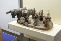
Model cattle, El-Amra, Naqada I, British Museum EA 35506
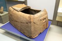
Pre-Dynastic model house, El-Amra, Naqada IIC until 3200 BCE, British Museum EA35505


طالع أيضا
المصادر
- ^ "البيانات السكانية لمدينة أو قرية حسب تقديرات السكان 2006". الجهاز المصري المركزي للإحصاء.
{{cite web}}:|archive-url=requires|archive-date=(help); Unknown parameter|access_date=ignored (help); Unknown parameter|تاريخ أرشيف=ignored (help); Unknown parameter|وصلة مكسورة=ignored (help) - ^ David Randall-MacIver; A C Mace; F Ll Griffith El Amrah and Abydos, 1899-1901, (Offices of the Egypt exploration fund 1902, London, Boston, Mass.,).
- ^ Grimal, Nicolas (1992). A History of Ancient Egypt. Blackwell. p. 28.
- ^ Shaw, Ian, ed. (2000). The Oxford History of Ancient Egypt. Oxford University Press. p. 479.
- Pages using gadget WikiMiniAtlas
- CS1 errors: unsupported parameter
- CS1 errors: archive-url
- Short description is different from Wikidata
- Coordinates on Wikidata
- Pages using infobox settlement with unknown parameters
- Pages using infobox settlement with missing country
- اكتشافات أثرية في 1901
- الألفية 4 ق م في مصر
- شعوب أصلية في شرق إفريقيا
- قرى أبو تشت
- مصر قبل الأسرات
- مواقع أثرية في محافظة قنا