جيولوجيا شبه جزيرة أيبريا
جيولوجيا شبه جزيرة أيبريا تتألف من دراسة التشكيلات الصخرية في شبه جزيرة أيبريا، التي تضم اسبانيا، البرتغال، أندورا، وجبل طارق. وضتم شبه الجزيرة صخرواً من كل عصر جيولوجي، من إدياكاران إلى الحاضر، وتقريباً كل نوع من أنواع الصخور توجد فيها. كما توجد رواسب معدنية على مستوى عالمي في شبه الجزيرة.
. . . . . . . . . . . . . . . . . . . . . . . . . . . . . . . . . . . . . . . . . . . . . . . . . . . . . . . . . . . . . . . . . . . . . . . . . . . . . . . . . . . . . . . . . . . . . . . . . . . . . . . . . . . . . . . . . . . . . . . . . . . . . . . . . . . . . . . . . . . . . . . . . . . . . . . . . . . . . . . . . . . . . . . .
الماسيف الأيبيري
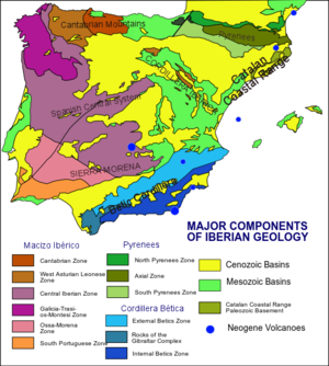
يُعدّ القسم الأوسط من شبه الجزيرة الإيبرية جزءاً من التكوينات الهرسينية القديمة التي تكونت في أوربا في أواخر العصر الفحمي ، أي قبل 325 مليون سنة تقريباً. غير أن هذه الكتلة تعرضت لمراحل طويلة من الحت والتعرية وأصبحت مسواة على شكل أشباه سهول. وقد غمرت المياه في الحقب الثاني، أي قبل 225 مليون سنة، وبصورة متكررة، أجزاء كبيرة من هذه الكتلة ووضَّعت فوقها رسوبات سميكة. ثم تعرضت هذه الرسوبات والقاعدة التي تجثم تحتها، في حقبة بناء الجبال الألبية التي بدأت في أواخر الحقب الثاني، أي قبل 70 مليون سنة، إلى ضغوط شديدة أدت إلى نهوض القاعدة وتصدعها والتواء الرسوبات فوقها، فتكونت السلاسل الحالية المحيطة بالهضبة الوسطى، وأخذت شبه الجزيرة شكلها الحالي تقريباً.
أما توضعات الحقب الثالث فقد تركزت في المنخفضات والأحواض التي في الهضبة الوسطى، وفي أحواض نهري إبرو Ebro والوادي الكبير Guadalquivir. وقد كان بعض هذه الأحواض ما يزال مغموراً بالمياه في أواخر الحقب الثاني فتوضعت فيها رسوبات سميكة تصل إلى 3000م، وتوضعت في بعضها الآخر رسوبات قارية يصل ثخنها في بعض الأماكن إلى 4000م. ولم يكن للعصر الجليدي تأثير يذكر في شبه الجزيرة إلا في السلاسل الجبلية الشمالية المرتفعة، حيث أدت الجليديات إلى تعميق مصابّ الأنهار، التي تأثرت بالحت النهري وغمر البحار فيما بعد وتكوين مايسمى بسواحل الرياس Rias (مفردها ريا) المنتشرة على سواحل إسبانية الشمالية، وانتشار الحصى و الركام الجليدي في مناطق محدودة على السفوح الدنيا للجبال.
المنطقة الكانتابرية

المنطقة الليونية الأستورية الغربية
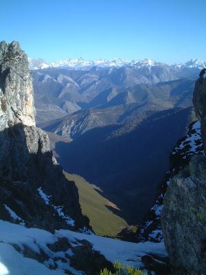
منطقة گاليسيا-تراس-اوس-مونتس
Ossa Morena Zone
منطقة جنوب البرتغال
Intrusions
Mesozoic
الحوض الأيبيري
الپرانس

Betics
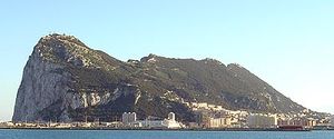
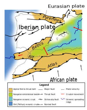
The Betic Cordillera is a mountain range in southern and southeastern Spain, oriented in a ENE direction. وتمتد من خليج قادس إلى Cabo de la Nao.
The Betics هي جزء من قوس جبل طارق، الذي يضم أيضاً الريف في المغرب.
أثناء الأزمنة الترياسية والجوراسية كانت the Betic and Maghrebian margins were opposite each other.
جزر البليار
The Balearic Islands are on a raised platform called the Balearic Promontory.
مايوركا:
- Port d’es Canonge Formation – Guadalupian
- Asa Formation – Lopingian Permian
- Son Serralta Formation Anisian Triassic
مينوركا:
- Saxonian Facies = Asa Fm Lopingian Permian 260-251 Ma
- Conglomerate – Olenekian Smithian substage 249 Ma
- Buntsandstein from Olenekian to Anisian Triassic 248-237 Ma
- Muschelkalk Ladinian 237-238 Ma
حوض الإبرو
. . . . . . . . . . . . . . . . . . . . . . . . . . . . . . . . . . . . . . . . . . . . . . . . . . . . . . . . . . . . . . . . . . . . . . . . . . . . . . . . . . . . . . . . . . . . . . . . . . . . . . . . . . . . . . . . . . . . . . . . . . . . . . . . . . . . . . . . . . . . . . . . . . . . . . . . . . . . . . . . . . . . . . . .
حوض التاخو
السلاسل الساحلية القطلانية
البراكين
المقاييس الجيوفيزيقية
The Crustal thickness is 30 to 35 km through most of Iberia, but thins to 28 km on the west coast. The force exerted by the ridge push from the Atlantic sea floor is 3.0 TN/m (1012 newtons per meter); 54 Ma the force was lower at 2 TN/m.
The Crustal depth in the Iberian Massif is 30 to 35 km. Western Betics have crust 39 km thick and in three layers. Eastern Betics have a crust of 23 km thick in two layers. Along the coast crust is 23 to 25 km. Betic lithosphere is 100 to 110 km thick. Under the Alboran Sea the crust is 16 km thick. Alboran lithosphere is 40 km thick.
The Tajo and Duero basins are elevated and yet show a negative Bouguer anomaly. This is likely due to a less dense crust. In the Ossa Moena zone and South Portuguese Zone there is a positive Bouguer anomaly, due to higher crustal density. Along the Mediterranean Coast there is a positive Bouguer anomaly due to lithosphere thinned to less than 75 km.
GPS stations measure the slow movements due to continental drift and tectonic movements:
| GAIA | Vila Nova de Gaia |
| CASC | Cascais |
| OALN | Observatório Astronómico de Lisboa Norte |
| OALS | Observatório Astronómico de Lisboa Sul |
| LAGO | لاگوس |
| SFER | سان فرناندو |
| VILL | Villa Franca del Campo |
| MADR | مدريد |
Heat flow 60–70 mW/m2 on Iberian Massif and in the Betics with 100–120 mW/m2 in the Alboran Sea where the lithosphere is thinner. A low heat flow of 40 mW/m2 is in the far south of Portugal.
الجيولوجيا الاقتصادية
التعدين
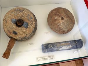
للتعدين تاريخ طويل في اسبانيا. أكبر ترسيب من الزئبق في العالم يوجد في اسبانيا.
المخاطر الأرضية
زلزال لشبونة الكبير في 1 نوفمبر 1755 كان أحد أكثر الزلازل تدميراً في التاريخ، إذ قتل نحو 100,000 نسمة.
قطاعات ونقاط الحدود العامة للطبقات
العديد من Global Boundary Stratotype Sections and Points تم تعريفهم في شبه الجزيرة الأيبيرية.
| Epoch | المرحلة | العمر (mya) | Status | GSSP location | Defining markers | الإحداثيات الجغرافية | المراجع |
|---|---|---|---|---|---|---|---|
| Eocene | Lutetian | 47.8 | Gorrondatxe sea-cliff section,
Western Pyrenees, Basque Country, Spain |
|
43°22′47″N 3°00′51″W / 43.3796°N 3.0143°W | [1] | |
| Paleocene | Thanetian | 59.2 | Zumaia Section,
Basque Country, Spain |
|
43°17′59″N 2°15′39″W / 43.2996°N 2.2609°W | [2] | |
| Paleocene | Selandian | 61.6 | Zumaia Section,
Basque Country, Spain |
|
43°17′57″N 2°15′40″W / 43.2992°N 2.2610°W | [2] | |
| Cretaceous | Santonian | 86.3 | Candidate sections:
|
|
- | [3] | |
| Cretaceous | Barremian | 129.4 | Candidate section:
|
|
- | - | |
| Cretaceous | Valanginian | 139.8 | Candidates sections:
|
|
- | - | |
| Jurassic | Bajocian | 170.3 | Cabo Mondego, Portugal |
|
40°11′57″N 8°54′15″W / 40.1992°N 8.9042°W | [4] | |
| Jurassic | Aalenian | 174.1 | Fuentelsaz, Spain |
|
41°10′15″N 1°50′00″W / 41.1708°N 1.8333°W | [5] | |
| Jurassic | Toarcian | 182.7 | Peniche, Portugal |
|
- | - |
. . . . . . . . . . . . . . . . . . . . . . . . . . . . . . . . . . . . . . . . . . . . . . . . . . . . . . . . . . . . . . . . . . . . . . . . . . . . . . . . . . . . . . . . . . . . . . . . . . . . . . . . . . . . . . . . . . . . . . . . . . . . . . . . . . . . . . . . . . . . . . . . . . . . . . . . . . . . . . . . . . . . . . . .
تاريخ الجيولوجيا
زار تشارلز لايل اسبانيا في صيف 1830 and also in the winter of 1853. Lyell's visit to the Pyrenees led him to study the orogeny that produced the mountain chain. He discovered that they had formed over a long period of time, and not the result of a single large catastrophe, as was previously believed. This led to Lyell's concept of geological history being developed. His book Elements of Geology from 1830 to 1833, was translated into Spanish by Ezquerra del Bayo in 1847. This was used as a textbook, as it was the first modern geology text available for the general public in Spain. This spread Lyell's ideas and terminology.[6]
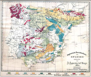
خواكين إثكوِرّا دل بايو رسم أول خريطة جيولوجية لإسبانيا في 1850[6]
المنشورات
- Journal of Iberian Geology ISSN 1886-7995 was originally called Cuadernos de Geología Ibérica and began publication in 1970. It was renamed in 1999.
- IGME Instituto Geológico y Minero de España: geological maps — registration required.
- Geogaceta from Sociedad Geológica de España
- Estudios Geológicos started publication in 1945, edited by the Spanish Research Council and published by the Museo Nacional de Ciencias Naturales.
- "TOPO-EUROPE: the Geoscience of Coupled Deep Earth – Surface Processes: 3.4. In Front of the Africa-Europe Collision Zone: the Iberian Microcontinent".
المراجع
- M. Julivert, F. J. Martinez and A. Ribeiro, The Iberian segment of the European Hercynian foldbelt, in Geology of Europe from Precambrian to the post-Hercynian sedimentary basins Bureau de Recherches Gélogiques et Minières Société Géologique du Nord pp132–158 1980
- ^ Molina, Eustoquio; Laia Alegret; Estibaliz Apellaniz; Gilen Bernaola; Fernando Caballero; Jaume Dinarès-Turell; Jan Hardenbol; Claus Heilmann-Clausen; Juan C. Larrasoana; Hanspeter Luterbacher; Simonetta Monechi; Silvia Ortiz; Xabier Orue-Etxebarria; Aitor Payros; Victoriano Pujalte; Francisco J. Rodríguez-Tobar; Flavia Tori; Josep Tosquella; Alfred Uchman (2011). "The Global Stratotype Section and Point (GSSP) for the base of the Lutetian Stage at the Gorrondatxe section, Spain" (PDF). Episodes. 34 (2): 86–108. Retrieved 14 September 2012.
- ^ أ ب Schmitz, B.; Pujalte, V.; Molina, E.; Monechi, S.; Orue-Etxebarria, X.; Speijer, R. P.; Alegret, L.; Apellaniz, E.; Arenillas, I.; Aubry, M.-P.; Baceta, J.-I.; Berggren, W. A.; Bernaola, G.; Caballero, F.; Clemmensen, A.; Dinarès-Turell, J.; Dupuis, C.; Heilmann-Clausen, C.; Orús, A. H.; Knox, R.; Martín-Rubio, M.; Ortiz, S.; Payros, A.; Petrizzo, M. R.; von Salis, K.; Sprong, J.; Steurbaut, E.; Thomsen, E. (2011). "The global Stratotype Sections and Points for the bases of the Selandian (Middle Paleocene) and Thanetian (Upper Paleocene Paleocene) stages at Zumaia, Spain". Episodes. 34 (4): 220–243.
- ^ "Global Boundary Stratotype Section and Point". International Commission of Stratigraphy. Archived from the original on 15 November 2012. Retrieved 14 September 2012.
{{cite web}}: Unknown parameter|deadurl=ignored (|url-status=suggested) (help) - ^ Pavia, G.; R. Enay (March 1997). "Definition of the Aalenian–Bajocian Stage boundary" (PDF). Episodes. 20 (1): 16–22. Archived from the original (PDF) on 4 March 2016. Retrieved 6 December 2015.
{{cite journal}}: Unknown parameter|deadurl=ignored (|url-status=suggested) (help) - ^ Cresta, S.; A. Goy; S. Ureta; C. Arias; E. Barrón; J. Bernad; M. L. Canales; F. García-Joral; E. García-Romero; P. R. Gialanella; J. J. Gómez; J. A. González; C. Herrero; G. Martínez; M. L. Osete; N. Perilli; J. J. Villalaín (2001). "The Global Boundary Stratotype Section and Point (GSSP) of the Toarcian-Aalenian Boundary (Lower-Middle Jurassic)" (PDF). Episodes. 24 (3): 166–175. Retrieved 17 September 2012.
- ^ أ ب C. Virgili, Lyell and the Spanish Geology, Geologica Acta, Vol.5, Nº 1, 2007, 119-126
