وليام سميث (جيولوجي)
ولـيـام سـمـيث William Smith | |
|---|---|
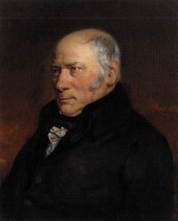 وليام سميث | |
| وُلِدَ | 23 مارس 1769 |
| توفي | 28 أغسطس 1839 (aged 70) |
| القومية | إنگليزي |
| عـُرِف بـ | خريطة جيولوجية |
| الجوائز | وسام ولاستون (1831) |
| السيرة العلمية | |
| المجالات | جيولوجيا |
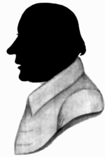
وليام 'ستراتا' سميث William 'Strata' Smith (عاش 23 مارس 1769 - 28 أغسطس 1839) كان جيولوجيا إنگليزياً، يعود إليه فضل رسم أول خريطة جيولوجية لدولة كاملة. ويُعرف بلقب "أبو الجيولوجيا الإنگليزية" لجمعه التاريخ الجيولوجي لـإنگلترة وويلز في وثيقة واحدة، بالرغم من أن الاعتراف بفضله تأخر كثيراً. فحين نشر خريطته لأول مرة لم يعره المجتمع العلمي انتباهاً؛ فتعليمه المتواضع وقلة صلاته العائلية منعته من الاختلاط بسهولة في مجتمع المتعلمين. وتلا ذلك السطو على أعماله، فزاد ذلك من مشاكله المالية، وأمطضى بعض الوقت في سجن المديونين. فقط في مرحلة متأخرة من حياته، حصل سميث على اعتراف بإنجازاته.
حقق وليام سميث W. Smith - الملقب ب"ستراتا سميث" طبقات جيولوجية Strata Smith - شهرة لبحثه المركز الذي لا يزيد عن خمس عشرة صفحة والذي يحمل عنوان خريطة جيولوجية لإنجلترا وويلز ويظهر هذا البحث أن طبقات جيولوجية تتجه تدريجيا نحو الشرق صاعدة حتى تصل في النهاية إلى سطح الأرض، وتقدم لنا في أثناء اتجاهها الصاعد أشكال الحياة في العصور الجيولوجية السابقة كما تظهر في المتحجرات الحيوانية والنباتية في العصور الجيولوجية المختلفة، وقد قدمت له الحكومة البريطانية راتبا سنويا مقداره مائة جنيه إسترليني مدى الحياة بدءا من عام 1831 مكافأة له لكشفه عن أسرار باطن الأرض، وتوفي وليام سميث سنة 1839.
النشر وخيبة الأمل

في 1799 وضعه سميث أول خريطة جيولوجية بمقياس رسم كبير للمنطقة حول باث، سمرست. However, in the Somerset County Agricultural Society, he found a map showing the types of soils and vegetation around Bath and their geographical extent. Importantly, the differing types were coloured. Using this technique, Smith could draw a geological map from his observations showing the outcrops of the rocks. He took a few rock types, each with its own colour. Then he estimated the boundaries of each of the outcrops of rock, filled them in with colour and ended up with a crude geological map.

وفي 1801، رسم اسكتشاً عمومياً لما سيُسمى لاحقاً "الخريطة التي غيرت العالم". فلإنه كان بلا وظيفة، فقد كان بإمكانه السفر في طول وعرض البلاد، مقابلاً شخصيات بارزة، مثل توماس كوك، أول إيرل لايستر، ودوق بدفورد.
وفي 1815 نشر أول خريطة جيولوجية لبريطانيا. وقد غطت كل إنگلترة وويلز، وأجزاء من اسكتلندة، بمقياس رسم 5 ميل للبوصة. While this was not the world's first geological map (a map of the United States by William Maclure was published six years earlier),[1][2] Smith's was the first geological map covering such a large area in detail,[3] and is one of the first stratigraphical analyses to utilize paleontological indices.[4] Conventional symbols were used to mark canals, tunnels, tramways and roads, collieries, lead, copper and tin mines, together with salt and alum works. The various geological types were indicated by different colours, applied by hand. Nevertheless, the map is remarkably similar to modern geological maps of England. It also included a 'Sketch of the succession of STRATA and their relative Altitudes'. This geological cross-section was not a new technique in itself, but its appearance on a map, with the clear intention of illustrating the relationship between relief and rocks and their structure, was novel.[5] He published his Delineation of the Strata of England in the same year.[6]
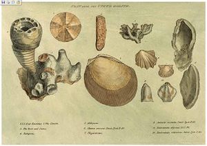
In another of his books Strata Identified by Organized Fossils (London 1816–1819), he recognised that strata contained distinct fossil assemblages which could be used to match rocks across regions (Smith's laws).[7] In 1817 he drew a remarkable geological section from Snowdon to London, a development of the ‘sketch’ on his map, illustrating the three-dimensional relationship between geology and landscape via a perspective sketch of the landscape showing the topography. Effectively this was the first block diagram, now routinely used in geography textbooks and animations.[8]
A common narrative in some recent accounts of Smith’s life and his map asserts that rivalry built up between Smith and the first President of the Geological Society, George Bellas Greenough, who was also engaged in producing a geological map of England and Wales.[9][10][11] However original sources point to this narrative not being the case and indicate Smith was used by John Farey Sr., another 'practical man' (i.e. mineral surveyor), to prosecute Farey's own grievances against the Geological Society in an article in The Philosophical Magazine by which he both started and fuelled the story that Smith was disrespected and there was ill-feeling towards him by the Geological Society men and Greenough in particular.[12] In the following issue Greenough replied, publicly declaring his view as being non-antagonistic by stating:
Your correspondent considers me, in common with many other persons, actuated by feelings of hostility towards Mr. Smith. Now my feelings towards that gentleman are directly the reverse. I respect him for the important services he has rendered to geology, and I esteem him for the example of dignity, meekness, modesty, and candour, which he continually, though ineffectually, exhibits to his self-appointed champion.[13]
Another common but misleading narrative in some recent accounts of Smith’s map has Greenough's 1820 map undercutting the price and sales of Smith's map, thereby citing Greenough as a primary cause of landing Smith in debtor's prison. However, Greenough's map could not have contributed to the debts for which Smith was consigned to prison as the Greenough map, although dated 1819 on the map, was not published until May 1820, after Smith's incarceration. In fact Smith's maps retailed at 5 guineas, which was the same price as that privileged to Geological Society members for purchase of the Greenough 1820 map. However the Greenough map retailed to public at 6 guineas, thereby being a more expensive purchase than Smith’s map.[14] Also, although neither map sold well, the number of sales of Smith's map appears to have topped those of Greenough's map (only 196 copies recorded as sold) and there are only 15 names in common between Smith's subscribers' list and the list of those who bought the Geological Society's map.[15]
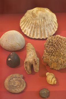
Smith's various projects, starting with a mortgage taken to purchase his estate at Tucking Mill in Somerset in 1798, accrued financial commitments that ran into a series of difficulties which he managed to withstand by borrowing money from sympathetic creditors and mortgagors and funding repayments by taking on a relentless schedule of work commissions between 1801 and 1819. However a project to quarry Bath Stone near his property, for sale to the London property development market, failed to return the significant investment it had required due to poor quality stone and Smith found himself in default to co-investor Charles Conolly. Smith had used his Bath estate as security against Conolly's loan but there was excess to pay. In attempting to stave off his debt Smith sold his 'fossil collection' to the British Museum for £700,[16] but this proved insufficient and funds fell short of the sum owed to Conolly by £300 and as a consequence Smith was sent to debtors' prison in 1819. Through all this financial turmoil, Smith managed to publish his map and subsequent associated publications but in 1817 he remarked "My income is as yet not anywise improved by what has been done, the profits being required to liquidate the debt incurred by publication."[17]
On 31 August 1819 Smith was released from King's Bench Prison in London, a debtor's prison.[18] He returned to 15 Buckingham Street, his home since 1804, to find a bailiff at the door and his home and property seized. Smith then worked as an itinerant surveyor for many years until one of his employers, Sir John Johnstone, recognised his work and talent and took steps to gain for him the respect he deserved, appointing Smith as Land Steward to his estate in Hackness near Scarborough. Between 1824 and 1834 Smith lived and was based in Hackness, then moving to Scarborough where he was responsible for the design of the Rotunda, a geological museum devoted to the Yorkshire coast, creating the cylindrical layout and arrangement of fossil display on sloping shelves.
اعتراف لاحق بفضله
It was not until February 1831 that the Geological Society of London conferred on Smith the first Wollaston Medal in recognition of his achievement.[19] It was on this occasion that the President, Adam Sedgwick, referred to Smith as "the Father of English Geology". That year Smith was awarded a pension of £100 a year by King William IV.[20] In 1835 Smith travelled to Dublin for the meeting of the British Association, and there unexpectedly received an honorary Doctorate of Laws (LL.D.) from Trinity College.[21]
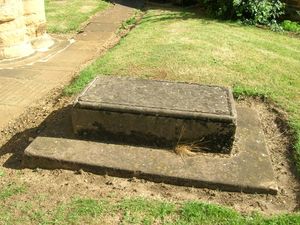
In 1838 Smith was appointed as one of the commissioners to select building-stone for the new Palace of Westminster. He died in Northampton, and is buried a few feet from the west tower of St Peter's Church, Northampton, now a redundant church. The inscription on the grave is badly worn but the name "William Smith" can just be seen. Inside St Peter’s Church is an impressive bust and inscription.
Subsequent modern geological maps have been based on Smith's original work, of which several copies have survived[22] including one which has been put on display (alongside the Greenough map) at the Geological Society of London which can be visited by the public, free and without an appointment.[23]
ذكراه
- The first geological map of most of Great Britain, much copied in his time, and the basis for all others.
- Geological surveys around the world owe a debt to his work.
- His nephew John Phillips lived during his youth with William Smith and was his apprentice. John Phillips became a major figure in 19th century geology and paleontology—among other things he is credited as first to specify most of the table of geological eras that is used today (1841).
- A crater on Mars is named after him. (see List of craters on Mars: O-Z#S)
- The Geological Society of London presents an annual lecture in his honour.
- In 2005, a William Smith 'facsimile' was created at the Natural History Museum as a notable gallery character to patrol its displays; others were Carl Linnaeus, Mary Anning, and Dorothea Bate.[24]
- His work was an important foundation for the work of Charles Darwin.
- The Rotunda Museum in Scarborough was re-opened as 'Rotunda – The William Smith Museum of Geology', on 9 May 2008 by Lord Oxburgh; however, the Prince of Wales visited the Rotunda as early as 14 September 2007 to view the progress of the refurbishment of this listed building.
- A building at Keele University containing the Geography, Geology and the Environment department is named after two William Smiths, both influential in the development of mapping. The first William Smith (1546?–1618) laid the foundations of the conventions of county mapping and of urban cartography. The second William Smith commemorated in the building's name is William Smith the author of the first geological map of England and Wales and subject of this article.[25]
طالع أيضاً
الهامش
- ^ 1911 Encyclopædia Britannica
- ^ Greene, J.C. and Burke, J.G. (1978) “The Science of Minerals in the Age of Jefferson”. Transactions of the American Philosophical Society, New Series, Vol. 68, No. 4, pp. 1–113 [39]
- ^ "William Smith's Geological Map of England". Earth Observatory. NASA. 10 May 2008. Retrieved 23 February 2013.
- ^ Gillispie, Charles Coulston (1960). The Edge of Objectivity: An Essay in the History of Scientific Ideas. Princeton University Press. p. 295. ISBN 0-691-02350-6.
- ^ Hawley, Duncan (2016). "Spotlight on William Smith's 1815 geological map: 'A delineation of the strata of England and Wales with part of Scotland...'". Geography. 101(part1): 35–41. doi:10.1080/00167487.2016.12093981.
- ^ "William "Strata" Smith (1769–1838)". HoG Biographies. Retrieved 23 February 2013.
- ^ Palmer, Douglas (2005). Earth Time: Exploring the Deep Past from Victorian England to the Grand Canyon. Wiley. ISBN 978-0470022214.
- ^ Hawley, Duncan (2016). "Spotlight on William Smith's 1815 geological map: 'A delineation of the strata of England and Wales with part of Scotland ...'". Geography. 101(part1): 35–41. doi:10.1080/00167487.2016.12093981.
- ^ Winchester, Simon (2001). The Map That Changed the World: William Smith and the Birth of Modern Geology. Viking Penguin. ISBN 978-0-670-88407-0.
- ^ "Map Collections". Lapworth Museum of Geology. University of Birmingham. Retrieved 10 February 2018.
- ^ "Lot 121, Greenough (George Bellas), A Geological Map of England & Wales by G. B. Greenough Esq. F.R.S., President of the Geological Society, published by the Geological Society, 2nd edition, November 1st. 1839". Dominic Winter Auctions Printed Books, Maps & Documents 31 January 2018. Dominic Winter Auctions. Retrieved 10 February 2018.
- ^ Farey, John Sen Mineral Surveyor (1819). "Free remarks on the Geological work of Mr Greenough". Philosophical Magazine. 54 (256): 127–132. doi:10.1080/14786441908652198.
- ^ Greenough, G.B. (1819). "Observations on certain free remarks by Mr. Farey published in the last number of the Philosophical Magazine". Philosophical Magazine. 54 (257): 205–206. doi:10.1080/14786441908652212.
- ^ Minutes of 7 January. Geological Society. 1820.
- ^ Sharpe, Tom (2016). "William Smith's 1815 Map, a delineation of the strata of England and Wales: its production, distribution,variants and survival". Earth Sciences History. 35 (1): 47–61. doi:10.17704/1944-6187-35.1.1.
- ^ Eyles, Joan (1967). "William Smith: The sale of his geological collection to the British museum". Annals of Science. 23 (3): 177–212. doi:10.1080/00033796700203276.
- ^ Torrens, Hugh (2016). "William Smith (1769–1839): His struggles as a consultant, in both geology and engineering, to simultaneously earn a living and finance his scientific projects to 1820". Earth Sciences History. 35 (1): 1–46. doi:10.17704/1944-6187-35.1.1.
- ^ Randy Moore, Mark D. Decker, More Than Darwin: An Encyclopedia of the People and Places of the Evolution-creationism Controversy, p. 327, Greenwood Press, 2008 ISBN 978-0313341557.
- ^ "November 1826 – June 1833". Proceedings of the Geological Society of London. I: 271. 1834. Retrieved 13 March 2015.
- ^ Palmer, D. An unsung hero put on the map. Nature 412, 120 (2001). https://doi.org/10.1038/35084114
- ^ British Association at Dublin in 1835. Nature 136, 232–233 (1935). https://doi.org/10.1038/136232b0
- ^ Eyles, V.A; Eyles, Joan M. (1938). "On the different issues of the first geological map of England and Wales". Annals of Science. 3 (2): 190–212. doi:10.1080/00033793800200871.
- ^ "Visiting the William Smith Map". Geological Society of London. Retrieved 2 October 2022.
- ^ Review by Miles Russell of Discovering Dorothea by Karolyn Shindler at ucl.ac.uk (accessed 23 November 2007)
- ^ "William Smith Building". History in Keele Buildings. Keele University. Retrieved 10 February 2018.
مصادر أخرى
- John L Morton, Strata (New Edition, 2004), Horsham: Brocken Spectre Publishing. ISBN 0-9546829-1-2
- Simon Winchester, The Map That Changed the World: William Smith and the Birth of Modern Geology, (2001), New York: HarperCollins, ISBN 0-14-028039-1
- John Phillips, Memoirs of William Smith (1844, republished with additional material by Hugh Torrens, 2003 ISBN 0-9544941-0-5).
- William Smith's Private Papers, Oxford University
- A.Taylor, "A History of the Taylor Family", (1986), Privately Published.
وصلات خارجية
- William Smith — a man who changed the world
- Biography of William "Strata" Smith.
- William "Strata" Smith and his achievements in Scarborough.
- Image of Smith's geological map of England and Wales and part of Scotland, published in 1815.
- Full-size replica of Smith's map at the Durham campus of the University of New Hampshire.
- NASA Earth Observatory biography
- NASA Earth Observatory page on William Smith's Geological Map
- Works of William Smith at the Oxford Digital Library

