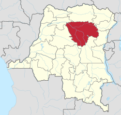
محافظة تشوپو
Tshopo Province | |
|---|---|
| Province de la Tshopo | |
 | |
| الإحداثيات: 0°31′N 25°12′E / 0.517°N 25.200°E | |
| Country | |
| Established | 2015 |
| السمِيْ | Tshopo River |
| Capital | Kisangani |
| الحكومة | |
| • Governor | Abibu Sakapela Bin Mungamba[1] |
| المساحة | |
| • الإجمالي | 199٬567 كم² (77٬053 ميل²) |
| التعداد (2005 est.) | |
| • الإجمالي | 2٬614٬630 |
| • الكثافة | 13/km2 (34/sq mi) |
| منطقة التوقيت | UTC+2 (Central Africa Time) |
| License Plate Code | |
| Official language | French |
| الموقع الإلكتروني | latshopo |
تشوپو Tshopo، هي محافظة في جمهورية الكونغو الديمقراطية وعاصمتها مدينة كيسانگاني.
Tshopo, Bas-Uele, Haut-Uele, and Ituri provinces are the result of the dismemberment of the former Orientale province.[2] Tshopo was formed from the Tshopo district and the independently administered city of Kisangani which retained its status as a provincial capital.
. . . . . . . . . . . . . . . . . . . . . . . . . . . . . . . . . . . . . . . . . . . . . . . . . . . . . . . . . . . . . . . . . . . . . . . . . . . . . . . . . . . . . . . . . . . . . . . . . . . . . . . . . . . . . . . . . . . . . . . . . . . . . . . . . . . . . . . . . . . . . . . . . . . . . . . . . . . . . . . . . . . . . . . .
التاريخ
From 1963 to 1966, the area was constituted as the province of Haut-Congo. It was merged into Orientale Province in 1966 as, separately, the District of Tshopo and the city of Kisangani. The Presidents (later governors) of Haut-Congo were:
- 1963 – 26 June 1963: Georges Grenfell (و. 1908)
- 26 June 1963 – 1964: Paul Isombuma
- 1964 – August 1964: François Aradjabu
- August 1964 – 5 Nov 1966: Jean Marie Alamazani
Provincial status was re-instated to Tshopo in 2015, being formed from Tshopo District and the city of Kisangani.[3]
التناظر التقريبي بين المحافظتين التاريخية والحالية
| الكونغو البلجيكي | جمهورية الكونغو | زائير | جمهورية الكونغو الديمقراطية | ||||||
|---|---|---|---|---|---|---|---|---|---|
| 1908 | 1919 | 1932 | 1947 | 1963 | 1966 | 1971 | 1988 | 1997 | 2015 |
| 22 districts | 4 مقاطعات | 6 مقاطعات | 6 مقاطعات | 21 مقاطعات + العاصمة | 8 مقاطعات + العاصمة | 8 مقاطعات + العاصمة | 11 مقاطعة | 11 مقاطعة | 26 مقاطعة |
| Bas-Uele | Orientale | ستانليڤيل | Orientale | Uele | Orientale | زائير العليا | Orientale | Bas-Uele | |
| Haut-Uele | Haut-Uele | ||||||||
| Ituri | Kibali-Ituri | إيتوري | |||||||
| Stanleyville | الكونغو الأعلى | تشوپو | |||||||
| Aruwimi | |||||||||
| Maniema | Costermansville | كيڤو | Maniema | كيڤو | Maniema | ||||
| Lowa | |||||||||
| كيڤو | شمال كيڤو | شمال كيڤو | |||||||
| وسط كيڤو | جنوب كيڤو | ||||||||
الأقاليم
The provincial capital is the city of Kisangani. Territories are:[4]
المدينة
المقاطعات
المراجع
- ^ "Congo (Kinshasa) provinces". Rulers. Retrieved 9 July 2019.
- ^ "Découpage territorial : procédures d'installation de nouvelles provinces". Radio Okapi (in الفرنسية). 13 July 2015. Archived from the original on 19 July 2015. Retrieved 5 June 2020.
- ^ "Provinces of the Democratic Republic of Congo". Statiods.com.
- ^ Blaes, X. (October 2008). "Découpage administratif de la République Démocratique du Congo" (PDF). PNUD-SIG. Archived from the original (PDF) on 2010-04-01. Retrieved 2011-12-09.
وصلات خارجية
- Provinceorientale.cd the Government official site for Orientale Province.
- Stanleyville.be City of Kisangani Website.
- Bamanisajean.unblog.fr is Governor Jean Bamanisa's blog site.
- @Prov_orientale Twitter for Orentale Provincial Government
- Facebook Orentale Provincial Government
