تنافلاي، نيوجرزي
تنافلاي، نيوجرزي
Tenafly, New Jersey | |
|---|---|
| Borough of Tenafly | |
 | |
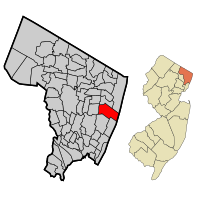
 خريطة تبين موقع تنافلاي ضمن مقاطعة برگن. الصورة الداخلية: موقع مقاطعة برگن ضمن نيوجرزي | |
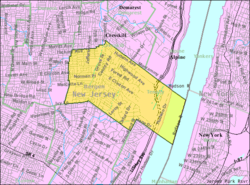
 Census Bureau map of Tenafly, New Jersey | |
| الإحداثيات: 40°55′06″N 73°57′02″W / 40.918309°N 73.950521°W[1][2] | |
| البلد | |
| State | |
| المقاطعة | برگن |
| Incorporated | January 24, 1894 |
| الحكومة | |
| • النوع | Special Charter |
| • الكيان | مجلس الحي |
| • العمدة | Peter S. Rustin (I, term ends December 31, 2019)[3][4] |
| • Administrator | Jewel V. Thompson-Chin[5] |
| • Municipal clerk | Lissette Aportela[6] |
| المساحة | |
| • الإجمالي | 5٫184 ميل² (13٫428 كم²) |
| • البر | 4٫601 ميل² (11٫917 كم²) |
| • الماء | 0٫583 ميل² (1٫510 كم²) 11.25% |
| ترتيب المساحة | 272nd of 566 in state 12th of 70 in county[1] |
| المنسوب | 217 ft (66 m) |
| التعداد | |
| • الإجمالي | 14٬488 |
| • Estimate (2016)[12] | 14٬846 |
| • الترتيب | 172nd of 566 in state 21st of 70 in county[13] |
| • الكثافة | 3٬148٫6/sq mi (1٬215٫7/km2) |
| • ترتيب الكثافة | 206th of 566 in state 43rd of 70 in county[13] |
| منطقة التوقيت | UTC−5 (Eastern (EST)) |
| • الصيف (التوقيت الصيفي) | UTC−4 (Eastern (EDT)) |
| ZIP code | |
| مفتاح الهاتف | 201[16] |
| FIPS code | 3400272420[1][17][18] |
| GNIS feature ID | 0885417[1][19] |
| الموقع الإلكتروني | www |
تنافلاي Tenafly ؛ /ˈtɛnəflaɪ/ هي حي في مقاطعة برگن، نيوجرزي، الولايات المتحدة. اعتبارًا من تعداد 2010 ، كان عدد سكان البلدة 14،488، [9][10][11] مما يعكس زيادة قدرها 682 (+ 4.9٪) من 13806 تم احتسابها في تعداد 2000 ، والتي زادت بدورها بمقدار 480 (+ 3.6٪) من 13326 تم احتسابها في تعداد 1990.[20] تنافلاي هي ضاحية من ضواحي مدينة نيويورك.
أول المستوطنين الأوروبيين في تنافلاي كانوا الهولنديين المهاجرين ، الذين بدأوا في ملء المنطقة خلال أواخر القرن السابع عشر. اسم "تنافلاي" نفسه مشتق من العبارة الحديثة المبكرة من الهولندية "فلاي" أو "عشرة مستنقعات" التي أطلقها المستوطنون الهولنديون في عام 1688.[21][22] والاشتقاقات الأخرى للكلمة تشير إلى ربط اللغة الهولندية موقعها في مرج. [23][24]
تم دمج تنافلاي كمنطقة إدارية في 24 يناير 1894، بموجب قانون من الهيئة التشريعية في نيو جيرسي من أجزاء من بلدة باليسادس, بناءً على نتائج الاستفتاء الذي تم إجراؤه في اليوم السابق.[25][26] كانت هذه البلدة هي أول منطقة تشكلت خلال ظاهرة "بوروييتس" للأحياء السكنية ثم اجتاحت مقاطعة بيرغن ، حيث تم تشكيل 26 منطقة في المقاطعة في عام 1894 وحده.[27] تم الاستحواذ على أجزاء من بلدة باليسادس بناءً على تشريع تمت الموافقة عليه في 8 أبريل 1897.[25][28]
صنفت مجلة نيوجرزي الشهرية تنافلاي أفضل مكان للعيش في نيو جيرسي في تصنيفها لعام 2013 لـ "أفضل الأماكن للعيش" في نيوجرزي. [29]
. . . . . . . . . . . . . . . . . . . . . . . . . . . . . . . . . . . . . . . . . . . . . . . . . . . . . . . . . . . . . . . . . . . . . . . . . . . . . . . . . . . . . . . . . . . . . . . . . . . . . . . . . . . . . . . . . . . . . . . . . . . . . . . . . . . . . . . . . . . . . . . . . . . . . . . . . . . . . . . . . . . . . . . .
ديمغرافيا
| التعداد التاريخي | |||
|---|---|---|---|
| التعداد | Pop. | %± | |
| 1880 | 1٬019 | — | |
| 1890 | 1٬046 | 2٫6% | |
| 1900 | 1٬746 | 66٫9% | |
| 1910 | 2٬756 | 57٫8% | |
| 1920 | 3٬585 | 30٫1% | |
| 1930 | 5٬669 | 58٫1% | |
| 1940 | 7٬413 | 30٫8% | |
| 1950 | 9٬651 | 30٫2% | |
| 1960 | 14٬264 | 47٫8% | |
| 1970 | 14٬827 | 3٫9% | |
| 1980 | 13٬552 | −8٫6% | |
| 1990 | 13٬326 | −1٫7% | |
| 2000 | 13٬806 | 3٫6% | |
| 2010 | 14٬488 | 4٫9% | |
| 2016 (تق.) | 14٬846 | [12][30] | 2٫5% |
| مصادر التعداد: 1880-1890[31] 1890–1920[32] 1890–1910[33] 1910–1930[34] 1900–2010[35][36][37] 2000[38][39] 2010[9][10][11] | |||
2010 Census
في تعداد الولايات المتحدة 2010 كان هناك 14٬488 شخص 4٬766 أسرة و3٬956 أسرة تقيم في borough. كانت الكثافة السكانية 3,148.6 inhabitants per square mile (1,215.7/km2). كان هناك 4٬980 وحدة سكنية في المناطق متوسط كثافتها السكانية 1,082.3 per square mile (417.9/km2)*. كانت التركيبة العرقية borough 69.31% (10٬041) من البيض، 0.88% (128) من الأفارقة الأمريكان، 0.03% (5) من الأمريكان الأصليين، 26.22% (3٬799) من الآسيويين، 0.00% (0) من سكان جزر الهادي، 1.23% (178) من عرقيات أخرى، و2.33% (337) من عرقين أو أكثر. الهسپان واللاتينيين من أي عرقية أخرى كانوا 5.36% (776) من تعداد السكان.[9]
كان هناك 4٬766 أسرة، منهم 49.1% لديهم أطفال أقل من 18 سنة يعيشون معهم، 72.7% متزوجين يعيشون معاً، 8.2% سيدات يعلن الأسرة وزوجن غائب، و17.0% منهم غير عائلات. 15.3% من إجمالي الأسر يتكونون من أفراد و8.7% عبارة عن أشخاص يعيشون بمفردههم يتجاوز سنهم 65 أو أكثر. كان متوسط حجم الأسرة 3.02 ومتوسط حجم العائلة 3.36.[9]
فيما يخص الفئة العمرية لسكان البلدة، كان هناك borough، 31.2% تحت 18 سنة 5.0% من 18 - 24، 20.2% من 25 - 44، 30.2% من 45 - 64، و13.5% ي سن 65 أو أكبر. متوسط عمر السكان 41.8 سنة. لكل إناث كان هناك 93.4 ذكر. لكل 100 أنثى في سن 18 سنة أو أكثر هناك 87.6 ذكر.[9]
الاقتصاد
المراجع
- ^ أ ب ت ث ج 2010 Census Gazetteer Files: New Jersey County Subdivisions, United States Census Bureau. Accessed May 21, 2015.
- ^ US Gazetteer files: 2010, 2000, and 1990, United States Census Bureau. Accessed September 4, 2014.
- ^ خطأ استشهاد: وسم
<ref>غير صحيح؛ لا نص تم توفيره للمراجع المسماةMayorCouncil - ^ 2017 New Jersey Mayors Directory, New Jersey Department of Community Affairs. Accessed May 30, 2017.
- ^ Office of the Borough Administrator, Borough of Tenafly. Accessed June 17, 2016.
- ^ Borough Clerk, Borough of Tenafly. Accessed June 17, 2016.
- ^ خطأ استشهاد: وسم
<ref>غير صحيح؛ لا نص تم توفيره للمراجع المسماةDataBook - ^ U.S. Geological Survey Geographic Names Information System: Borough of Tenafly, Geographic Names Information System. Accessed March 14, 2013.
- ^ أ ب ت ث ج ح DP-1 - Profile of General Population and Housing Characteristics: 2010 for Tenafly borough, Bergen County, New Jersey, United States Census Bureau. Accessed January 21, 2012.
- ^ أ ب ت خطأ استشهاد: وسم
<ref>غير صحيح؛ لا نص تم توفيره للمراجع المسماةDistricts2011 - ^ أ ب ت Profile of General Demographic Characteristics: 2010 for Tenafly borough Archived 2012-04-02 at the Wayback Machine, New Jersey Department of Labor and Workforce Development. Accessed November 7, 2011.
- ^ أ ب PEPANNRES - Annual Estimates of the Resident Population: April 1, 2010 to July 1, 2016 - 2016 Population Estimates for New Jersey municipalities, United States Census Bureau. Accessed June 16, 2017.
- ^ أ ب GCT-PH1 Population, Housing Units, Area, and Density: 2010 - State -- County Subdivision from the 2010 Census Summary File 1 for New Jersey, United States Census Bureau. Accessed August 11, 2013.
- ^ Look Up a ZIP Code, United States Postal Service. Accessed November 7, 2011.
- ^ Zip Codes, State of New Jersey. Accessed August 29, 2013.
- ^ Area Code Lookup - NPA NXX for Tenafly, NJ, Area-Codes.com. Accessed August 29, 2013.
- ^ American FactFinder, United States Census Bureau. Accessed September 4, 2014.
- ^ A Cure for the Common Codes: New Jersey, Missouri Census Data Center. Accessed July 30, 2012.
- ^ US Board on Geographic Names, United States Geological Survey. Accessed September 4, 2014.
- ^ Table 7. Population for the Counties and Municipalities in New Jersey: 1990, 2000 and 2010 Archived 2013-05-20 at the Wayback Machine, New Jersey Department of Labor and Workforce Development, February 2011. Accessed July 30, 2012.
- ^ O'Connor, Ian. If You're Thinking of Living in: Tenafly, The New York Times, April 24, 1988. Accessed July 30, 2012. "Tenafly, named Tiene Vly (Ten Swamps) by Dutch settlers in 1688, is home to people who work in the city but want a respite from the daily urban grind."
- ^ Carpenter, Wm. H. "Two Words of Dutch Origin", Modern Language Notes', June 1886. Accessed February 12, 2010.
- ^ Hutchinson, Viola L. The Origin of New Jersey Place Names, New Jersey Public Library Commission, May 1945. Accessed October 11, 2015.
- ^ Gannett, Henry. The Origin of Certain Place Names in the United States, p. 298. United States Government Printing Office, 1905. Accessed October 11, 2015.
- ^ أ ب Snyder, John P. The Story of New Jersey's Civil Boundaries: 1606-1968, Bureau of Geology and Topography; Trenton, New Jersey; 1969. p. 87. Accessed July 30, 2012.
- ^ About Tenafly Archived 2006-09-01 at the Wayback Machine, accessed September 7, 2006.
- ^ Harvey, Cornelius Burnham. Genealogical History of Hudson and Bergen Counties, New Jersey, p. 11, New Jersey Genealogical Publishing Company, 1900. Accessed September 1, 2013. "For a period of sixteen years following the passage of this act few boroughs were organized in the State, only three of them being in Bergen County.... As it was twenty-six boroughs were in the county from January 23, 1894, to December 18, of the same year." Note that the source incorrectly lists June 23, 1894, as the borough's formation date, even though the borough is listed correctly in chronological order.
- ^ Honeyman, Abraham Van Doren. Index-analysis of the Statutes of New Jersey, 1896-1909: Together with References to All Acts, and Parts of Acts, in the 'General Statutes' and Pamphlet Laws Expressly Repealed: and the Statutory Crimes of New Jersey During the Same Period, p. 287. New Jersey Law Journal Publishing Company, 1910. Accessed October 11, 2015.
- ^ Staff. Best Places to Live in New Jersey 2013, New Jersey Monthly, August 16, 2013. Accessed November 12, 2014.
- ^ Census Estimates for New Jersey April 1, 2010 to July 1, 2016, United States Census Bureau. Accessed June 16, 2017.
- ^ Report on Population of the United States at the Eleventh Census: 1890. Part I, p. 238. United States Census Bureau, 1895. Accessed October 20, 2016.
- ^ Compendium of censuses 1726-1905: together with the tabulated returns of 1905, New Jersey Department of State, 1906. Accessed August 11, 2013.
- ^ Thirteenth Census of the United States, 1910: Population by Counties and Minor Civil Divisions, 1910, 1900, 1890, United States Census Bureau, p. 335. Accessed July 30, 2012.
- ^ Fifteenth Census of the United States : 1930 - Population Volume I, United States Census Bureau, p. 714. Accessed January 21, 2012.
- ^ Table 6. New Jersey Resident Population by Municipality: 1930 - 1990 Archived 2015-05-10 at the Wayback Machine, New Jersey Department of Labor and Workforce Development. Accessed August 9, 2016.
- ^ Bergen County Data Book 2003 Archived 2013-07-24 at the Wayback Machine, Bergen County, New Jersey. Accessed July 21, 2013.
- ^ Historical Population Trends in Bergen County (1900-2010), Bergen County Department of Planning & Economic Development, 2011. Accessed June 28, 2015.
- ^ خطأ استشهاد: وسم
<ref>غير صحيح؛ لا نص تم توفيره للمراجع المسماةCensus2000 - ^ خطأ استشهاد: وسم
<ref>غير صحيح؛ لا نص تم توفيره للمراجع المسماةCensus2000SF1
Sources
- Municipal Incorporations of the State of New Jersey (according to Counties) prepared by the Division of Local Government, Department of the Treasury (New Jersey); December 1, 1958.
- Clayton, W. Woodford; and Nelson, William. History of Bergen and Passaic Counties, New Jersey, with Biographical Sketches of Many of its Pioneers and Prominent Men., Philadelphia: Everts and Peck, 1882.
- Harvey, Cornelius Burnham (ed.), Genealogical History of Hudson and Bergen Counties, New Jersey. New York: New Jersey Genealogical Publishing Co., 1900.
- Rigney, Alice Renner; and Stefanowicz, Paul J. Images of America: Tenafly, Arcadia Publishing, 2009. ISBN 9780738562247.
- Van Valen, James M. History of Bergen County, New Jersey. New York: New Jersey Publishing and Engraving Co., 1900.
- Westervelt, Frances A. (Frances Augusta), 1858–1942, History of Bergen County, New Jersey, 1630-1923, Lewis Historical Publishing Company, 1923.
وصلات خارجية
- NorthJersey.com - Tenafly
- Tenafly official website
- Tenafly Public Schools
- Tenafly Public Schools's 2012–13 School Report Card from the New Jersey Department of Education
- Data for the Tenafly Public Schools, National Center for Education Statistics
- History of Englewood, NJ's attempted school district regionalization with Tenafly, NJ
- Tenafly Nature Center
- MuniNet Guide
- Pages using gadget WikiMiniAtlas
- Short description is different from Wikidata
- Coordinates on Wikidata
- Pages using US Census population needing update
- Convert invalid options
- Tenafly, New Jersey
- 1894 establishments in New Jersey
- Boroughs in Bergen County, New Jersey
- Dutch-American culture in New Jersey
- Populated places established in 1894
- Populated places on the Hudson River
- Special Charters in New Jersey

