نظام شوشتر الهيدروليكي التاريخي
| موقع تراث عالمي حسب اليونسكو | |
|---|---|
| الموقع | مقاطعة شوشتر، محافظة خوزستان، إيران |
| السمات | ثقافي: (i), (ii), (v) |
| مراجع | 1315 |
| التدوين | 2009 (33rd Session) |
| المساحة | 240.4 ha (594 acres) |
| منطقة عازلة | 1,572.2 ha (3,885 acres) |
| الإحداثيات | 32°1′7″N 48°50′9″E / 32.01861°N 48.83583°E |
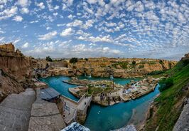
نظام شوشتر الهيدروليكي التاريخي، (فارسية: سازههای آبی شوشتر) هو نظام ري معقد للمدينة الجزيرة شوشتر من العهد الساساني، ويتكون من 13 سد وجسر وقناة ومنشأ يعملون معاً كنظام هيدروليكي.
Located in Iran's Khuzestan Province.[1][2] It was registered on UNESCO's list of World Heritage Sites in 2009 and is Iran's 10th cultural heritage site to be registered on the United Nations' list.[1][3]
Shushtar infrastructure included water mills, dams, tunnels, and canals. Gargar Bridge-Dam was built on the watermills and waterfalls. Bolayti canal is situated on the eastern side of the water mills and water falls and functions to supply water from behind the GarGar bridge to the east side of water mills and channel the water in order to prevent damage to the water mills. Dahaneye shahr tunnel (city orifice) is one of the three main tunnels which channeled the water from behind the Gargar Bridge-Dam into the water mill and then run several water mills. Seh koreh canal channels the water from behind the GarGar bridge into the western side. In the water mills and water falls, we can see a perfect model of haltering to run mills.[1][3]
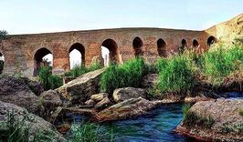
بند قيصر ("سد قيصر")، هدار روماني بالغ طوله نحو 500 متر على نهر كارون, was the key structure of the complex which, along with the Mizan Dam (Band-e Mizan), retained and diverted river water into the irrigation canals in the area.[4] Built by a Roman workforce in the 3rd century AD on Sassanid order,[5] it was the most eastern Roman bridge and Roman dam[6] and the first structure in Iran to combine a bridge with a dam.[7]
Parts of the irrigation system are said to originally date to the time of Darius the Great, an Achaemenian king of Iran. It partly consists of a pair of primary diversion canals in the Karun river, one of which is still in use today. It delivers water to the Shushtar city via a route of supplying tunnels.[1] The area includes Salasel Castle, which is the axis for operation of the hydraulic system. It also consists of a tower for water level measurement, along with bridges, dams, mills, and basins.[1][3]
Then it enters the plain south of the city, where its impact includes enabling the possibility of farming over the area called Mianâb and planting orchards.[3] In fact the whole area between the two diversion canals (Shutayt and Gargar) on Karun river is called Mianâb, an island having the Shushtar city at its northern end.[8]
The site has been referred to as "a masterpiece of creative genius" by UNESCO.[9]
. . . . . . . . . . . . . . . . . . . . . . . . . . . . . . . . . . . . . . . . . . . . . . . . . . . . . . . . . . . . . . . . . . . . . . . . . . . . . . . . . . . . . . . . . . . . . . . . . . . . . . . . . . . . . . . . . . . . . . . . . . . . . . . . . . . . . . . . . . . . . . . . . . . . . . . . . . . . . . . . . . . . . . . .
المواقع
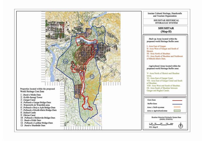
نظام شوشتر الهيدروليكي التاريخي هو مجمع من السدود والجسور والمنشآت يتألف من 13 موقعاً يعملون معاً كنظام هيدروليكي.[10][11]
1. سد ميزان
2. برج كلاه فرنگي
3. قناة گرگر
4. جسر-سد گرگر
5. منطقة طواحين ومساقط مياه
6. جسر-سد برج عيار ومقبرة الصابئة
7. جسر-سد خدا-آفرين
8. قلعة سلاسل
9. قناة داريون
10. جسر-سد شادُروان
11. سد بند خاك
12. جسر-سد لشكر
13. سد شرابدار
معرض صور
الهامش
- ^ أ ب ت ث ج UNESCO registers Iran's Shushtar water system, PressTV, Retrieved on May 1, 2010.
- ^ Shushtar Archived 2010-06-04 at the Wayback Machine, world heritage sites, retrieved on May 1, 2010.
- ^ أ ب ت ث Shushtar Historical Hydraulic System, UNESCO, Retrieved on May 1, 2010.
- ^ Length: Hodge 1992, p. 85; Hodge 2000, pp. 337f.; extensive irrigation system: O'Connor 1993, p. 130
- ^ Smith 1971, pp. 56–61; Schnitter 1978, p. 32; Kleiss 1983, p. 106; Vogel 1987, p. 50; Hartung & Kuros 1987, p. 232; Hodge 1992, p. 85; O'Connor 1993, p. 130; Huff 2010; Kramers 2010
- ^ Schnitter 1978, p. 28, fig. 7
- ^ Vogel 1987, p. 50
- ^ C. J. Edmonds, East and West of Zagros, BRILL, 2009, ISBN 9004173447; Page 157.
- ^ Check out 13 emerging wonders of the world, msn news, Retrieved on May 1, 2010.
- ^ Centre, UNESCO World Heritage. "Shushtar Historical Hydraulic System". UNESCO World Heritage Centre.
- ^ https://whc.unesco.org/document/152341
المصادر
- Hartung, Fritz; Kuros, Gh. R. (1987), "Historische Talsperren im Iran", in Garbrecht, Günther, Historische Talsperren, 1, Stuttgart: Verlag Konrad Wittwer, pp. 221–274, ISBN 3-87919-145-X
- Hodge, A. Trevor (1992), Roman Aqueducts & Water Supply, London: Duckworth, p. 85, ISBN 0-7156-2194-7
- Huff, Dietrich (2010), "Bridges. Pre-Islamic Bridges", in Yarshater, Ehsan, Encyclopædia Iranica Online
- Kleiss, Wolfram (1983), "Brückenkonstruktionen in Iran", Architectura 13: 105–112 (106)
- Kramers, J. H. (2010), "Shushtar", in Bearman, P., Encyclopaedia of Islam (2nd ed.), Brill Online
- O'Connor, Colin (1993), Roman Bridges, Cambridge University Press, p. 130 (No. E42), ISBN 0-521-39326-4
- Schnitter, Niklaus (1978), "Römische Talsperren", Antike Welt 8 (2): 25–32 (32)
- Smith, Norman (1971), A History of Dams, London: Peter Davies, pp. 56–61, ISBN 0-432-15090-0
- Vogel, Alexius (1987), "Die historische Entwicklung der Gewichtsmauer", in Garbrecht, Günther, Historische Talsperren, 1, Stuttgart: Verlag Konrad Wittwer, pp. 47–56 (50), ISBN 3-87919-145-X
وصلات خارجية
- Livius.org: Shushtar
- UNESCO: World heritage site
- Pages using gadget WikiMiniAtlas
- Short description is different from Wikidata
- Coordinates on Wikidata
- Articles containing فارسية-language text
- تاريخ محافظة خوزستان
- العمارة الساسانية
- العلوم والتقنية في إيران
- مباني ومنشآت في إيران
- Water supply and sanitation in Iran
- مواقع التراث العالمي في إيران
- مباني ومنشآت في محافظة خوزستان
- Tourist attractions in Khuzestan Province


