پريزيديو سان فرانسسكو
Presidio | |
|---|---|
 A map of the Presidio | |
| الإحداثيات: 37°47′53″N 122°27′57″W / 37.79806°N 122.46583°W | |
| Country | |
| State | |
| City-county | San Francisco |
| Fortified | September 17, 1776 |
| الحكومة | |
| • النوع | Board of Supervisors |
| المساحة | |
| • الإجمالي | 2٫347 ميل² (6٫08 كم²) |
| التعداد | |
| • الإجمالي | 799 |
| • الكثافة | 340/sq mi (130/km2) |
| منطقة التوقيت | UTC−8 (Pacific) |
| • الصيف (التوقيت الصيفي) | UTC−7 (PDT) |
| ZIP code | 94129 |
| Area codes | 415/628 |
Presidio of San Francisco | |
| المساحة | 1,480 acres (6.0 km2)[3] |
| بُنيَ | 1776 |
| المعماري | Spanish/Mexico/United States Army |
| الطراز المعماري | Spanish Colonial, Spanish Revival, Colonial Revival, Classical Revival |
| الموقع الإلكتروني | Presidio of San Francisco Presidio Trust |
| NRHP reference No. | خطأ لوا: invalid capture index %2 in replacement string. |
| CHISL No. | 79 |
| تواريخ بارزة | |
| أضيف إلى NRHP | October 15, 1966 |
| Designated NHL | June 13, 1962[5] |
| أُدرِجـَت CHISL | 1933[4] |
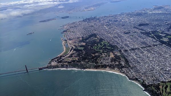
The Presidio of San Francisco (originally, El Presidio Real de San Francisco or The Royal Fortress of Saint Francis) is a park and former U.S. Army military fort on the northern tip of the San Francisco Peninsula in San Francisco, California, and is part of the Golden Gate National Recreation Area.
It had been a fortified location since September 17, 1776, when New Spain established the presidio to gain a foothold in Alta California and the San Francisco Bay. It passed to Mexico, which in turn passed it to the United States in 1848.[6] As part of a 1989 military reduction program under the Base Realignment and Closure (BRAC) process, Congress voted to end the Presidio's status as an active military installation of the U.S. Army. On October 1, 1994, it was transferred to the National Park Service, ending 219 years of military use and beginning its next phase of mixed commercial and public use.[7]
In 1996, the United States Congress created the Presidio Trust to oversee and manage the interior 80% of the park's lands, with the National Park Service managing the coastal 20%.[8] In a first-of-its-kind structure, Congress mandated that the Presidio Trust make the Presidio financially self-sufficient by 2013. The Presidio achieved the goal in 2005, eight years ahead of the scheduled deadline.[9]
The park is characterized by many wooded areas, hills, and scenic vistas overlooking the Golden Gate Bridge, San Francisco Bay, and the Pacific Ocean. It was recognized as a California Historical Landmark in 1933 and as a National Historic Landmark in 1962.[5][4]
خط زمني
التاريخ
التاريخ المبكر
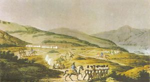
The Presidio was originally a Spanish fort sited by Juan Bautista de Anza on March 28, 1776, built by a party led by José Joaquín Moraga later that year. In 1783, the Presidio's garrison numbered only 33 men. Upon Mexican independence from Spain in 1821, it was briefly operated as a Mexican fortification.
See also
- 49-Mile Scenic Drive
- Military Districts in Spanish California
- Rancho San Ramon (Amador)
- List of beaches in California
- List of California state parks
References
- ^ أ ب "Presidio (Crissy Field) neighborhood in San Francisco, California (CA), 94129 subdivision profile". Retrieved April 9, 2015.
- ^ "National Register Information System". National Register of Historic Places. National Park Service. أبريل 15, 2008.
- ^ "Presidio of San Francisco" (PDF). National Park Service. Archived from the original (PDF) on 2009-03-25. Retrieved 2012-01-17.
- ^ أ ب قالب:Cite ohp
- ^ أ ب NHL Summary.
- ^ "Under Three Flags" (PDF). National Park Service. Retrieved 2012-01-17.
- ^ "Presidio of San Francisco Post to Park transition". National Park Service. Retrieved 2008-12-20.
- ^ "The Presidio Trust". Archived from the original on February 14, 2012.
- ^ Levy, Dan (June 19, 2005). "A Green Belt in The Black". San Francisco Chronicle. Retrieved 2008-12-20.
- National Register of Historic Places Nomination Form and accompanying photos
- [[[:قالب:NHLS url]] "Nomination Form"] (pdf). National Register of Historic Places. National Park Service. October 28, 1992.
{{cite web}}: Check|url=value (help) - [[[:قالب:NHLS url]] "Photos (78)"] (pdf). National Register of Historic Places. National Park Service. August 1990.
{{cite web}}: Check|url=value (help)
- [[[:قالب:NHLS url]] "Nomination Form"] (pdf). National Register of Historic Places. National Park Service. October 28, 1992.
External links
- The National Park Service's official site of the Presidio
- The Presidio Trust
- The National Park Service's official site of the Golden Gate Recreation Area
- Moraga's Account of the Founding of San Francisco
- Discover Our Shared Heritage "Early History of the California Coast" National Park Service
- "Juan Bautista de Anza National Historic Trail" National Park Service
- The California State Military Museum, on the Letterman Army Hospital
- El Presidio Digital Media Archive (creative commons-licensed photos, laser scans, panoramas), mainly The Officer's Club and Fort Scott, using data from a UC Berkeley/CyArk research partnership
- Things to do in Presidio of San Francisco
- Fort Point and Presidio Historical Association
- Library of Congress: Americas Memory
- Records of the Presidio Trust in the National Archives (Record Group 556)
قالب:Golden Gate National Recreation Area قالب:National Register of Historic Places in California
قالب:Neighborhoods of San Francisco قالب:California Missions
- Pages using gadget WikiMiniAtlas
- Articles using NRISref without a reference number
- Short description is different from Wikidata
- Coordinates on Wikidata
- Pages using infobox NRHP with unknown parameters
- Pages with empty portal template
- CS1 errors: URL
- Presidio of San Francisco
- Golden Gate National Recreation Area
- Parks in San Francisco
- Museums in San Francisco
- California presidios
- Forts in California
- Military facilities in the San Francisco Bay Area
- Forts on the National Register of Historic Places in California
- Military and war museums in California
- National Historic Landmarks in the San Francisco Bay Area
- National Register of Historic Places in San Francisco
- Natural history museums in California
- Open-air museums in California
- Closed installations of the United States Army
- 1776 establishments in California
- 1776 in Alta California
- San Francisco Bay Trail
- Bay Area Ridge Trail


