قاغلق (بلدة)
Kargilik Town
قاغىلىق بازىرى 喀格勒克镇 Qaghiliq, Kageleke | |
|---|---|
 | |
| الإحداثيات: 37°53′6″N 77°24′47″E / 37.88500°N 77.41306°E | |
| Country | China |
| Autonomous region | Xinjiang |
| Prefecture | Kashgar Prefecture |
| County | Kargilik County |
| المساحة | |
| • الإجمالي | 37٫5 كم² (14٫5 ميل²) |
| التعداد (2010)[2] | |
| • الإجمالي | 75٬730 |
| • الكثافة | 2٬000/km2 (5٬200/sq mi) |
| Ethnic groups | |
| • Major ethnic groups | Uyghur[3] |
| منطقة التوقيت | UTC+8 (China Standard) |
| قاغلق | |||||||||||
|---|---|---|---|---|---|---|---|---|---|---|---|
| الاسم الصيني | |||||||||||
| الصينية التقليدية | 葉城 | ||||||||||
| الصينية المبسطة | 叶城 | ||||||||||
| |||||||||||
| Han Dynasty name | |||||||||||
| الصينية | 西夜 | ||||||||||
| |||||||||||
| Alternate Han Dynasty name | |||||||||||
| الصينية | 漂沙 | ||||||||||
| المعنى الحرفي | Drifting sands | ||||||||||
| |||||||||||
| Uyghur name | |||||||||||
| Uyghur | قاغىلىق | ||||||||||
| |||||||||||
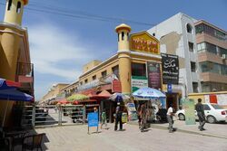
قاغـِلـِق Kargilik أو قارغلق Karghalik أو يىتشنگ Yecheng بالصينية، هي بلدة في شينجيانگ، بالصين. وتقع إلى الجنوب الشرقي من قشغر، على بعد 249 كم على الطريق وهي إلى الشمال من مزار بنحو 249 كم.[4] It is the seat of Kargilik (Yecheng) County.
Kargilik/Yecheng is the name of both the oasis and the town. It is situated on the southern rim of the Taklamakan desert, about halfway between Pishan and Yarkand on the southern route around the Tarim Basin. It is about 50 km north of Kokyar.[5] The rich loess terraces of the oasis are watered by the Tiznaf river and several smaller streams. They are joined to the north by a belt of cultivated land stretching about 40 km from the town of Yecheng to the Yarkand River.
التاريخ
During the Former Han period, this place was referred to as Xiye (Chinese: 西夜; Wade–Giles: Hsi-yeh). It was described as having 350 households, 4,000 people and 1,000 men able to bear arms.[6] It was ruled by a king of a neighboring area called Zihe (Chinese: 子合; Wade–Giles: Tzu-ho).[7] In the Later Han period it was also known as Piaosha which translates literally as "drifting sands".[8] It was noted for producing baicao (白草, literally "white grass") which gave a very poisonous substance used on arrow tips - probably from an aconite plant. Xiye is recorded in the Book of the Later Han as being distinct from Zihe and having 2,500 households, more than 10,000 people and 3,000 men able to bear arms.[9][10][8]
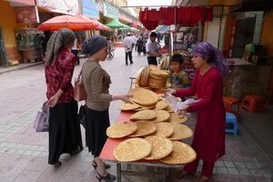
The Chinese pilgrim monk, Song Yun, passed through the Kingdom of Zhujuban (Chinese: 朱駒半) on his way from Khotan in 519 CE. He described it as being five days' journey around and that it produced much cereal, which was made into cakes. The inhabitants did not allow the slaughter of animals and only ate those which had died a natural death. Many of them lived in the mountains. They resembled the people of Khotan in their language and customs while their writing was like that of the Brahmans from India.[11]
Xuanzang, travelling through the country in 644 CE, described it as being very fertile, with abundant grapes, pears and plums. He said it was more than 1,000 li in circuit, with a capital city measuring more than 10 li around. The writing was like that of Khotan but the spoken language was different. Although he says the people were sincere Buddhists, they had little culture or education and he found them rude and deceitful. Many monasteries were in ruins and the 100 or so monks left were of the Mahayana school. He added that the Mahayana canonical texts were more numerous here than in any other country Buddhism had reached.
It apparently sent an embassy to China at the beginning of the Taiyan period (435-439 CE) and tribute was sent regularly after that. It later fell under the power of the Hephthalites and then the Western Turks. In 639 the ruler sent an embassy to the Chinese court and by 659 was included as part of the region called the "Four Garrisons" by the Chinese after their defeat of the Turkish chief, Duman.
The population were presumably converted to Islam soon after the new religion arrived in the Tarim Basin about 1006 CE.[citation needed]
During the 1800s, Kargalik contained many foreign slaves who had integrated into the Chinese state. After being freed, many slaves such as Gilgitis in Xinjiang cities like Tashkurgan, Yarkand and Karghallik, stayed rather than return Hunza in Gilgit. Most of these slaves were women who married local slaves and free men and had children with them. Sometimes the women were married to their masters, other slaves or free men who were not their masters. There were ten slave men to slave women married couples and 15 master-female slave couples, with several other non-master free men married to slave women. Both slaves and free Turki and Chinese men fathered children with Hunza slave women. A free man, Khas Muhammad, was married with two children to a female slave named Daulat, aged 24. A Gilgiti slave woman aged 26, Makhmal, was married to a Chinese slave man, Allah Vardi and had three children with him.[12]
In 1994, the Chinese character name for the town was set as Kageleke (喀格勒克镇).[3]
On 28 February 2012, ethnic Uyghurs, wielding knives, attacked a market in Yecheng, killing 13 people, mostly ethnic Han. The police shot seven attackers.[13]
الجغرافيا
Kargilik Town is located on the alluvial fan of the Tizinafu River located in the northern part of Kargilik County. Chasa Meschit Township (Qiasameiqite, Qiasimiqiti) surrounds Kargilik Town on the north, east and south. To the west, the town borders Yitimliqum Township (Yitimukong).[1]
التقسيمات الإدارية
As of 2019, Kargilik Town included fifty-two residential communities: (Mandarin Chinese pinyin-derived names)[14]
- Agezikangboyi (阿格孜康博依社区), Boxirekekuoqia (伯西热克阔恰社区), Bage'airekeboyi (巴格艾日克博依社区), Anjiangmaili (安江买里社区), Qipandai'erwazha (棋盘代尔瓦扎社区), Xicheng (西城社区), Bagemaili (巴格买里社区), Lanqiao (蓝桥社区), Linggongli (零公里社区), Xincheng (新城社区), Xingfunanlu (幸福南路社区), Yawage (亚瓦格社区), Hongqiao (虹桥社区), Xinshiji (新世纪社区), Jiefangbeilu (解放北路社区), Xingfuyuan (幸福苑社区), Langan (栏杆社区), Dongfanghong (东方红社区), Huochezhan (火车站社区), Yucailu (育才路社区), Youligunjiayi (尤里滚加依社区), Tugeman'airekeboyi (吐格曼艾热克博依社区), Kasike'aireke (卡斯克艾热克社区), Yabixi (亚比西社区), Tuguqikuoqia (吐古其阔恰社区), Gongyuan (公园社区), Wusitangboyi (乌斯塘博依社区), Hongqi (红旗社区), Tianyuan (田园社区), Jinguo (金果社区), Tuanjie (团结社区), Anakuoqia (阿那阔恰社区), Qiman (奇曼社区), Gongluhuayuan (公路花苑社区), Chahua (茶花社区), Qipandonglu (棋盘东路社区), Wuhaozha (五号闸社区), Yuecheng (越程社区), Kunlun (昆仑社区), Qingnianlu (青年路社区), Youyilu (友谊路社区), Shuangyonglu (双拥路社区), Alilu (阿里路社区), Aimin (爱民社区), Yusaisi (玉赛斯社区), Donghuanlu (东环路社区), Xueyu (雪域社区), Yuanlin (园林社区), Nanhuanlu (南环路社区), Huimin (惠民社区), Changhe (昌和社区), Jingguan (景观社区)
As of 2009:[15]
- Agezikangboyi 阿格孜康博依社区 Boxirekekuoqia 伯西热克阔恰社区 Bage'airikeboyi 巴格艾日克博依社区 Anjiangmaili 安江买里社区 Qipandai'erwazha 棋盘代尔瓦扎社区 Bageqia 巴格恰社区 Bagemaili 巴格买里社区 Lanqiao 蓝桥社区 Linggongli 零公里社区
الاقتصاد
In earlier times it was important as the usual starting-point for caravans to India, through the Pamirs, via Tashkurghan، أو عبر لداخ خلال ممرات قرة قرم.
Today there is a small town with a market, some shops and a bank. Large-scale irrigation has transformed huge areas of desert into productive agricultural land. Yecheng is the main centre for Chinese immigration into western Xinjiang and it has become quite a large, sprawling town.[4]
The total economic output of the town for that year of 2011 was valued at 309,812,200 CNY.[1]
الديمغرافيا
| Year | Pop. | ±% p.a. |
|---|---|---|
| 2000 | 59٬260 | — |
| 2010 | 75٬730 | +2.48% |
| [2] | ||
اعتبارا من 1997[تحديث], 78.7% of the residents of the town were Uyghur.[3]
النقل
Yecheng is served by China National Highways 219, 315[3] and the Kashgar-Hotan Railway.
المراجع
- ^ أ ب ت 喀格勒克镇简介. 叶城县人民政府网 (in الصينية المبسطة). 19 August 2015. Retrieved 14 April 2020.
喀格勒克镇的东部、南部和北部三面由恰斯米其提乡围绕,西与依提木孔乡接壤,辖区总面积37.5平方公里。
- ^ أ ب 叶城县历史沿革. XZQH.org (in الصينية المبسطة). 14 November 2010. Retrieved 31 January 2020.
2000年第五次人口普查,叶城县常住总人口370229人,其中:喀格勒克镇59260人{...}2010年第六次人口普查,叶城县常住总人口454328人,其中:喀格勒克镇75730人,
- ^ أ ب ت ث 1997年叶城县行政区划. XZQH.org (in الصينية المبسطة). 19 November 2010. Retrieved 31 January 2020.
喀格勒克镇 县政府驻地。清光绪十年( 1884)属消铁庄,清政府在此设置叶城底驿和洛河克亮噶尔军台。1958年属红旗公社,1970年析建城关公社,1994年改设喀格勒克镇。面积6平方千米,人口6.8万,其中维吾尔族占78.7%,{...}315国道过境。
- ^ أ ب Dorje (2009), p. 453.
- ^ Hill (2009), p. 196.
- ^ Hulsewé, A. F. P. and Loewe, M. A. N. 1979. China in Central Asia: The Early Stage 125 BC – AD 23: an annotated translation of chapters 61 and 96 of the History of the Former Han Dynasty, pp. 100-101. E. J. Brill, Leiden
- ^
 西夜國 on Wikisource
- ^ أ ب
 Fan Ye: 西夜國 on Wikisource
- ^ "Les pays d'Occident d’après le Heou Han chou." Édouard Chavannes. T'oung Pao 8, (1907) p. 174.
- ^ Hill, John E. 2003. "Annotated Translation of the Chapter on the Western Regions according to the Hou Hanshu." 2nd Draft Edition. [1]
- ^ Legge, James 1886. A Record of Buddhistic Kingdoms: Being an account by the Chinese Monk Fa-Hien of his travels in India and Ceylon (A.D. 399-414) in search of the Buddhist Books of Discipline, pp. lxxxviii-lxxxix. Oxford, Clarendon Press. Reprint: New York, Paragon Book Reprint Corp. 1965.
- ^ Raṇabīra Samāddāra (2002). Space, territory, and the state: new readings in international politics. Orient Blackswan. p. 83. ISBN 81-250-2209-0. Retrieved 2011-01-23.
- ^ "Deadly attack". Retrieved 18 June 2019.[dead link]
- ^ 2019年统计用区划代码和城乡划分代码:喀格勒克镇 (in الصينية المبسطة). National Bureau of Statistics of the People's Republic of China. 2019. Retrieved 14 April 2020.
统计用区划代码 城乡分类代码 名称 653126100001 121 阿格孜康博依社区 653126100002 121 伯西热克阔恰社区 653126100003 121 巴格艾日克博依社区 653126100004 121 安江买里社区 653126100005 122 棋盘代尔瓦扎社区 653126100006 121 西城社区 653126100007 121 巴格买里社区 653126100008 121 蓝桥社区 653126100009 121 零公里社区 653126100014 121 新城社区 653126100015 121 幸福南路社区 653126100016 121 亚瓦格社区 653126100017 121 虹桥社区 653126100018 121 新世纪社区 653126100019 121 解放北路社区 653126100020 121 幸福苑社区 653126100021 121 栏杆社区 653126100022 121 东方红社区 653126100023 121 火车站社区 653126100024 121 育才路社区 653126100025 121 尤里滚加依社区 653126100026 121 吐格曼艾热克博依社区 653126100027 121 卡斯克艾热克社区 653126100028 121 亚比西社区 653126100029 121 吐古其阔恰社区 653126100030 121 公园社区 653126100031 121 乌斯塘博依社区 653126100032 121 红旗社区 653126100033 121 田园社区 653126100034 121 金果社区 653126100035 121 团结社区 653126100036 121 阿那阔恰社区 653126100037 121 奇曼社区 653126100038 121 公路花苑社区 653126100039 121 茶花社区 653126100040 121 棋盘东路社区 653126100041 121 五号闸社区 653126100042 121 越程社区 653126100043 121 昆仑社区 653126100044 121 青年路社区 653126100045 121 友谊路社区 653126100046 121 双拥路社区 653126100047 121 阿里路社区 653126100048 121 爱民社区 653126100049 121 玉赛斯社区 653126100050 121 东环路社区 653126100051 121 雪域社区 653126100052 121 园林社区 653126100053 121 南环路社区 653126100054 121 惠民社区 653126100055 121 昌和社区 653126100056 121 景观社区
- ^ "2009年统计用区划代码和城乡划分代码".
المصادر
- Dorje, Gyurme (2009). Tibet Handbook. 4th Edition. Footprint, Bath, England. ISBN 978-1-906098-32-2.
- Hill, John E. 2004. The Peoples of the West from the Weilue 魏略 by Yu Huan 魚豢: A Third Century Chinese Account Composed between 239 and 265 CE. Draft annotated English translation. [2]
- Hill, John E. (2009) Through the Jade Gate to Rome: A Study of the Silk Routes during the Later Han Dynasty, 1st to 2nd Centuries CE. BookSurge, Charleston, South Carolina. ISBN 978-1-4392-2134-1.
- Hulsewé, A. F. P. and Loewe, M. A. N. 1979. China in Central Asia: The Early Stage 125 BC – AD 23: an annotated translation of chapters 61 and 96 of the History of the Former Han Dynasty. E. J. Brill, Leiden.
- Mallory, J. P. and Mair, Victor H. 2000. The Tarim Mummies: Ancient China and the Mystery of the Earliest Peoples from the West. Thames & Hudson. London. 2000.
- Stein, Aurel M. 1907. Ancient Khotan: Detailed report of archaeological explorations in Chinese Turkestan, 2 vols. Clarendon Press. Oxford. [3]
- Watters, Thomas 1904-1905. On Yuan Chwang’s Travels in India. London. Royal Asiatic Society. Reprint: Delhi. Mushiram Manoharlal. 1973.
وصلات خارجية
- Pages using gadget WikiMiniAtlas
- Articles containing صينية-language text
- CS1 uses الصينية-language script (zh)
- CS1 الصينية المبسطة-language sources (zh-hans)
- Articles with dead external links from June 2019
- Short description is different from Wikidata
- Articles containing Uyghur-language text
- Coordinates on Wikidata
- Articles containing Chinese-language text
- Articles with unsourced statements from April 2020
- مقالات فيها عبارات متقادمة منذ 1997
- جميع المقالات التي فيها عبارات متقادمة
- واحات الصين
- أماكن مأهولة على طريق الحرير
- أماكن مأهولة في شينجيانگ
- تقسيمات بمستوى بلديات في شينجيانگ
- مقار نواحي في شينجيانگ


