قسم تشونتالس
تشونتالس
Chontales | |
|---|---|
 | |
 | |
| البلد | |
| العاصمة | خويگالپا |
| المساحة | |
| • قسم | 6٬481 كم² (2٬502 ميل²) |
| التعداد (2021 estimate)[1] | |
| • قسم | 191٬856 |
| • الكثافة | 30/km2 (77/sq mi) |
| • Urban | 118٬625 |
| ISO 3166-2 | NI-CO |
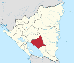
Chontales (إسپانية: Departamento de Chontales) (النطق الإسپاني: [tʃonˈtales]) is a department in Nicaragua. It covers an area of 6,481 km² and has a population of 191,856. The capital is Juigalpa. Some 90 kilometres (56 mi) of land overlooks Lake Cocibolca (Lake Nicaragua) on the western side. The department is livestock and fishing based, and is also a producer of apples.
Geography
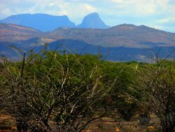
The Chontales Department is situated in the central-southwest part of the country. It is bordered by the Boaco Department to the north, the Río San Juan Department to the south, the South Caribbean Coast Autonomous Region to the east and Lake Cocibolca to the west. Chontales geographically primarily consists of the slopes around Lake Cocibolca, the Serranía Chontaleña range and rolling hills that undulate towards the Caribbean plain. The Cuisalá, a tributary of the Mayales flows in the northwestern part of the department. The shoreline of Lake Cocibolca within the department is about 90 kilometres (56 mi), between the mouths of the Tecolostote and Oyate rivers.[2]
Municipalities
The department is divided administratively into 10 municipalities:[2]
- Acoyapa
- Comalapa
- El Coral
- Juigalpa
- La Libertad
- San Francisco de Cuapa
- San Pedro de Lóvago
- Santo Domingo
- Santo Tomás
- Villa Sandino
Economy
The regional economy of Chontales is mainly based around livestock. The estates along the shore of the lake and along the road to Rama contain many plains and wet pastures to accommodate for cattle herds. The department is also a major producer of apples, producing over 743,000 apples according to one census, representing 8% of all agricultural land in Nicaragua.[2] Mining and fishing are also conducted in the department.[3]
Landmarks
The department contains the Arqueológico Gregorio Aguilar Barea, which has a number of indigenous artifacts attesting to the socio-cultural development of the people of Chontales throughout history. The Museo Comunitario Juigalpan María Ramos in Juigalpa reveals much about the history and identity of the region. The Reserva Natural de Amerrique is a nature reserve within the department, in a volcanic area.[3]
References
- ^ Citypopulation.de Population of departments in Nicaragua
- ^ أ ب ت "Caracteristicas del Departamento de Chontales". inide.gob.ni (in Spanish). CENAGRO. Retrieved 29 April 2020.
{{cite web}}: CS1 maint: unrecognized language (link) - ^ أ ب "Chontales". Visitnicaragua.com (in Spanish). Retrieved 29 April 2020.
{{cite web}}: CS1 maint: unrecognized language (link)
External links
- (in إسپانية) Political map of Chontales
- Pages using gadget WikiMiniAtlas
- Short description is different from Wikidata
- Articles with hatnote templates targeting a nonexistent page
- Pages using infobox settlement with no coordinates
- Articles containing إسپانية-language text
- Pages using Lang-xx templates
- Articles with إسپانية-language sources (es)
- Pages with empty portal template
- Coordinates on Wikidata
- Chontales Department
- Departments of Nicaragua
