وسط إيطاليا

Coordinates: 42°18′35″N 13°14′58″E / 42.3097°N 13.2494°E / 42.3097; 13.2494
(تم التحويل من Central Italy)
Central Italy
Italia centrale
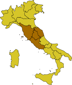
Map of Italy, highlighting Central Italy
CountryItaly
Regions
المساحة
 • الإجمالي58٬052 كم² (22٬414 ميل²)
التعداد
 • Estimate 
(2016 est.)
12٬067٬524
Languages 
 – Official languageItalian
 – Other common languages

Central Italy (إيطالية: Italia centrale or just Centro) is one of the five official statistical regions of Italy used by the National Institute of Statistics (ISTAT), a first-level NUTS region, and a European Parliament constituency.

. . . . . . . . . . . . . . . . . . . . . . . . . . . . . . . . . . . . . . . . . . . . . . . . . . . . . . . . . . . . . . . . . . . . . . . . . . . . . . . . . . . . . . . . . . . . . . . . . . . . . . . . . . . . . . . . . . . . . . . . . . . . . . . . . . . . . . . . . . . . . . . . . . . . . . . . . . . . . . . . . . . . . . . .

السكان

The resident population in central Italy amounts to 11,693,240 inhabitants.


المناطق

Regione Capoluogo Abitanti[2]
قالب:IT-LAZ Insigne Romanum coronatum.svg Roma 5٬707٬112
قالب:IT-MAR Ancona-Stemma.svg Ancona 1٬480٬839
قالب:IT-TOS FlorenceCoA.svg Firenze 3٬651٬152
قالب:IT-UMB Perugia-Stemma.svg Perugia 854٬137

The southernmost and easternmost parts of Lazio (Sora, Cassino, Gaeta, Cittaducale, Formia, and Amatrice districts) are often included in Southern Italy (the so-called Mezzogiorno) for cultural and historical reasons, since they were once part of the Kingdom of the Two Sicilies and southern Italian dialects are spoken.

As a geographical region, however, central Italy may also include the regions of Abruzzo and Molise,[3][4][5] which are otherwise considered part of Southern Italy for socio-cultural, linguistic and historical reasons.

أكبر البلديات تعداداً

Below is the list of the population residing in municipalities with more than 50,000 inhabitants.

# البلدية الصورة المنطقة المقاطعة التعداد[2]
1 Insigne Romanum coronatum.svg روما senza_cornice قالب:IT-LAZ قالب:IT-RM 2٬748٬109
2 FlorenceCoA.svg Firenze senza_cornice قالب:IT-TOS قالب:IT-FI 360٬930
3 Prato-Stemma.svg پراتو senza_cornice قالب:IT-TOS قالب:IT-PO 195٬736
4 Perugia-Stemma.svg Perugia senza_cornice قالب:IT-UMB قالب:IT-PG 161٬748
5 Livorno-Stemma.svg ليڤورنو senza_cornice قالب:IT-TOS قالب:IT-LI 152٬914
6 Latina-Stemma.svg Latina senza_cornice قالب:IT-LAZ قالب:IT-LT 127٬564
7 Terni-Stemma.svg Terni senza_cornice قالب:IT-UMB قالب:IT-TR 106٬370
8 Ancona-Stemma.svg Ancona senza_cornice قالب:IT-MAR قالب:IT-AN 98٬356
9 Arezzo-Stemma.svg Arezzo senza_cornice قالب:IT-TOS قالب:IT-AR 96٬260
10 Coat of arms of Pesaro.svg Pesaro senza_cornice قالب:IT-MAR قالب:IT-PU 95٬376
11 Coat of Arms of Pistoia.svg پيستويا senza_cornice قالب:IT-TOS قالب:IT-PT 89٬309
14 Guidonia Montecelio-Stemma.png Guidonia Montecelio senza_cornice قالب:IT-LAZ قالب:IT-RM 89٬114
13 Lucca-Stemma.svg لوكا senza_cornice قالب:IT-TOS قالب:IT-LU 88٬798
12 Pisa-Stemma.png پيزا senza_cornice قالب:IT-TOS قالب:IT-PI 88٬737
16 Fiumicino-Stemma.png فيوميتشينو senza_cornice قالب:IT-LAZ قالب:IT-RM 81٬426
15 Grosseto-Stemma.svg Grosseto senza_cornice قالب:IT-TOS قالب:IT-GR 81٬321
17 Aprilia-Stemma.png أپريليا senza_cornice قالب:IT-LAZ قالب:IT-LT 74٬126
18 Coat of arms of Massa.svg ماسا senza_cornice قالب:IT-TOS قالب:IT-MS 66٬160
19 Viterbo-Stemma.svg ڤيتربو senza_cornice قالب:IT-LAZ قالب:IT-VT 65٬949
20 Pomezia-Stemma.png Pomezia senza_cornice قالب:IT-LAZ قالب:IT-RM 64٬119
22 Coat of arms of Viareggio.svg Viareggio senza_cornice قالب:IT-TOS قالب:IT-LU 60٬579
21 Coat of arms of Carrara.svg Carrara senza_cornice قالب:IT-TOS قالب:IT-MS 59٬905
23 Fano-Stemma.svg فانو senza_cornice قالب:IT-MAR قالب:IT-PU 59٬785
26 Anzio-Stemma.png Anzio senza_cornice قالب:IT-LAZ قالب:IT-RM 58٬949
24 Foligno-Stemma.svg Foligno senza_cornice قالب:IT-UMB قالب:IT-PG 55٬226
25 Tivoli-Stemma.png تيڤولي senza_cornice قالب:IT-LAZ قالب:IT-RM 54٬916
27 Siena-Stemma.png سيينا senza_cornice قالب:IT-TOS قالب:IT-SI 52٬812
28 Velletri-Stemma it.png Velletri senza_cornice قالب:IT-LAZ قالب:IT-RM 52٬528
29 Civitavecchia-Stemma.svg Civitavecchia senza_cornice قالب:IT-LAZ قالب:IT-RM 51٬653


. . . . . . . . . . . . . . . . . . . . . . . . . . . . . . . . . . . . . . . . . . . . . . . . . . . . . . . . . . . . . . . . . . . . . . . . . . . . . . . . . . . . . . . . . . . . . . . . . . . . . . . . . . . . . . . . . . . . . . . . . . . . . . . . . . . . . . . . . . . . . . . . . . . . . . . . . . . . . . . . . . . . . . . .

المقاطعات

Provincia Regione
Provincia di Frosinone-Stemma.svg Provincia di Frosinone senza cornice

Lazio

Provincia di Latina-Stemma.svg Provincia di Latina
Coat of arms of the province of Rieti.svg Provincia di Rieti
Provincia di Roma-Stemma.svg Città metropolitana di Roma Capitale
Provincia di Viterbo-Stemma.svg Provincia di Viterbo
Provincia di Ancona-Stemma.svg مقاطعة أنكونا senza_cornice

Marche

Provincia di Ascoli Piceno-Stemma.png مقاطعة أسكولي پيتشنو
Provincia di Fermo-Stemma.svg مقاطعة فرمو
Provincia di Macerata-Stemma.svg Provincia di Macerata
Provincia di Pesaro e Urbino-Stemma.png Provincia di Pesaro e Urbino
senza cornice Provincia di Arezzo senza cornice

Toscana

senza cornice Città metropolitana di Firenze
senza cornice Provincia di Grosseto
senza cornice Provincia di Livorno
senza cornice Provincia di Lucca
senza cornice Provincia di Massa-Carrara
senza cornice Provincia di Pisa
senza cornice Provincia di Pistoia
senza cornice Provincia di Prato
senza cornice Provincia di Siena
senza cornice Provincia di Perugia

senza cornice

Umbria

senza cornice Provincia di Terni

Politics

Marches, Tuscany, and Umbria, together with Emilia-Romagna, are considered to be the most left-leaning regions in Italy, and together are also referred to as the "Red Belt".[6][7][8][9] Lazio, except for Rome, is more politically conservative, a trait which it shares with both Northern and Southern Italy.[بحاجة لمصدر]

Economy

The gross domestic product (GDP) of the region was 380.9 billion euros in 2018, accounting for 21.6% of Italy's economic output. The GDP per capita adjusted for purchasing power was 31,500 euros, or 105% of the EU27 average the same year.[10]

See also


. . . . . . . . . . . . . . . . . . . . . . . . . . . . . . . . . . . . . . . . . . . . . . . . . . . . . . . . . . . . . . . . . . . . . . . . . . . . . . . . . . . . . . . . . . . . . . . . . . . . . . . . . . . . . . . . . . . . . . . . . . . . . . . . . . . . . . . . . . . . . . . . . . . . . . . . . . . . . . . . . . . . . . . .

References

  1. ^ "Statistiche demografiche ISTAT". www.demo.istat.it. Archived from the original on 2017-11-27. Retrieved 2017-09-14.
  2. ^ أ ب خطأ استشهاد: وسم <ref> غير صحيح؛ لا نص تم توفيره للمراجع المسماة abitanti
  3. ^ Source: Touring Club Italiano (TCI), "Atlante stradale d'Italia". 1999–2000 TCI Atlas. ISBN 88-365-1115-5 (Northern Italy volume) – ISBN 88-365-1116-3 (Central Italy volume) – ISBN 88-365-1117-1 (Southern Italy volume)
  4. ^ Source: De Agostini, "Atlante Geografico Metodico". ISBN 88-415-6753-8
  5. ^ Source: Enciclopedia Italiana "Treccani"
  6. ^ "'Italians first': how the populist right became Italy's dominant force". The Guardian. 1 December 2018.
  7. ^ Roy Palmer Domenico (2002). The Regions of Italy: A Reference Guide to History and Culture. p. 313. ISBN 9780313307331.
  8. ^ "Italy's EU election results by region: Who won where?". The Local. 27 May 2019.
  9. ^ Publications, Europa Europa (2002). Western Europe 2003. p. 362. ISBN 9781857431520.
  10. ^ "Regional GDP per capita ranged from 30% to 263% of the EU average in 2018". Eurostat.

قالب:Expand Italian

42°18′35″N 13°14′58″E / 42.3097°N 13.2494°E / 42.3097; 13.2494