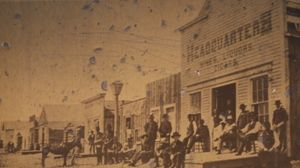
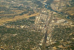
بلنگز، مونتانا
بلنگز
Billings | |
|---|---|
| مدينة بلنگز | |
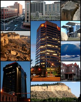 | |
| الكنية: "المدينة الساحرة" "مدينة السفوح" "نجمة بلد السماء الكبيرة" "Montana's Trailhead" | |
| الشعار: "Billings Pride, City Wide | |
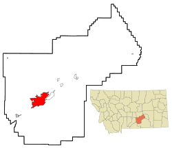 الموقع في مقاطعة يلوستون | |
| الإحداثيات: 45°47′01″N 108°30′22″W / 45.78361°N 108.50611°W | |
| Country | |
| الولاية | |
| المقاطعة | يلوستون |
| تأسست | 1877 |
| Incorporated | 1882 |
| السمِيْ | فردرك بلنگز |
| الحكومة | |
| • النوع | Mayor-Council |
| • Mayor | Bill Cole |
| • اداري المدينة | Chris Kukulski |
| • Governing body | City Council |
| المساحة | |
| • مدينة | 44٫72 ميل² (115٫83 كم²) |
| • البر | 44٫61 ميل² (115٫55 كم²) |
| • الماء | 0٫11 ميل² (0٫28 كم²) |
| المنسوب | 3٬123 ft (952 m) |
| التعداد | |
| • مدينة | 104٬170 |
| • Estimate (2019)[3] | 109٬577 |
| • الترتيب | US: 276th |
| • الكثافة | 2٬456٫11/sq mi (948٫30/km2) |
| • Urban | 114٬773 (US: 273th) |
| • العمرانية | 171٬677 (US: 245th) |
| منطقة التوقيت | UTC−7 (Mountain) |
| • الصيف (التوقيت الصيفي) | UTC−6 (Mountain) |
| ZIP codes | 59101-59117[4] |
| مفتاح الهاتف | 406 |
| FIPS code | 30-06550 |
| GNIS feature ID | 802034 |
| Highways | |
| الموقع الإلكتروني | CityofBillings.Net |
بلنگز Billings هي أكبر مدينة في ولاية مونتانا الأمريكية، بتعداد يُقدَّر بـ 109,577 في 2019.[5] Located in the south-central portion of the state, it is the seat of Yellowstone County and the principal city of the Billings Metropolitan Area, which had an estimated population of 180,385 in 2018.[6] It has a trade area of over 500,000.[7]
Billings was nicknamed the "Magic City" because of its rapid growth from its founding as a railroad town in March 1882. With one of the largest trade areas in the United States,[8] Billings is the trade and distribution center for much of Montana east of the Continental Divide, Northern Wyoming, and western portions of North Dakota and South Dakota. Billings is also the largest retail destination for much of the same area.
The city is experiencing rapid growth and a strong economy; it has had and is continuing to have the largest growth of any city in Montana. Parts of the metro area are seeing hyper growth. From 2000 to 2010 Lockwood, an eastern suburb, saw growth of 57.8%, the largest growth rate of any community in Montana.[9] Billings has avoided the economic downturn that affected most of the nation from 2008 to 2012 as well as the housing bust.[10][11] With more hotel accommodations than any area within a five-state region, the city hosts a variety of conventions, concerts, sporting events, and other rallies.[8] With the Bakken oil development in eastern Montana and western North Dakota, the largest oil discovery in U.S. history,[12][13] as well as the Heath shale oil discovery just north of Billings,[14] the city's growth rate stayed high during the shale oil boom.[15][16] Although the city is growing, its growth rate has diminished markedly with oil price declines in recent years.[17]
Area attractions include Pompey's Pillar, Pictograph Cave, Chief Plenty Coups State Park, Zoo Montana, and Yellowstone Art Museum. Within 100 miles are Little Bighorn Battlefield National Monument, Bighorn Canyon National Recreation Area, Red Lodge Mountain Resort, and the Beartooth Highway, which links Red Lodge to Yellowstone National Park.
الاسم
The city is named for Frederick H. Billings, a former president of the Northern Pacific Railroad. An earlier name for the area was Clark's Fork Bottom.
The Crow people, who are indigenous to the area, call the city Ammalapáshkuua. It means 'where they cut wood', and is named as such because of a sawmill built in the area by early white settlers.[18] The Cheyenne name is قالب:Lang-chy[19] and the Gros Ventre name is قالب:Lang-ats,[20] both also named for the sawmill, or translations of the Crow name.
التاريخ
قبل التاريخ
The downtown core and much of the rest of Billings is in the Yellowstone Valley, a canyon carved out by the Yellowstone River. Around 80 million years ago, the Billings area was on the shore of the Western Interior Seaway. The sea deposited sediment and sand around the shoreline. As the sea retreated, it left a deep layer of sand. Over millions of years, this sand was compressed into stone known as Eagle Sandstone. Over the last million years the river has carved its way down through this stone to form the canyon walls known as the Billings Rimrocks or the Rims.[21]
The Pictograph Caves are about five miles south of downtown. These caves contain over 100 pictographs (rock paintings), the oldest of which is over 2,000 years old. Approximately 30,000 artifacts (including stone tools and weapons) have been excavated from the site.[22] These excavations have proved the area has been occupied since at least 2600 BC until after 1800 AD.[23]
The Crow Indians have called the Billings area home since about 1700. The present-day Crow Nation is just south of Billings.[24]
تجريدة لويس وكلارك
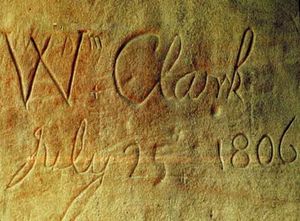
In July 1806, William Clark (of the Lewis and Clark Expedition) passed through the Billings area. On July 25 he arrived at what is now known as Pompeys Pillar and wrote in his journal "... at 4 P M arrived at a remarkable rock ... this rock I ascended and from its top had a most extensive view in every direction."[25] Clark carved his name and the date into the rock, leaving the only remaining physical evidence of their expedition. He named the place Pompy's Tower, naming it after the son of his Shoshone interpreter and guide Sacajawea. In 1965, Pompeys Pillar was designated as a national historic landmark, and was proclaimed a national monument in January 2001. An interpretive center has been built next to the monument.[26]
كولسون/بلنگز
The area where Billings is today was known as Clark's Fork Bottom. Clark's Fork Bottom was to be the hub for hauling freight to Judith and Musselshell Basins. At the time these were some of the most productive areas of the Montana Territory. The plan was to run freight up Alkali Creek, now part of Billings Heights, to the basins and Fort Benton on the Hi-Line.[بحاجة لمصدر]
الجغرافيا
المناخ
| Climate data for بلنگز، مونتانا (مطار بلنگز لوگن الدولي)، 1981–2010 normals | |||||||||||||
|---|---|---|---|---|---|---|---|---|---|---|---|---|---|
| Month | Jan | Feb | Mar | Apr | May | Jun | Jul | Aug | Sep | Oct | Nov | Dec | Year |
| Record high °F (°C) | 68 (20) |
72 (22) |
80 (27) |
90 (32) |
96 (36) |
105 (41) |
108 (42) |
105 (41) |
103 (39) |
91 (33) |
77 (25) |
73 (23) |
108 (42) |
| Mean maximum °F (°C) | 57.0 (13.9) |
61.3 (16.3) |
69.7 (20.9) |
79.4 (26.3) |
86.8 (30.4) |
95.3 (35.2) |
100.2 (37.9) |
98.3 (36.8) |
92.1 (33.4) |
81.2 (27.3) |
67.8 (19.9) |
56.0 (13.3) |
101.6 (38.7) |
| Mean daily maximum °F (°C) | 36.4 (2.4) |
40.2 (4.6) |
48.6 (9.2) |
57.6 (14.2) |
67.5 (19.7) |
77.2 (25.1) |
86.8 (30.4) |
85.7 (29.8) |
73.1 (22.8) |
59.4 (15.2) |
45.3 (7.4) |
35.2 (1.8) |
59.4 (15.2) |
| Daily mean °F (°C) | 27.1 (−2.7) |
30.4 (−0.9) |
37.7 (3.2) |
46.2 (7.9) |
55.6 (13.1) |
64.7 (18.2) |
72.8 (22.7) |
71.5 (21.9) |
60.3 (15.7) |
48.2 (9.0) |
35.8 (2.1) |
26.5 (−3.1) |
48.1 (8.9) |
| Mean daily minimum °F (°C) | 17.8 (−7.9) |
20.6 (−6.3) |
26.9 (−2.8) |
34.7 (1.5) |
43.6 (6.4) |
52.1 (11.2) |
58.8 (14.9) |
57.3 (14.1) |
47.5 (8.6) |
37.1 (2.8) |
26.3 (−3.2) |
17.8 (−7.9) |
36.7 (2.6) |
| Mean minimum °F (°C) | −6.7 (−21.5) |
−3.6 (−19.8) |
6.9 (−13.9) |
20.4 (−6.4) |
30.3 (−0.9) |
40.9 (4.9) |
49.5 (9.7) |
46.8 (8.2) |
33.4 (0.8) |
19.0 (−7.2) |
4.3 (−15.4) |
−6.1 (−21.2) |
−16.7 (−27.1) |
| Record low °F (°C) | −30 (−34) |
−38 (−39) |
−21 (−29) |
−5 (−21) |
14 (−10) |
32 (0) |
41 (5) |
35 (2) |
22 (−6) |
−7 (−22) |
−22 (−30) |
−32 (−36) |
−38 (−39) |
| Average precipitation inches (mm) | 0.48 (12) |
0.48 (12) |
1.06 (27) |
1.66 (42) |
2.18 (55) |
2.12 (54) |
1.32 (34) |
0.75 (19) |
1.30 (33) |
1.18 (30) |
0.63 (16) |
0.50 (13) |
13.66 (347) |
| Average snowfall inches (cm) | 8.4 (21) |
6.2 (16) |
10.2 (26) |
8.3 (21) |
2.0 (5.1) |
0.0 (0.0) |
0.0 (0.0) |
0.0 (0.0) |
1.1 (2.8) |
4.1 (10) |
6.5 (17) |
8.2 (21) |
55 (139.9) |
| Average precipitation days (≥ 0.01 in) | 6.2 | 6.2 | 9.2 | 10.2 | 12.0 | 11.5 | 7.9 | 6.0 | 7.1 | 7.3 | 6.3 | 6.6 | 96.5 |
| Average snowy days (≥ 0.1 in) | 6.1 | 5.9 | 6.9 | 4.5 | 0.9 | 0.0 | 0.0 | 0.0 | 0.5 | 2.4 | 4.6 | 6.9 | 38.7 |
| Average relative humidity (%) | 60.2 | 59.3 | 58.2 | 53.8 | 54.9 | 53.3 | 45.6 | 44.5 | 51.6 | 52.7 | 59.7 | 60.9 | 54.5 |
| Mean monthly sunshine hours | 130.2 | 156.6 | 236.5 | 255.5 | 282.0 | 304.7 | 355.4 | 329.0 | 255.8 | 203.2 | 127.6 | 116.4 | 2٬752٫9 |
| Percent possible sunshine | 46 | 54 | 64 | 63 | 61 | 65 | 75 | 75 | 68 | 60 | 45 | 43 | 62 |
| Source: NOAA (extremes 1934–present, sun and relative humidity 1961–1990)[27][28][29] | |||||||||||||
| Climate data for Billings, Montana (downtown), 1981–2010 normals | |||||||||||||
|---|---|---|---|---|---|---|---|---|---|---|---|---|---|
| Month | Jan | Feb | Mar | Apr | May | Jun | Jul | Aug | Sep | Oct | Nov | Dec | Year |
| Record high °F (°C) | 75 (24) |
76 (24) |
82 (28) |
92 (33) |
99 (37) |
108 (42) |
112 (44) |
107 (42) |
100 (38) |
95 (35) |
80 (27) |
75 (24) |
112 (44) |
| Mean daily maximum °F (°C) | 40.6 (4.8) |
45.2 (7.3) |
54.2 (12.3) |
63.0 (17.2) |
72.1 (22.3) |
80.6 (27.0) |
89.4 (31.9) |
88.7 (31.5) |
77.9 (25.5) |
64.5 (18.1) |
49.4 (9.7) |
39.2 (4.0) |
63.7 (17.6) |
| Daily mean °F (°C) | 28.1 (−2.2) |
32.0 (0.0) |
40.0 (4.4) |
48.5 (9.2) |
57.4 (14.1) |
65.8 (18.8) |
73.1 (22.8) |
71.7 (22.1) |
61.4 (16.3) |
49.7 (9.8) |
36.9 (2.7) |
27.3 (−2.6) |
49.3 (9.6) |
| Mean daily minimum °F (°C) | 15.6 (−9.1) |
18.8 (−7.3) |
25.7 (−3.5) |
33.9 (1.1) |
42.7 (5.9) |
51.0 (10.6) |
56.8 (13.8) |
54.6 (12.6) |
45.0 (7.2) |
34.8 (1.6) |
24.4 (−4.2) |
15.5 (−9.2) |
34.9 (1.6) |
| Record low °F (°C) | −39 (−39) |
−49 (−45) |
−34 (−37) |
−5 (−21) |
14 (−10) |
26 (−3) |
37 (3) |
28 (−2) |
18 (−8) |
−11 (−24) |
−28 (−33) |
−41 (−41) |
−49 (−45) |
| Average precipitation inches (mm) | 0.47 (12) |
0.47 (12) |
0.97 (25) |
1.65 (42) |
2.23 (57) |
2.28 (58) |
1.43 (36) |
0.79 (20) |
1.37 (35) |
1.38 (35) |
0.61 (15) |
0.53 (13) |
14.18 (360) |
| Average precipitation days (≥ 0.01 in) | 4.2 | 4.1 | 5.8 | 7.9 | 9.4 | 9.9 | 6.2 | 4.9 | 6.1 | 6.3 | 4.8 | 4.6 | 74.1 |
| Source: NOAA (extremes 1894–present)[27][30] | |||||||||||||
الديمغرافيا
| التعداد التاريخي | |||
|---|---|---|---|
| التعداد | Pop. | %± | |
| 1870 | 145 | — | |
| 1880 | 587 | 304٫8% | |
| 1890 | 836 | 42٫4% | |
| 1900 | 3٬211 | 284٫1% | |
| 1910 | 10٬031 | 212٫4% | |
| 1920 | 15٬100 | 50٫5% | |
| 1930 | 16٬386 | 8٫5% | |
| 1940 | 23٬216 | 41٫7% | |
| 1950 | 31٬834 | 37٫1% | |
| 1960 | 52٬851 | 66�0% | |
| 1970 | 61٬581 | 16٫5% | |
| 1980 | 66٬798 | 8٫5% | |
| 1990 | 81٬151 | 21٫5% | |
| 2000 | 89٬847 | 10٫7% | |
| 2010 | 104٬170 | 15٫9% | |
| 2019 (تق.) | 109٬577 | [3] | 5٫2% |
| U.S. Decennial Census[31] 2018 Estimate[5] | |||
السياسة والحكومة
| العمدة | Bill Cole |
| القسم 1 | Brent Cromley / Mike Yakawich |
| القسم 2 | Frank Ewalt / Roy Neese |
| القسم 3 | Denise Joy / Chris Friedel |
| القسم 4 | Reg Gibbs / Penny Ronning |
| القسم 5 | Dick Clark / Shaun Brown |
المدن الشقيقة
انظر أيضاً
- Not in Our Town – community-based effort to stop hate crimes in Billings in the mid-1990s
- The USS Billings (LCS-15), a Freedom، طراز littoral combat ship في البحرية الأمريكية، مسماة على اسم مدينة بلنگز.
الهامش
- ^ "2019 U.S. Gazetteer Files". United States Census Bureau. Retrieved July 26, 2020.
- ^ خطأ استشهاد: وسم
<ref>غير صحيح؛ لا نص تم توفيره للمراجع المسماةwwwcensusgov - ^ أ ب "Population and Housing Unit Estimates". United States Census Bureau. May 24, 2020. Retrieved May 27, 2020.
- ^ "ZIP Code Lookup". United States Postal Service. November 10, 2007. Archived from the original on September 3, 2007. Retrieved November 10, 2007.
- ^ أ ب "Population Estimates". United States Census Bureau. Retrieved May 25, 2019.
- ^ "Personal Income for Billings". US Bureau of Economic Analysis. Retrieved 2020-07-26.
- ^ "Best Places to Launch a Small Business 2009 – Billings, MT – FORTUNE Small Business". CNN. Retrieved 7 August 2012.
- ^ أ ب Big Sky Economic Development. "Big Sky Economic Development". Bigskyeda-edc.org. Retrieved 7 August 2012.
- ^ "Lockwood CDP QuickFacts from the US Census Bureau". Quickfacts.census.gov. Archived from the original on June 16, 2012. Retrieved August 7, 2012.
- ^ Lutey, Tom (December 19, 2010). "Billings economy not an illusion". Missoulian.com. Retrieved August 7, 2012.
- ^ "Eastern part of state faring better economically". BillingsGazette.com. December 26, 2010. Retrieved 7 August 2012.
- ^ "Bakken: The Biggest Oil Discovery in U.S. History". Marketwire.com. April 15, 2008. Retrieved 7 August 2012.
- ^ "Bakken: The Biggest Oil Discovery in U.S. History | wallstreet:online". Wallstreet-online.de. April 15, 2008. Retrieved 7 August 2012.
- ^ "A piece of the oil action". BillingsGazette.com. March 6, 2011. Retrieved August 7, 2012.
- ^ "Experts say Billings will benefit from energy boom". BillingsGazette.com. March 4, 2011. Retrieved August 7, 2012.
- ^ "N. Dakota Bakken Oil Deposit Would Free USA of Foreign Oil Dependence – 2012 Pole Shift Witness". 2012poleshift.wetpaint.com. Archived from the original on July 3, 2012. Retrieved 7 August 2012.
- ^ "Archived copy". Archived from the original on August 15, 2018. Retrieved March 15, 2018.
{{cite web}}: CS1 maint: archived copy as title (link) - ^ "Apsáalooke Place Names Database". Library @ Little Big Horn College. Retrieved 2020-03-19.
- ^ "Cheyenne placenames". Cheyenne Language. Retrieved 2020-03-19.
- ^ Cowell, A.; Taylor, A.; Brockie, T. (2016). "Gros Ventre ethnogeography and place names: A diachronic perspective". Anthropological Linguistics. 58 (2): 132–170. doi:10.1353/anl.2016.0025. S2CID 151520012.
- ^ "The Shores of an Ancient Sea..." (PDF). Montana Department of Transportation. Retrieved March 27, 2013.
- ^ "Pictograph Cave State Park". Montana Fish, Wildlife, and Parks. Retrieved February 26, 2013.
- ^ "Pictograph Cave". National Park Service. Archived from the original on September 5, 201. Retrieved February 26, 2013.
{{cite web}}:|archive-date=/|archive-url=timestamp mismatch; سبتمبر 5, 2012 suggested (help) - ^ "Archived copy". Archived from the original on January 31, 2013. Retrieved January 31, 2013.
{{cite web}}: CS1 maint: archived copy as title (link) - ^ Meriwether Lewis and William Clark. "The Journals of Lewis and Clark, 1804–1806". Project Gutenburg. Retrieved February 26, 2013.
- ^ "Pompeys Pillar National Monument". Bureau of Land Management. Archived from the original on March 16, 2013. Retrieved February 26, 2013.
- ^ أ ب "NOWData – NOAA Online Weather Data". National Oceanic and Atmospheric Administration. Retrieved February 19, 2015.
- ^ "MT Billings Logan INTL AP". National Oceanic and Atmospheric Administration. Retrieved February 19, 2015.
- ^ "WMO climate normals for Billings/Logan Int'L ARPT, MT 1961–1990". National Oceanic and Atmospheric Administration. Retrieved February 19, 2015.
- ^ "MT Billings WTP". National Oceanic and Atmospheric Administration. Retrieved February 19, 2015.
- ^ United States Census Bureau. "Census of Population and Housing". Retrieved May 31, 2014.
- ^ "أعضاء مجلس المدينة". The City of Billings, Montana. Retrieved September 12, 2010.
خطأ استشهاد: الوسم <ref> ذو الاسم "autogenerated2" المُعرّف في <references> غير مستخدم في النص السابق.
خطأ استشهاد: الوسم <ref> ذو الاسم "billingsgazette.com" المُعرّف في <references> غير مستخدم في النص السابق.
خطأ استشهاد: الوسم <ref> ذو الاسم "cbsnews1" المُعرّف في <references> غير مستخدم في النص السابق.
خطأ استشهاد: الوسم <ref> ذو الاسم "NCDC Billings Airport" المُعرّف في <references> غير مستخدم في النص السابق.
خطأ استشهاد: الوسم <ref> ذو الاسم "NCDC Downtown Billings" المُعرّف في <references> غير مستخدم في النص السابق.
خطأ استشهاد: الوسم <ref> ذو الاسم "emporis.com" المُعرّف في <references> غير مستخدم في النص السابق.
<ref> ذو الاسم "google1" المُعرّف في <references> غير مستخدم في النص السابق.للاستزادة
- Van West, Carroll. Images of Billings: A Photographic History (Billings: Western Heritage Press, 1990)
- Wright, Kathryn. Billings: The Magic City and How It Grew (Billings: K. H. Wright, 1978)
- An Illustrated History of the Yellowstone Valley, State of Montana (Spokane, Wash.: Western Historical Publishing Company, 1907)
وصلات خارجية
- City of Billings
- Billings Chamber of Commerce
- Billings Public Schools
- Billings Statistics
- Montana Convention and Visitors Bureau (Billings)
![]() Billings travel guide from Wikivoyage
Billings travel guide from Wikivoyage
قالب:Billings, Montana قالب:Yellowstone County, Montana
قالب:Montana Regions and Towns with Breweries قالب:Montana county seats
- Pages using gadget WikiMiniAtlas
- CS1 errors: archive-url
- Articles with hatnote templates targeting a nonexistent page
- Missing redirects
- Short description is different from Wikidata
- Pages using infobox settlement with possible motto list
- Coordinates on Wikidata
- Pages using infobox settlement with unknown parameters
- Articles containing Crow-language text
- Articles with unsourced statements from May 2014
- Pages using US Census population needing update
- بلنگز، مونتانا
- مدن مونتانا
- مدن مقاطعة يلوستون، مونتانا
- Billings metropolitan area
- County seats in Montana
- أماكن مأهولة تأسست في 1877
- تأسيسات 1877 في إقليم مونتانا
- Railway towns in Montana


