مقاطعة بيڤرهد، مونتانا
Beaverhead County | |
|---|---|
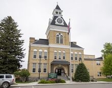
 Beaverhead County Courthouse | |
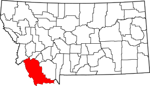
 الموقع ضمن ولاية Montana | |
 موقع Montana ضمن الولايات المتحدة | |
| الإحداثيات: 45°07′N 112°54′W / 45.12°N 112.90°W | |
| البلد | |
| State | |
| تأسست | 1865 |
| Seat | Dillon |
| Largest city | Dillon |
| المساحة | |
| • الإجمالي | 5٬572 ميل² (14٬430 كم²) |
| • البر | 5٬542 ميل² (14٬350 كم²) |
| • الماء | 30 ميل² (80 كم²) 0.5% |
| التعداد (2020) | |
| • الإجمالي | 9٬371 |
| • Estimate (2021) | 9٬524 ▲ |
| • الكثافة | 1٫7/sq mi (0٫65/km2) |
| منطقة التوقيت | UTC−7 (Mountain) |
| • الصيف (التوقيت الصيفي) | UTC−6 (MDT) |
| Congressional district | At-large |
| الموقع الإلكتروني | www |
| |
مقاطعة بيڤرهد إنگليزية: Beaverhead County هي إحدى مقاطعات ولاية مونتانا في الولايات المتحدة.
. . . . . . . . . . . . . . . . . . . . . . . . . . . . . . . . . . . . . . . . . . . . . . . . . . . . . . . . . . . . . . . . . . . . . . . . . . . . . . . . . . . . . . . . . . . . . . . . . . . . . . . . . . . . . . . . . . . . . . . . . . . . . . . . . . . . . . . . . . . . . . . . . . . . . . . . . . . . . . . . . . . . . . . .
التاريخ
The county name is derived from a rock formation, which the Shoshone described as being shaped like a beaver's head.[1]
The original county seat was the gold-mining town of Bannack. In 1881 it was moved to Dillon.
الجغرافيا
According to the United States Census Bureau, the county has a total area of 5,572 square miles (14,430 km2), of which 5,542 square miles (14,350 km2) is land and 30 square miles (78 km2) (0.3%) is water.[2] It is the largest county in Montana by area. Beaverhead impact structure is in the area. The Big Hole River (formerly called Wisdom River) runs through the county.
المقاطعات المجاورة
- Ravalli County - northwest
- Deer Lodge County - north
- Silver Bow County - north
- Madison County - east
- Fremont County, Idaho - southeast
- Clark County, Idaho - south
- Lemhi County, Idaho - west
Major highways
- Invalid type: I / Invalid type: US
- Invalid type: BL
- Invalid type: MT
- Invalid type: MT
- Invalid type: Sec
- Invalid type: Sec
National protected areas
السياسة
Beaverhead is a powerfully Republican county. It has not voted for a Democratic Presidential candidate since 1936.
| السنة | الجمهوري | الديمقراطي | حزب ثالث | |||
|---|---|---|---|---|---|---|
| رقم. | % | رقم. | % | رقم. | % | |
| 2020 | 3,923 | 69٫30% | 1,608 | 28٫40% | 130 | 2٫30% |
| 2016 | 3,353 | 69٫15% | 1,143 | 23٫57% | 353 | 7٫28% |
| 2012 | 3,289 | 68٫35% | 1,371 | 28٫49% | 152 | 3٫16% |
| 2008 | 3,008 | 63٫15% | 1,617 | 33٫95% | 138 | 2٫90% |
| 2004 | 3,067 | 72٫30% | 1,103 | 26�00% | 72 | 1٫70% |
| 2000 | 3,113 | 74٫19% | 799 | 19٫04% | 284 | 6٫77% |
| 1996 | 2,414 | 60٫06% | 1,164 | 28٫96% | 441 | 10٫97% |
| 1992 | 1,746 | 41٫97% | 1,098 | 26٫39% | 1,316 | 31٫63% |
| 1988 | 2,668 | 66٫73% | 1,274 | 31٫87% | 56 | 1٫40% |
| 1984 | 3,044 | 75٫44% | 942 | 23٫35% | 49 | 1٫21% |
| 1980 | 2,955 | 72٫02% | 842 | 20٫52% | 306 | 7٫46% |
| 1976 | 2,461 | 69٫46% | 1,013 | 28٫59% | 69 | 1٫95% |
| 1972 | 2,460 | 71٫99% | 775 | 22٫68% | 182 | 5٫33% |
| 1968 | 1,896 | 61٫04% | 853 | 27٫46% | 357 | 11٫49% |
| 1964 | 1,754 | 54٫29% | 1,469 | 45٫47% | 8 | 0٫25% |
| 1960 | 1,731 | 56٫88% | 1,307 | 42٫95% | 5 | 0٫16% |
| 1956 | 1,955 | 65٫52% | 1,029 | 34٫48% | 0 | 0�00% |
| 1952 | 2,196 | 70٫20% | 920 | 29٫41% | 12 | 0٫38% |
| 1948 | 1,583 | 52٫68% | 1,356 | 45٫12% | 66 | 2٫20% |
| 1944 | 1,556 | 54٫94% | 1,263 | 44٫60% | 13 | 0٫46% |
| 1940 | 1,725 | 51٫17% | 1,632 | 48٫41% | 14 | 0٫42% |
| 1936 | 1,304 | 36٫86% | 2,153 | 60٫85% | 81 | 2٫29% |
| 1932 | 1,418 | 43٫09% | 1,834 | 55٫73% | 39 | 1٫19% |
| 1928 | 1,906 | 62٫21% | 1,144 | 37٫34% | 14 | 0٫46% |
| 1924 | 1,386 | 50٫55% | 766 | 27٫94% | 590 | 21٫52% |
| 1920 | 2,049 | 68٫80% | 833 | 27٫97% | 96 | 3٫22% |
| 1916 | 1,455 | 48٫39% | 1,463 | 48٫65% | 89 | 2٫96% |
| 1912 | 708 | 38٫23% | 713 | 38٫50% | 431 | 23٫27% |
| 1908 | 878 | 51٫95% | 739 | 43٫73% | 73 | 4٫32% |
| 1904 | 1,021 | 59٫81% | 650 | 38٫08% | 36 | 2٫11% |
السكان
| التعداد التاريخي | |||
|---|---|---|---|
| التعداد | Pop. | %± | |
| 1870 | 722 | — | |
| 1880 | 2٬712 | 275٫6% | |
| 1890 | 4٬655 | 71٫6% | |
| 1900 | 5٬615 | 20٫6% | |
| 1910 | 6٬446 | 14٫8% | |
| 1920 | 7٬369 | 14٫3% | |
| 1930 | 6٬654 | −9٫7% | |
| 1940 | 6٬943 | 4٫3% | |
| 1950 | 6٬671 | −3٫9% | |
| 1960 | 7٬194 | 7٫8% | |
| 1970 | 8٬187 | 13٫8% | |
| 1980 | 8٬186 | 0�0% | |
| 1990 | 8٬424 | 2٫9% | |
| 2000 | 9٬202 | 9٫2% | |
| 2010 | 9٬246 | 0٫5% | |
| 2020 | 9٬371 | 1٫4% | |
| 2021 (تق.) | 9٬524 | [4] | 1٫6% |
| U.S. Decennial Census[5] 1790-1960[6] 1900-1990[7] 1990-2000[8] 2010-2020[9] | |||
. . . . . . . . . . . . . . . . . . . . . . . . . . . . . . . . . . . . . . . . . . . . . . . . . . . . . . . . . . . . . . . . . . . . . . . . . . . . . . . . . . . . . . . . . . . . . . . . . . . . . . . . . . . . . . . . . . . . . . . . . . . . . . . . . . . . . . . . . . . . . . . . . . . . . . . . . . . . . . . . . . . . . . . .
الاقتصاد
Beaverhead County is one of the largest cattle and hay producing areas of Montana. Barrett's Minerals, one of the world's largest talc mines, calls Beaverhead County home.[10] In 2009, Barrett Hospital and Healthcare was the largest private employer in the county.
انظر أيضاً
- List of lakes in Beaverhead County, Montana
- List of mountains in Beaverhead County, Montana
- National Register of Historic Places listings in Beaverhead County, Montana
المراجع
- ^ Merrill, Andrea; Judy Jacobson (1997). Montana almanac. Helena MT: Falcon Publishing. p. 6. ISBN 1-56044-493-2.
- ^ "2010 Census Gazetteer Files". US Census Bureau. August 22, 2012. Archived from the original on December 5, 2014. Retrieved November 27, 2014.
- ^ Leip, David. "Atlas of US Presidential Elections". uselectionatlas.org. Retrieved April 2, 2018.
- ^ "Annual Estimates of the Resident Population for Counties: April 1, 2020 to July 1, 2021". Retrieved June 26, 2022.
- ^ "U.S. Decennial Census". U.S. Census Bureau. Retrieved November 27, 2014.
- ^ "Historical Census Browser". University of Virginia Library. Retrieved November 27, 2014.
- ^ "Population of Counties by Decennial Census: 1900 to 1990". U.S. Census Bureau. Retrieved November 27, 2014.
- ^ "Census 2000 PHC-T-4. Ranking Tables for Counties: 1990 and 2000" (PDF). U.S. Census Bureau. Archived (PDF) from the original on 2010-03-27. Retrieved November 27, 2014.
- ^ خطأ استشهاد: وسم
<ref>غير صحيح؛ لا نص تم توفيره للمراجع المسماةQF - ^ State of Montana. "Beaverhead County" (PDF). Archived from the original (PDF) on September 6, 2011. Retrieved May 31, 2011.
وصلات خارجية

|
Deer Lodge County and Silver Bow County | Ravalli County | 
| |
| Madison County | Lemhi County, Idaho | |||
| Fremont County, Idaho | Clark County, Idaho |
- Pages using gadget WikiMiniAtlas
- Short description is different from Wikidata
- Coordinates on Wikidata
- مقاطعات Montana
- Pages using infobox U.S. county with unknown parameters
- Articles containing إنگليزية-language text
- Pages using Lang-xx templates
- Jct template errors
- مقاطعات ولاية مونتانا الأمريكية
- Beaverhead County, Montana
- 1865 establishments in Montana Territory
- Populated places established in 1865