پوِرتو فرانسيسكو دى أوريانا
پوِرتو فرانسيسكو دى أوريانا
Puerto Francisco de Orellana (إل كوكا) | |
|---|---|
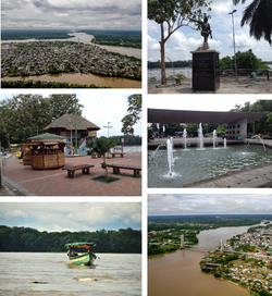
 From top, left to right: Panoramic view of the city, monument to Francisco de Orellana, Puerto Francisco de Orellana Boardwalk, Child's Park, canoe down the Napo River and Napo River Bridge. | |
| الإحداثيات: 00°27′45″S 76°59′03″W / 0.46250°S 76.98417°W[1] | |
| البلد | الإكوادور |
| المقاطعة | أوريانا |
| الكانتون | پوِرتو فرانسيسكو دى أوريانا |
| المساحة | |
| • المدينة | 146٫26 كم² (56٫47 ميل²) |
| المنسوب | 300 m (1٬000 ft) |
| التعداد (2010 census) | |
| • المدينة | 45٬163 |
| • الكثافة | 310/km2 (800/sq mi) |
| • العمرانية | 72٬795 |
| صفة المواطن | Orellanese |
| منطقة التوقيت | ECT |
| مفتاح الهاتف | (+593) 6 |
| Climate | Af |
| الموقع الإلكتروني | www.orellana.gob.ec (in إسپانية) |
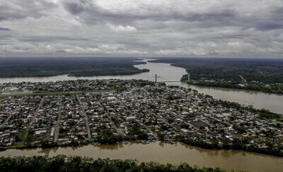
پوِرتو فرانسيسكو دى أوريانا ( Puerto Francisco de Orellana؛ النطق الإسپاني: [ˈpweɾto fɾanˈsisko ðe oɾeˈʝana])، وتُعرف أيضاً بإسم إل كوكا (El Coca ؛ النطق الإسپاني: [el ˈkoka])، هي عاصمة مقاطعة أوريانا في شرق الإكوادور. The city is located in the Amazon Rainforest at the confluence of the Coca River and the Napo River (the smaller Payamino River also merges into the Napo in the city). It has a population of 45,163 inhabitants as of 2010.[2] It is visited by tourists going into the Amazonian forest and is served by the Francisco de Orellana Airport.
. . . . . . . . . . . . . . . . . . . . . . . . . . . . . . . . . . . . . . . . . . . . . . . . . . . . . . . . . . . . . . . . . . . . . . . . . . . . . . . . . . . . . . . . . . . . . . . . . . . . . . . . . . . . . . . . . . . . . . . . . . . . . . . . . . . . . . . . . . . . . . . . . . . . . . . . . . . . . . . . . . . . . . . .
استعراض
The city is named for Francisco de Orellana, who explored the confluence of the Coca River and the Napo River. It is believed that he set sail from the current location of the town eventually making his way into the Amazon River seeing the "Amazon" or tribes in which the women also fought. Eventually Francisco de Orellana made it to the Atlantic. He made a second expedition leaving but died on the Amazon delta unable to find a way through.
الحكومة
The new mayor of the town was Antonio Vera in 2019 to replace Anita Rivas[3] who had served since 2005.
المناخ
تتسم پوِرتو فرانسيسكو دى أوريانا بـ tropical rainforest climate (Af) with heavy rainfall year-round.
| Climate data for پوِرتو فرانسيسكو دى أوريانا | |||||||||||||
|---|---|---|---|---|---|---|---|---|---|---|---|---|---|
| Month | Jan | Feb | Mar | Apr | May | Jun | Jul | Aug | Sep | Oct | Nov | Dec | Year |
| Mean daily maximum °C (°F) | 29.9 (85.8) |
30.0 (86.0) |
29.7 (85.5) |
29.3 (84.7) |
29.0 (84.2) |
28.6 (83.5) |
28.5 (83.3) |
29.6 (85.3) |
30.2 (86.4) |
30.4 (86.7) |
30.5 (86.9) |
30.5 (86.9) |
29.7 (85.4) |
| Daily mean °C (°F) | 24.8 (76.6) |
25.0 (77.0) |
24.9 (76.8) |
24.7 (76.5) |
24.4 (75.9) |
24.1 (75.4) |
24.0 (75.2) |
24.5 (76.1) |
25.0 (77.0) |
25.1 (77.2) |
25.4 (77.7) |
25.3 (77.5) |
24.8 (76.6) |
| Mean daily minimum °C (°F) | 19.8 (67.6) |
20.0 (68.0) |
20.1 (68.2) |
20.1 (68.2) |
19.9 (67.8) |
19.7 (67.5) |
19.5 (67.1) |
19.4 (66.9) |
19.8 (67.6) |
19.9 (67.8) |
20.3 (68.5) |
20.1 (68.2) |
19.9 (67.8) |
| Average rainfall mm (inches) | 243 (9.6) |
279 (11.0) |
235 (9.3) |
374 (14.7) |
329 (13.0) |
293 (11.5) |
241 (9.5) |
185 (7.3) |
252 (9.9) |
308 (12.1) |
309 (12.2) |
271 (10.7) |
3٬319 (130.8) |
| Source: Climate-Data.org[4] | |||||||||||||
المراجع
- ^ Puerto Francisco de Orellana, Orellana, Ecuador at GEOnet Names Server. Retrieved 7 November 2009.
- ^ citypopulation.de"[1]"
- ^ "Francisco de Orellana tiene nuevo alcalde - Periódico Independiente". web.archive.org. 2019-03-05. Archived from the original on 2019-03-05. Retrieved 2022-07-10.
- ^ "Climate: Puerto Francisco de Orellana". Climate-Data.org. Retrieved August 9, 2020.
وصلات خارجية
- Official website (in إسپانية)
- Official tourism website of El Coca (in إنگليزية)
 Media related to Puerto Francisco de Orellana at Wikimedia Commons


