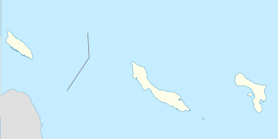
وحدة:Location map/data/Netherlands ABC islands (Lesser Antilles)
| الاسم | ABC islands (Lesser Antilles) | |||
|---|---|---|---|---|
| احداثيات الحدود | ||||
| 12.85 | ||||
| -70.1 | ←↕→ | -68.1 | ||
| 11.83 | ||||
| مركز الخريطة | 12°20′N 69°06′W / 12.34°N 69.1°W | |||
| الصورة | ABC Islands location map.svg | |||

| ||||
وحدة:Location map/data/Netherlands ABC islands (Lesser Antilles) is a location map definition used to overlay markers and labels on an equirectangular projection map of ABC islands (Lesser Antilles). The markers are placed by latitude and longitude coordinates on the default map or a similar map image.
Usage
These definitions are used by the following templates when invoked with parameter "Netherlands ABC islands (Lesser Antilles)":
{{Location map | Netherlands ABC islands (Lesser Antilles) | ...}}{{Location map many | Netherlands ABC islands (Lesser Antilles) | ...}}{{Location map+ | Netherlands ABC islands (Lesser Antilles) | ...}}{{Location map~ | Netherlands ABC islands (Lesser Antilles) | ...}}
Map definition
- name = ABC islands (Lesser Antilles)
- Name used in the default map caption
- image = ABC Islands location map.svg
- The default map image, without "Image:" or "File:"
- top = 12.85
- Latitude at top edge of map, in decimal degrees
- bottom = 11.83
- Latitude at bottom edge of map, in decimal degrees
- left = -70.1
- Longitude at left edge of map, in decimal degrees
- right = -68.1
- Longitude at right edge of map, in decimal degrees
Precision
Longitude: from West to East this map definition covers 2 degrees.
- At an image width of 200 pixels, that is 0.01 degrees per pixel.
- At an image width of 1000 pixels, that is 0.002 degrees per pixel.
Latitude: from North to South this map definition covers 1.02 degrees.
- At an image height of 200 pixels, that is 0.0051 degrees per pixel.
- At an image height of 1000 pixels, that is 0.001 degrees per pixel.
See also
- Location map templates
- Template:Location map, to display one mark and label using latitude and longitude
- Template:Location map many, to display up to nine marks and labels
- Template:Location map+, to display an unlimited number of marks and labels
- Infobox templates incorporating (passing values to) the Location map template
List
- Template:Infobox airport — alternative map support: relief (via pushpin_relief) and AlternativeMap (via pushpin_image)
- Template:Infobox ancient site — alternative map support: relief
- Template:Infobox artwork
- Template:Infobox building — alternative map support: relief
- Template:Infobox casino
- Template:Infobox castrum — alternative map support: relief (via map_relief)
- Template:Infobox cave (via Infobox map) — alternative map support: relief
- Template:Infobox cemetery
- Template:Infobox civil conflict
- Template:Infobox climbing route (via Infobox map) — alternative map support: relief
- Template:Infobox church — alternative map support: relief
- Template:Infobox concentration camp
- Template:Infobox dam — alternative map support: relief
- Template:Infobox dava
- Template:Infobox forest (via Infobox map) — alternative map support: relief
- Template:Infobox glacier (via Infobox map) — alternative map support: relief (displays relief image unless map_relief=0)
- Template:Infobox golf facility — alternative map support: relief
- Template:Infobox historic site — alternative map support: relief (via map_relief)
- Template:Infobox hospital — alternative map support: relief
- Template:Infobox hot spring (via Infobox map) — alternative map support: relief
- Template:Infobox hotel
- Template:Infobox hut — alternative map support: relief
- Template:Infobox lighthouse — alternative map support: relief
- Template:Infobox map (used by other infoboxes) — alternative map support: relief
- Template:Infobox military conflict — alternative map support: relief (via map_relief)
- Template:Infobox military conflict timeline
- Template:Infobox military installation — alternative map support: relief (via map_relief)
- Template:Infobox monastery
- Template:Infobox mountain (via Infobox map) — alternative map support: relief (displays relief image unless map_relief=0)
- Template:Infobox mountain pass (via Infobox map) — alternative map support: relief (displays relief image unless map_relief=0)
- Template:Infobox mountain range (via Infobox map) — alternative map support: relief (displays relief image unless map_relief=0)
- Template:Infobox museum — alternative map support: relief (via map_relief)
- Template:Infobox oil field — alternative map support: relief
- Template:Infobox oil refinery — alternative map support: relief
- Template:Infobox operational plan
- Template:Infobox park (via Infobox map) — alternative map support: relief
- Template:Infobox power station — alternative map support: relief
- Template:Infobox protected area (via Infobox map) — alternative map support: relief
- Template:Infobox reactor
- Template:Infobox religious building — alternative map support: relief
- Template:Infobox restaurant
- Template:Infobox settlement — alternative map support: relief (via pushpin_relief) and AlternativeMap (via pushpin_image)
- Template:Infobox temple
- Template:Infobox terrestrial impact site
- Template:Infobox valley (via Infobox map) — alternative map support: relief
- Template:Infobox waterfall (via Infobox map) — alternative map support: relief
- Template:Infobox World Heritage Site — alternative map support: relief