نايسار
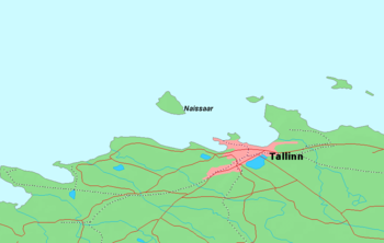
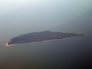
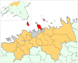
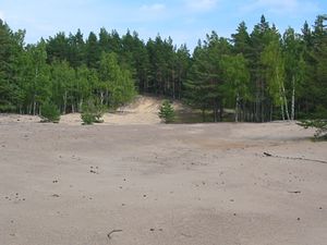
نايسار (Naissaar ؛ ألمانية: Nargen؛ سويدية: Nargö) هي جزيرة شمال غرب تالين (لكنها تتبع أسقفية ڤيمسي) في إستونيا. The island covers an area of 18.6 square kilometres (7.2 square miles). ويبلغ طولها 8 كم وعرضها 3.5 كم، وتقع على بعد 8.5 كم من البر الرئيسي. The highest point on the island is Kunilamägi, which is 27 metres (89 feet) above sea level. The island consists predominantly of coniferous forest and piles of stones and boulders. اعتبارا من 2005[تحديث], the island had a population of ten. Now the island has three dozen or so permanent residents and some summer residents. Administratively the island is divided into three villages: Lõunaküla (Storbyn), Tagaküla (Bakbyn) and Väikeheinamaa (Lillängin).
Until the Second World War, the island's population numbered about 450 people of Estonian-Swedish origin. However, these people fled during the war. Naissaar under Soviet rule was a military area and off-limits to the public.
Although the fortifications on the island date back to Peter the Great's scheme to fortify تالين, the main fortifications are from the period of Russian rule before World War II. Today, the previous small houses of the Swedish villages are being restored bit-by-bit. Also being restored is a narrow gauge railway that runs from the north to the southern tip of the island.
أحد أبرز مواطني الجزيرة كان برنارد شميت، عالم البصريات الألماني-الإستوني الذي اخترع تلسكوب شميت في 1930.
. . . . . . . . . . . . . . . . . . . . . . . . . . . . . . . . . . . . . . . . . . . . . . . . . . . . . . . . . . . . . . . . . . . . . . . . . . . . . . . . . . . . . . . . . . . . . . . . . . . . . . . . . . . . . . . . . . . . . . . . . . . . . . . . . . . . . . . . . . . . . . . . . . . . . . . . . . . . . . . . . . . . . . . .
الفنار
الجزيرة بـُني فيها فنار في 1788، ولكن الفنار الحالي يعود إلى 1960. ويبلغ ارتفاعه 47 متراً.
التاريخ
The island's name means "island of women". It is possible, therefore, that Naissaar is the island the chronicle of Adam of Bremen mentioned around 1075 under the name "Terra Feminarum". Estonian Swedish fishermen were well-established on the island by the 15th Century, and the Swedes erected a small fortress there in 1705 during the Great Northern War. After the war Estonia became part of the Russian Empire. The Tsar had a new fortress, with five bastions, built in 1720, for the defense of Tallinn and St. Petersburg.
An epic single-ship action took place off the north end of the island on قالب:OldStyleDateNY 1808 when the 14-gun Russian cutter Opyt put up an heroic though ultimately unsuccessful fight against the British 44-gun frigate إتشإمإس Salsette.
In 1850 the island's population was 155 people and by 1858 it had grown to 188, most of whom were Estonian Swedes. Between 1853 and 1856 the inhabitants built a new chapel that was part of the Swedish parish of St. Michael in Tallinn.
الحرب العالمية الأولى
Soviet Republic of Soldiers and Fortress-Builders of Naissaar Naissaare Nõukogude Vabariik | |||||||||
|---|---|---|---|---|---|---|---|---|---|
| 1917–1918 | |||||||||
 العلم | |||||||||
 The island of Naissaar close to the Estonian capital of Tallinn. | |||||||||
| المكانة | دولة غير معترف بها | ||||||||
| العاصمة | Obernargen (Söderby) | ||||||||
| اللغات الشائعة | Russian, Swedish, Estonian | ||||||||
| الحكومة | جمهورية سوڤيتية | ||||||||
| Chairman¹ | |||||||||
| الحقبة التاريخية | الحرب العالمية الأولى | ||||||||
• تأسست | ديسمبر 1917 | ||||||||
• انحلت | 26 فبراير 1918 | ||||||||
| Area | |||||||||
| 1918 | 18.56 km2 (7.17 sq mi) | ||||||||
| التعداد | |||||||||
• 1918 | 300 | ||||||||
| Currency | "Kerensky ruble" (Keriniki) | ||||||||
| |||||||||
¹ Chairman of the "Council of People's Commissars". | |||||||||
The Russians built a new fort during the First World War. Estonia acquired some autonomy in April 1917 by a decree of the Russian provisional government, though Estonia remained under the suzerainty of the Russian Empire. However, after the October Revolution the Bolshevik rebels suspended Estonia's provisional government, the Maapäev.
In December 1917, a group of Russian sailors commandeered Naissaar and proclaimed an independent "socialist republic", known as the Soviet Republic of Soldiers and Fortress-Builders of Nargen,[1] under the leadership of Stepan Petrichenko. The Russian sailors, numbering about 80–90 men, formed a government and levied taxes on the local population.[2]
At this point the new Estonian government appealed to the German army for assistance. The "republic" ceased to exist two months later, on February 26, 1918, when German forces occupied the island, causing the Russians to flee.[3] The sailors fled to Kronstadt, where Petrichenko came to play an important role in the Kronstadt uprising.
After the departure of the German troops the Estonian Provisional Government executed forty Bolshevik prisoners of war here in February 1919.[4] The island then became part of the new Estonian Republic in 1920.
الهامش
- ^ قالب:Et icon "Naissaare kroonika". Archived from the original on 2005-03-06. Retrieved 2007-10-24.: "nõukogu kuulutab saare soldatite ja kindluseehitajate sotsialistlikuks vabariigiks."
- ^ قالب:Et icon "Jalutuskäik saladusliku Naissaare lõunarajal". Eesti Loodus. Retrieved 2007-10-24.
- ^ قالب:Et icon "Naissaare kroonika". Archived from the original on 2005-03-06. Retrieved 2007-10-24.
- ^ Jackson, Battle of the Baltic, page 9
وصلات خارجية
- Pages using gadget WikiMiniAtlas
- Articles containing ألمانية-language text
- Pages using Lang-xx templates
- Articles containing سويدية-language text
- مقالات فيها عبارات متقادمة منذ 2005
- جميع المقالات التي فيها عبارات متقادمة
- Pages using infobox country with unknown parameters
- Coordinates on Wikidata
- جزر إستونية في البلطيق
- دول وأقاليم تأسست في 1917
- Kreis Harrien
- Viimsi Parish
- Tourist attractions in Harju County
- منارات إستونيا


