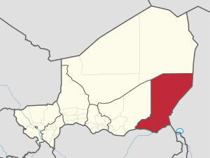
منطقة ديفا
Diffa | |
|---|---|
 Location within Niger | |
 Diffa Arrondissements | |
| الإحداثيات: 14°N 13°E / 14°N 13°E | |
| البلد | |
| Capital | Diffa |
| المساحة | |
| • الإجمالي | 156٬906 كم² (60٬582 ميل²) |
| التعداد (2012[1]) | |
| • الإجمالي | 593٬821 |
| • الكثافة | 3٫8/km2 (9٫8/sq mi) |
| منطقة التوقيت | UTC+1 (West Africa Time) |
| HDI (2017) | 0.336[2] low |
منطقة ديفا (Diffa Region) هي إحدى مناطق النيجر الثمانية، تقع في الجهة الجنوبية الشرقية من البلاد، وتحدها منطقة أغاديس من الشمال ونيجيريا من الجنوب وتشاد من الشرق ومنطقة زيندر من الغرب. عاصمتها مدينة ديفا. تصل مساحتها لحوالي 140 ألف كيلومترا مربعا.
التقسيمات الادارية
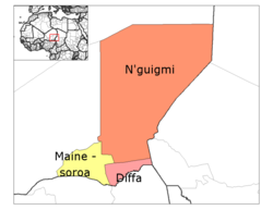
Diffa Region is divided into three Departments:
The Region also includes three Urban Communes, a number of Rural Communes, four Cantons, and over twenty Groupments (administrative councils of nomadic communities). The Urban Communes are Diffa, Maïné-Soroa, N'guigmi; while the Rural Communes include Bosso, Chétimari, Goudoumaria, N'gourti, Kabléwa, Nguel beyli, and Gueskérou.
الاقتصاد
The economy of Diffa Region is primarily agricultural, based upon pastoralism and farming. The major crop, grown both for subsistence and sale, is millet, especially drought-tolerant varieties. One third of arable land is devoted to farming: almost 105,000 hectares farmed of the 299,500 hectares of arable land. Areas of the east and south also grow rice and maize. Irrigation in the valleys around Maïné-Soroa make this possible, as does the edge of Lake Chad (3,000 km² in the far east) and the seasonal Komadougou Yobe river valley in the south, which forms around 150 km of the border with Nigeria. Despite this the Diffa Region is among the most unproductive agricultural areas in Niger, and all of West Africa, making it especially vulnerable to drought and famine.
انظر أيضاً
الهامش
- ^ Annuaire statistique du Niger
- ^ "Sub-national HDI - Area Database - Global Data Lab". hdi.globaldatalab.org (in الإنجليزية). Retrieved 2018-09-13.
- Portions of this article were translated from the French language Wikipedia article fr:Diffa (région), 2008-06-19.
- Decalo, Samuel (1997). Historical Dictionary of the Niger (3rd ed.). Boston & Folkestone: Scarecrow Press. ISBN 0-8108-3136-8.
- Geels, Jolijn (2006). Niger. Chalfont St Peter, Bucks / Guilford, Connecticut: Bradt UK / Globe Pequot Press. ISBN 978-1-84162-152-4.
- The Wodaabe Of Southeastern Niger. In Nikolaus Schareika. Ecological Knowledge And Herd Movement Strategies Among The Wodaabe Of Southeastern Niger. Institut für Ethnologie und Afrikastudien, Johannes Gutenberg-Universität Mainz/The Food and Agriculture Organization of the United Nations (2003) ISBN 92-5-105061-9
وصلات خارجية
