مقاطعة أوستن، تكساس
Austin County | |
|---|---|
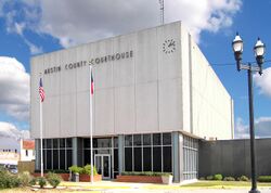
 The Austin County Courthouse in Bellville | |
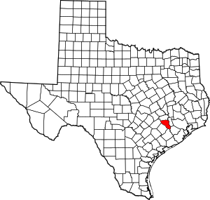
 الموقع ضمن ولاية Texas | |
 موقع Texas ضمن الولايات المتحدة | |
| الإحداثيات: 29°53′N 96°17′W / 29.88°N 96.28°W | |
| البلد | |
| State | |
| تأسست | 1837 |
| السمِيْ | ستيفن أوستن |
| Seat | Bellville |
| Largest city | Sealy |
| المساحة | |
| • الإجمالي | 656 ميل² (1٬700 كم²) |
| • البر | 647 ميل² (1٬680 كم²) |
| • الماء | 9٫9 ميل² (26 كم²) 1.5%% |
| التعداد (2010) | |
| • الإجمالي | 28٬417 |
| • الكثافة | 44/sq mi (17/km2) |
| منطقة التوقيت | UTC−6 (Central) |
| • الصيف (التوقيت الصيفي) | UTC−5 (CDT) |
| Congressional district | 10th |
| الموقع الإلكتروني | www |
مقاطعة أوستن إنگليزية: Austin County هي إحدى المقاطعات في ولاية تكساس، الولايات المتحدة. As of the 2010 census, the population was 28,417.[1] Its seat is Bellville.[2]
Austin County is included in the Houston-The Woodlands-Sugar Land, Texas Metropolitan Statistical Area.
Austin County is not to be confused with the city of Austin, the state capital city that lies in Travis County, about 110 miles to the northwest.
. . . . . . . . . . . . . . . . . . . . . . . . . . . . . . . . . . . . . . . . . . . . . . . . . . . . . . . . . . . . . . . . . . . . . . . . . . . . . . . . . . . . . . . . . . . . . . . . . . . . . . . . . . . . . . . . . . . . . . . . . . . . . . . . . . . . . . . . . . . . . . . . . . . . . . . . . . . . . . . . . . . . . . . .
التاريخ
Along with the rest of Texas, Austin County became:
- Part of an independent Mexico on September 27, 1821
- Part of Republic of Texas on March 2, 1836
- Part of United States of America on December 29, 1845
- Part of Confederate States of America on March 4, 1861
- Part of a state to acknowledge Union authority on June 19, 1865
In 1836, the Texas Legislature established Austin County, naming it for Stephen F. Austin, who facilitated Texas' Anglo-American colonization.
الجغرافيا
According to the U.S. Census Bureau, the county has a total area of 656 square miles (1,700 km2), of which 647 square miles (1,680 km2) is land and 9.9 square miles (26 km2) (1.5%) is covered by water.[3]
المقاطعات المجاورة
- Washington County (north)
- Waller County (east)
- Fort Bend County (southeast)
- Wharton County (south)
- Colorado County (west)
- Fayette County (northwest)
الديمغرافيا
| التعداد التاريخي | |||
|---|---|---|---|
| التعداد | Pop. | %± | |
| 1850 | 3٬841 | — | |
| 1860 | 10٬139 | 164�0% | |
| 1870 | 15٬087 | 48٫8% | |
| 1880 | 14٬429 | −4٫4% | |
| 1890 | 17٬859 | 23٫8% | |
| 1900 | 20٬676 | 15٫8% | |
| 1910 | 17٬699 | −14٫4% | |
| 1920 | 18٬874 | 6٫6% | |
| 1930 | 18٬860 | −0٫1% | |
| 1940 | 17٬384 | −7٫8% | |
| 1950 | 14٬663 | −15٫7% | |
| 1960 | 13٬777 | −6�0% | |
| 1970 | 13٬831 | 0٫4% | |
| 1980 | 17٬726 | 28٫2% | |
| 1990 | 19٬832 | 11٫9% | |
| 2000 | 23٬590 | 18٫9% | |
| 2010 | 28٬417 | 20٫5% | |
| 2020 (تق.) | 30٬167 | [4] | 6٫2% |
| U.S. Decennial Census[5] 1850–2010[6] 2010–2014[1] | |||
السياسة
الكونگرس الأمريكي
| السناتور | الاسم | الحزب | اِنتُخِب لأول مرة | Level | |
|---|---|---|---|---|---|
| مجلس الشيوخ | جون كرونين | جمهوري | 2002 | Senior Senator | |
| مجلس الشيوخ | تد كروز | جمهوري | 2012 | Junior Senator | |
| النواب | الاسم | الحزب | اِنتُخِب لأول مرة | Area(s) of Austin County represented | |
| District 10 | Michael McCaul | جمهوري | 2004 | المقاطعة بأجملها | |
| السنة | Republican | Democratic | Third parties |
|---|---|---|---|
| 2020 | 78.7% 11,447 | 20.3% 2,951 | 1.1% 156 |
| 2016 | 78.5% 9,637 | 18.9% 2,320 | 2.6% 317 |
| 2012 | 79.5% 9,265 | 19.3% 2,252 | 1.1% 132 |
| 2008 | 75.0% 8,786 | 24.1% 2,821 | 1.0% 114 |
| 2004 | 75.4% 8,072 | 24.1% 2,582 | 0.5% 48 |
| 2000 | 72.2% 6,661 | 26.1% 2,407 | 1.7% 159 |
| 1996 | 58.4% 4,669 | 34.0% 2,719 | 7.7% 613 |
| 1992 | 50.9% 4,015 | 28.9% 2,278 | 20.2% 1,597 |
| 1988 | 63.2% 4,524 | 36.2% 2,593 | 0.6% 43 |
| 1984 | 71.3% 4,872 | 28.4% 1,941 | 0.3% 21 |
| 1980 | 64.9% 3,734 | 32.9% 1,893 | 2.2% 126 |
| 1976 | 53.4% 2,686 | 46.0% 2,313 | 0.7% 34 |
| 1972 | 74.2% 3,084 | 25.1% 1,043 | 0.7% 27 |
| 1968 | 45.3% 1,971 | 29.8% 1,299 | 24.9% 1,084 |
| 1964 | 39.5% 1,545 | 60.4% 2,365 | 0.1% 5 |
| 1960 | 52.9% 1,978 | 46.2% 1,725 | 0.9% 35 |
| 1956 | 67.1% 2,501 | 32.6% 1,215 | 0.3% 10 |
| 1952 | 67.2% 2,964 | 32.7% 1,445 | 0.1% 4 |
| 1948 | 44.0% 1,260 | 43.7% 1,252 | 12.3% 353 |
| 1944 | 19.4% 619 | 41.3% 1,316 | 39.2% 1,249 |
| 1940 | 49.9% 1,400 | 50.0% 1,404 | 0.1% 3 |
| 1936 | 15.0% 290 | 84.8% 1,635 | 0.2% 4 |
| 1932 | 4.8% 142 | 95.0% 2,806 | 0.2% 7 |
| 1928 | 17.9% 466 | 82.0% 2,129 | 0.1% 2 |
| 1924 | 12.6% 457 | 71.7% 2,601 | 15.7% 569 |
| 1920 | 19.7% 568 | 18.6% 538 | 61.7% 1,784 |
| 1916 | 41.0% 673 | 58.4% 960 | 0.6% 10 |
| 1912 | 16.4% 244 | 78.2% 1,161 | 5.4% 80 |
. . . . . . . . . . . . . . . . . . . . . . . . . . . . . . . . . . . . . . . . . . . . . . . . . . . . . . . . . . . . . . . . . . . . . . . . . . . . . . . . . . . . . . . . . . . . . . . . . . . . . . . . . . . . . . . . . . . . . . . . . . . . . . . . . . . . . . . . . . . . . . . . . . . . . . . . . . . . . . . . . . . . . . . .
المجلس التشريعي لتكساس
مجلس شيوخ تكساس
District 18: Lois Kolkhorst (R) – first elected in 2014
Texas House of Representatives
District 13: Ben Leman (R) – first elected in 2018
Austin County Courthouse
County Judge: Tim Lapham (R)
Tax Assessor-Collector: Marcus A. Peña (R) – first elected in 2012
التعليم
The following school districts serve Austin County:
- Bellville Independent School District
- Brazos Independent School District (partial) (Formerly Wallis-Orchard ISD)
- Brenham Independent School District (partial)
- Columbus Independent School District (partial)
- Sealy Independent School District
- Burton Independent School District
(partial)
Blinn Junior College District is the designated community college for most of the county. Areas in Brazos ISD are in Wharton County Junior College District.[8]
النقل
الطرق الرئيسية
The TTC-69 component (recommended preferred) of the once-planned Trans-Texas Corridor went through Austin County.[9]
التجمعات
المدن
- Bellville (county seat)
- Brazos Country
- Sealy
- South Frydek
- Wallis
البلدات
Unincorporated communities
بلدة مهجورة
انظر أيضاً
- Adelsverein
- List of museums in the Texas Gulf Coast
- National Register of Historic Places listings in Austin County, Texas
- Recorded Texas Historic Landmarks in Austin County
المراجع
- ^ أ ب "State & County QuickFacts". United States Census Bureau. Archived from the original on July 6, 2011. Retrieved December 8, 2013.
- ^ "Find a County". National Association of Counties. Archived from the original on 2011-05-31. Retrieved 2011-06-07.
- ^ "2010 Census Gazetteer Files". United States Census Bureau. August 22, 2012. Retrieved April 18, 2015.
- ^ "Population and Housing Unit Estimates". United States Census Bureau. May 24, 2020. Retrieved May 27, 2020.
- ^ "U.S. Decennial Census". United States Census Bureau. Retrieved April 18, 2015.
- ^ "Texas Almanac: Population History of Counties from 1850–2010" (PDF). Texas Almanac. Retrieved April 18, 2015.
- ^ Leip, David. "Dave Leip's Atlas of U.S. Presidential Elections". uselectionatlas.org. Retrieved 2018-07-19.
- ^ Texas Education Code, Sec. 130.168. BLINN JUNIOR COLLEGE DISTRICT SERVICE AREA. Sec. 130.211. WHARTON COUNTY JUNIOR COLLEGE DISTRICT SERVICE AREA..
- ^ TxDoT, TTC Section C & S, Detailed Map 2, 2007-12-17 Archived فبراير 2, 2008 at the Wayback Machine
. . . . . . . . . . . . . . . . . . . . . . . . . . . . . . . . . . . . . . . . . . . . . . . . . . . . . . . . . . . . . . . . . . . . . . . . . . . . . . . . . . . . . . . . . . . . . . . . . . . . . . . . . . . . . . . . . . . . . . . . . . . . . . . . . . . . . . . . . . . . . . . . . . . . . . . . . . . . . . . . . . . . . . . .
وصلات خارجية
- Austin County website
- مقاطعة أوستن، تكساس from the Handbook of Texas Online
- Austin County from the Texas Almanac
- Austin County from the TXGenWeb Project
- Historic Austin County materials, hosted by the Portal to Texas History.

|
Washington County | Fayette County | 
| |
| Waller County | Colorado County | |||
| Fort Bend County | Wharton County |
- Pages using gadget WikiMiniAtlas
- Short description is different from Wikidata
- Coordinates on Wikidata
- مقاطعات Texas
- Articles containing إنگليزية-language text
- Pages using Lang-xx templates
- Pages using US Census population needing update
- مقاطعة أوستن، تكساس
- تأسيسات 1837 في جمهورية تكساس
- أماكن مأهولة تأسست في 1837
- هيوستن الكبرى
- مقاطعات تكساس
- مقاطعات ولاية تكساس الأمريكية

