مقاطعة آرتشر، تكساس
(تم التحويل من مقاطعة Archer، تكساس)
Archer County | |
|---|---|
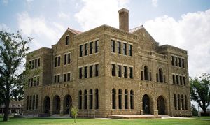
 The Archer County courthouse in Archer City. The Romanesque style structure was added to the National Register of Historic Places in 1977. | |
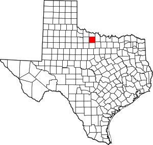
 الموقع ضمن ولاية Texas | |
 موقع Texas ضمن الولايات المتحدة | |
| الإحداثيات: 33°37′N 98°41′W / 33.61°N 98.69°W | |
| البلد | |
| State | |
| تأسست | 1858 |
| السمِيْ | Branch Tanner Archer, a commissioner for the Republic of Texas |
| Seat | Archer City |
| Largest city | Archer City |
| المساحة | |
| • الإجمالي | 926 ميل² (2٬398 كم²) |
| • البر | 910 ميل² (2٬356 كم²) |
| • الماء | 16 ميل² (42 كم²) 1.74%% |
| التعداد (2000) | |
| • الإجمالي | 8٬854 |
| • الكثافة | 9٫6/sq mi (3٫7/km2) |
| منطقة التوقيت | UTC−6 (Central) |
| • الصيف (التوقيت الصيفي) | UTC−5 (CDT) |
| الموقع الإلكتروني | www |
مقاطعة آرتشر إنگليزية: Archer County هي إحدى المقاطعات في ولاية تكساس، الولايات المتحدة الأمريكية.
. . . . . . . . . . . . . . . . . . . . . . . . . . . . . . . . . . . . . . . . . . . . . . . . . . . . . . . . . . . . . . . . . . . . . . . . . . . . . . . . . . . . . . . . . . . . . . . . . . . . . . . . . . . . . . . . . . . . . . . . . . . . . . . . . . . . . . . . . . . . . . . . . . . . . . . . . . . . . . . . . . . . . . . .
المصادر
وصلات خارجية=
- Archer County Home Page
- مقاطعة آرتشر، تكساس from the Handbook of Texas Online
- Historic Archer County materials, hosted by the Portal to Texas History.

|
Wichita County | 
| ||
| Clay County | Baylor County | |||
| Jack County | Young County |
الكلمات الدالة:
