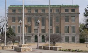
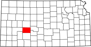
مقاطعة هودجمان، كانزس
Hodgeman County | |
|---|---|
 | |
 الموقع ضمن ولاية Kansas | |
 موقع Kansas ضمن الولايات المتحدة | |
| الإحداثيات: 38°05′N 99°54′W / 38.083°N 99.900°W | |
| البلد | |
| State | |
| تأسست | February 26, 1867 |
| السمِيْ | Amos Hodgman |
| Seat | Jetmore |
| Largest city | Jetmore |
| المساحة | |
| • الإجمالي | 860 ميل² (2٬200 كم²) |
| • البر | 860 ميل² (2٬200 كم²) |
| • الماء | 0٫3 ميل² (0٫8 كم²) 0.04%% |
| التعداد | |
| • Estimate (2018) | 1٬818 |
| • الكثافة | 2٫2/sq mi (0٫8/km2) |
| منطقة التوقيت | UTC−6 (Central) |
| • الصيف (التوقيت الصيفي) | UTC−5 (CDT) |
| Congressional district | 1st |
| الموقع الإلكتروني | hodgemancountyks.com |
مقاطعة هودجمان إنگليزية: Hodgeman County هي إحدى المقاطعات في ولاية كانزس، الولايات المتحدة.
. . . . . . . . . . . . . . . . . . . . . . . . . . . . . . . . . . . . . . . . . . . . . . . . . . . . . . . . . . . . . . . . . . . . . . . . . . . . . . . . . . . . . . . . . . . . . . . . . . . . . . . . . . . . . . . . . . . . . . . . . . . . . . . . . . . . . . . . . . . . . . . . . . . . . . . . . . . . . . . . . . . . . . . .
Government
Presidential elections
Hodgeman County is a Republican stronghold. Only six Republican presidential candidates have failed to win the county from 1888 to the present, and no Democrat has to managed to win even a quarter of the county's votes since Michael Dukakis in 1988. The last Democrat to carry the county was Jimmy Carter in 1976.
| Year | Republican | Democratic | Third Parties |
|---|---|---|---|
| 2016 | 84.1% 855 | 12.2% 124 | 3.7% 38 |
| 2012 | 81.9% 868 | 16.9% 179 | 1.2% 13 |
| 2008 | 78.9% 865 | 19.3% 211 | 1.8% 20 |
| 2004 | 80.6% 953 | 18.9% 223 | 0.6% 7 |
| 2000 | 76.8% 835 | 19.9% 217 | 3.3% 36 |
| 1996 | 69.4% 808 | 21.6% 251 | 9.0% 105 |
| 1992 | 50.9% 625 | 21.0% 258 | 28.2% 346 |
| 1988 | 60.4% 732 | 36.2% 439 | 3.4% 41 |
| 1984 | 74.2% 939 | 24.2% 306 | 1.7% 21 |
| 1980 | 66.2% 831 | 27.0% 339 | 6.8% 86 |
| 1976 | 43.8% 576 | 53.0% 697 | 3.2% 42 |
| 1972 | 68.4% 853 | 26.5% 331 | 5.1% 63 |
| 1968 | 59.2% 756 | 30.3% 387 | 10.5% 134 |
| 1964 | 42.3% 607 | 57.3% 821 | 0.4% 6 |
| 1960 | 61.5% 926 | 37.8% 570 | 0.7% 11 |
| 1956 | 71.6% 1,113 | 28.0% 435 | 0.4% 6 |
| 1952 | 76.4% 1,330 | 22.5% 392 | 1.0% 18 |
| 1948 | 60.8% 945 | 37.9% 590 | 1.3% 20 |
| 1944 | 66.3% 982 | 33.1% 490 | 0.6% 9 |
| 1940 | 60.9% 1,092 | 38.5% 690 | 0.7% 12 |
| 1936 | 40.1% 781 | 59.7% 1,162 | 0.2% 3 |
| 1932 | 45.6% 847 | 53.2% 988 | 1.3% 24 |
| 1928 | 67.6% 1,122 | 31.8% 528 | 0.7% 11 |
| 1924 | 60.7% 899 | 24.8% 367 | 14.6% 216 |
| 1920 | 73.3% 945 | 23.7% 306 | 3.0% 38 |
| 1916 | 37.5% 564 | 50.5% 761 | 12.0% 181 |
| 1912 | 17.2% 136 | 38.1% 302 | 44.7% 354[أ] |
| 1908 | 57.1% 411 | 40.3% 290 | 2.6% 19 |
| 1904 | 67.5% 449 | 28.9% 192 | 3.6% 24 |
| 1900 | 56.3% 323 | 42.7% 245 | 1.1% 6 |
| 1896 | 53.7% 262 | 45.9% 224 | 0.4% 2 |
| 1892 | 61.2% 363 | 38.8% 230 | |
| 1888 | 64.0% 563 | 25.0% 220 | 11.0% 97 |
Laws
Following amendment to the Kansas Constitution in 1986, the county remained an alcohol-free, or "dry", county until 2004, when voters approved the sale of alcoholic beverages by the individual drink with a 30% food sales requirement.[2]
Education
Unified school districts
Communities
Cities
Townships
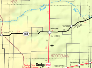
Hodgeman County is divided into nine townships. None of the cities within the county are considered governmentally independent, and all figures for the townships include those of the cities. In the following table, the population center is the largest city (or cities) included in that township's population total, if it is of a significant size.
| Township | FIPS | Population center |
Population | Population density /km2 (/sq mi) |
Land area km2 (sq mi) |
Water area km2 (sq mi) |
Water % | Geographic coordinates |
|---|---|---|---|---|---|---|---|---|
| Benton | 06225 | 48 | 1 (1) | 93 (36) | 0 (0) | 0.13% | 38°2′39″N 100°10′18″W / 38.04417°N 100.17167°W | |
| Center | 11725 | 1,121 | 3 (8) | 374 (144) | 0 (0) | 0.05% | 38°5′7″N 99°53′46″W / 38.08528°N 99.89611°W | |
| Hallet | 29525 | 62 | 0 (1) | 182 (70) | 0 (0) | 0% | 38°5′40″N 100°4′10″W / 38.09444°N 100.06944°W | |
| Marena | 44575 | 432 | 1 (3) | 373 (144) | 0 (0) | 0.05% | 38°9′52″N 99°41′19″W / 38.16444°N 99.68861°W | |
| North Roscoe | 51350 | 51 | 0 (0) | 276 (106) | 0 (0) | 0.05% | 38°10′29″N 100°7′14″W / 38.17472°N 100.12056°W | |
| Sawlog | 63225 | 93 | 0 (1) | 187 (72) | 0 (0) | 0.02% | 37°58′18″N 99°54′32″W / 37.97167°N 99.90889°W | |
| South Roscoe | 66900 | 76 | 0 (1) | 185 (71) | 0 (0) | 0.04% | 37°56′59″N 100°6′31″W / 37.94972°N 100.10861°W | |
| Sterling | 68175 | 144 | 0 (1) | 374 (144) | 0 (0) | 0.02% | 37°59′46″N 99°40′24″W / 37.99611°N 99.67333°W | |
| Valley | 72825 | 58 | 0 (1) | 185 (71) | 0 (0) | 0% | 38°12′41″N 99°51′47″W / 38.21139°N 99.86306°W | |
| Sources: "Census 2000 U.S. Gazetteer Files". U.S. Census Bureau, Geography Division. Archived from the original on 2002-08-02. | ||||||||
. . . . . . . . . . . . . . . . . . . . . . . . . . . . . . . . . . . . . . . . . . . . . . . . . . . . . . . . . . . . . . . . . . . . . . . . . . . . . . . . . . . . . . . . . . . . . . . . . . . . . . . . . . . . . . . . . . . . . . . . . . . . . . . . . . . . . . . . . . . . . . . . . . . . . . . . . . . . . . . . . . . . . . . .
In popular culture
At the beginning of the 1992 film Unforgiven, the protagonist William Munny, played by Clint Eastwood, is living in Hodgeman County and working as a pig farmer, while attempting to hide evidence of his violent past from all those around him.
See also
References
- ^ http://uselectionatlas.org/RESULTS
- ^ "Map of Wet and Dry Counties". Alcoholic Beverage Control, Kansas Department of Revenue. November 2006. Archived from the original on 2007-10-08. Retrieved 2007-12-26.
- Notes
- ^ This total comprises 319 votes (40.28 percent) for Progressive Theodore Roosevelt (who carried the county) and 35 votes (4.42 percent) for Socialist Eugene V. Debs.
Further reading
- Handbook of Hodgeman County, Kansas; C.S. Burch Publishing Co; 34 pages; 1887.
- Standard Atlas of Hodgeman County, Kansas; Geo. A. Ogle & Co; 56 pages; 1907.
External links
- County
- Maps
- Pages using gadget WikiMiniAtlas
- Short description is different from Wikidata
- Coordinates on Wikidata
- مقاطعات Kansas
- Articles containing إنگليزية-language text
- Pages using Lang-xx templates
- Pages with empty portal template
- Official website different in Wikidata and Wikipedia
- Hodgeman County, Kansas
- Kansas counties
- 1867 establishments in Kansas
- Populated places established in 1867
- مقاطعات ولاية كانزاس الأمريكية

