مقاطعة هارلان، كنتاكي
Harlan County | |
|---|---|
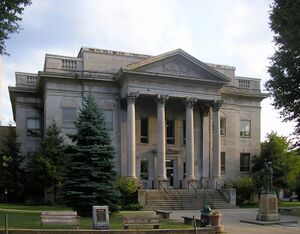
 Harlan County courthouse in Harlan | |
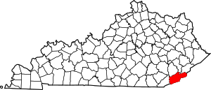
 الموقع ضمن ولاية Kentucky | |
 موقع Kentucky ضمن الولايات المتحدة | |
| الإحداثيات: 36°52′N 83°13′W / 36.86°N 83.22°W | |
| البلد | |
| State | |
| تأسست | 1819 |
| السمِيْ | Silas Harlan |
| Seat | Harlan |
| Largest city | Cumberland |
| المساحة | |
| • الإجمالي | 468 ميل² (1٬210 كم²) |
| • البر | 466 ميل² (1٬210 كم²) |
| • الماء | 2٫3 ميل² (6 كم²) 0.5%% |
| التعداد | |
| • Estimate (2018) | 26٬409 |
| • الكثافة | 63/sq mi (24/km2) |
| منطقة التوقيت | UTC−5 (Eastern) |
| • الصيف (التوقيت الصيفي) | UTC−4 (EDT) |
| Congressional district | 5th |
| الموقع الإلكتروني | judge-executive |
مقاطعة هارلان إنگليزية: Harlan County هي إحدى المقاطعات في ولاية كنتكي في الولايات المتحدة الأمريكية.
. . . . . . . . . . . . . . . . . . . . . . . . . . . . . . . . . . . . . . . . . . . . . . . . . . . . . . . . . . . . . . . . . . . . . . . . . . . . . . . . . . . . . . . . . . . . . . . . . . . . . . . . . . . . . . . . . . . . . . . . . . . . . . . . . . . . . . . . . . . . . . . . . . . . . . . . . . . . . . . . . . . . . . . .
الديمغرافيا
| التعداد التاريخي | |||
|---|---|---|---|
| التعداد | Pop. | %± | |
| 1820 | 1٬961 | — | |
| 1830 | 2٬929 | 49٫4% | |
| 1840 | 3٬015 | 2٫9% | |
| 1850 | 4٬268 | 41٫6% | |
| 1860 | 5٬494 | 28٫7% | |
| 1870 | 4٬415 | −19٫6% | |
| 1880 | 5٬278 | 19٫5% | |
| 1890 | 6٬197 | 17٫4% | |
| 1900 | 9٬838 | 58٫8% | |
| 1910 | 10٬566 | 7٫4% | |
| 1920 | 31٬546 | 198٫6% | |
| 1930 | 64٬557 | 104٫6% | |
| 1940 | 75٬275 | 16٫6% | |
| 1950 | 71٬751 | −4٫7% | |
| 1960 | 51٬107 | −28٫8% | |
| 1970 | 37٬370 | −26٫9% | |
| 1980 | 41٬889 | 12٫1% | |
| 1990 | 36٬574 | −12٫7% | |
| 2000 | 33٬202 | −9٫2% | |
| 2010 | 29٬278 | −11٫8% | |
| 2018 (تق.) | 26٬409 | [1] | −9٫8% |
| U.S. Decennial Census[2] 1790–1960[3] 1900–1990[4] 1990–2000[5] 2010–2013[6] | |||
نتائج الانتخابات الرئاسية
| Year | Republican | Democratic | Third parties |
|---|---|---|---|
| 2020 | 85.4% 9,367 | 13.6% 1,494 | 1.0% 110 |
| 2016 | 84.9% 9,129 | 12.8% 1,372 | 2.4% 256 |
| 2012 | 81.2% 8,652 | 17.2% 1,830 | 1.6% 175 |
| 2008 | 72.3% 7,165 | 26.1% 2,586 | 1.6% 163 |
| 2004 | 60.2% 6,659 | 39.1% 4,332 | 0.7% 79 |
| 2000 | 47.3% 4,980 | 50.9% 5,365 | 1.8% 190 |
| 1996 | 33.0% 3,337 | 58.0% 5,874 | 9.1% 916 |
| 1992 | 32.5% 3,970 | 55.7% 6,796 | 11.8% 1,437 |
| 1988 | 41.1% 5,166 | 58.4% 7,341 | 0.6% 69 |
| 1984 | 47.1% 6,959 | 51.9% 7,663 | 1.0% 140 |
| 1980 | 37.8% 5,460 | 60.9% 8,798 | 1.4% 199 |
| 1976 | 38.5% 4,624 | 60.8% 7,300 | 0.7% 82 |
| 1972 | 59.4% 6,527 | 39.6% 4,349 | 1.0% 109 |
| 1968 | 35.0% 4,572 | 48.9% 6,389 | 16.2% 2,116 |
| 1964 | 30.0% 4,025 | 70.0% 9,394 | 0.1% 9 |
| 1960 | 44.8% 7,485 | 55.2% 9,211 | 0.0% 0 |
| 1956 | 56.0% 8,820 | 43.9% 6,915 | 0.2% 26 |
| 1952 | 57.9% 10,025 | 42.0% 7,284 | 0.1% 21 |
| 1948 | 31.8% 4,402 | 66.1% 9,158 | 2.2% 300 |
| 1944 | 42.0% 5,815 | 57.8% 8,000 | 0.2% 23 |
| 1940 | 35.6% 5,859 | 64.2% 10,582 | 0.3% 42 |
| 1936 | 40.4% 7,510 | 59.6% 11,060 | 0.0% 0 |
| 1932 | 54.9% 11,118 | 44.9% 9,091 | 0.2% 45 |
| 1928 | 75.4% 12,251 | 24.4% 3,958 | 0.2% 37 |
| 1924 | 72.9% 9,634 | 16.2% 2,133 | 10.9% 1,441 |
| 1920 | 80.1% 7,493 | 19.3% 1,805 | 0.6% 53 |
| 1916 | 77.7% 2,670 | 20.1% 690 | 2.2% 75 |
| 1912 | 34.2% 612 | 19.3% 345 | 46.5% 831 |
انظر أيضاً
الهامش
- ^ "Population and Housing Unit Estimates". Retrieved July 29, 2019.
- ^ "U.S. Decennial Census". United States Census Bureau. Retrieved August 16, 2014.
- ^ "Historical Census Browser". University of Virginia Library. Retrieved August 16, 2014.
- ^ "Population of Counties by Decennial Census: 1900 to 1990". United States Census Bureau. Retrieved August 16, 2014.
- ^ "Census 2000 PHC-T-4. Ranking Tables for Counties: 1990 and 2000" (PDF). United States Census Bureau. Retrieved August 16, 2014.
- ^ خطأ استشهاد: وسم
<ref>غير صحيح؛ لا نص تم توفيره للمراجع المسماةQF - ^ Leip, David. "Dave Leip's Atlas of U.S. Presidential Elections". uselectionatlas.org. Retrieved April 7, 2018.
للاستزادة
- Portelli, Alessandro (2011). They Say in Harlan County: An Oral History. Oxford: Oxford University Press. ISBN 978-0-19-973568-6.
- Tom Hansell, Patricia Beaver and Angela Wiley, "Keep Your Eye upon the Scale," [1]
- G. C. Jones, "Growing up Hard in Harlan County," published by University Press of Kentucky, ISBN 978-0-8131-9080-8
وصلات خارجية
- Harlan County Clerk Office
- Harlan County Chamber of Commerce
- Black Mountain Rec Park – Harlan County's Tourism
- Harlan Daily Enterprise newspaper
- The Pine Mountain Settlement School
- The Kentucky Highlands Project
- Harlan County History and Genealogy
قالب:Harlan County, Kentucky قالب:Eastern Mountain Coal Fields (Kentucky)
تصنيفات:
- Pages using gadget WikiMiniAtlas
- Short description is different from Wikidata
- Coordinates on Wikidata
- مقاطعات Kentucky
- U.S. Counties with long url
- Articles containing إنگليزية-language text
- Pages using Lang-xx templates
- Pages using US Census population needing update
- مقاطعة هارلان، كنتكي
- مقاطعات أپالاشيا
- تأسيسات 1819 في كنتكي
- أماكن مأهولة تأسست في 1819
- مقاطعات كنتكي