مقاطعة هارت، كنتاكي
Hart County | |
|---|---|
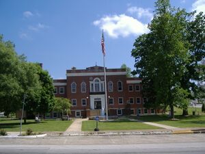
 Hart County Courthouse in Munfordville | |
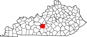
 الموقع ضمن ولاية Kentucky | |
 موقع Kentucky ضمن الولايات المتحدة | |
| الإحداثيات: 37°17′N 85°53′W / 37.29°N 85.89°W | |
| البلد | |
| State | |
| تأسست | 1819 |
| السمِيْ | نثانيال هارت |
| Seat | منفوردڤل |
| Largest city | هورس كيڤ |
| المساحة | |
| • الإجمالي | 418 ميل² (1٬080 كم²) |
| • البر | 412 ميل² (1٬070 كم²) |
| • الماء | 5٫8 ميل² (15 كم²) 1.4%% |
| التعداد | |
| • Estimate (2018) | 18٬906 |
| • الكثافة | 46/sq mi (18/km2) |
| منطقة التوقيت | UTC−6 (Central) |
| • الصيف (التوقيت الصيفي) | UTC−5 (CDT) |
| Congressional district | 2nd |
| الموقع الإلكتروني | www |
مقاطعة هارت إنگليزية: Hart County هي إحدى المقاطعات في ولاية كنتكي في الولايات المتحدة. وحسب تعداد 2010 بلغ عدد السكان 18,199 نسمة.[1] مقر المقاطعة هو منفوردڤل.[2] مقاطعة هارت هي مقاطعة جافة أي ممنوع بيع الكحول فيها.
. . . . . . . . . . . . . . . . . . . . . . . . . . . . . . . . . . . . . . . . . . . . . . . . . . . . . . . . . . . . . . . . . . . . . . . . . . . . . . . . . . . . . . . . . . . . . . . . . . . . . . . . . . . . . . . . . . . . . . . . . . . . . . . . . . . . . . . . . . . . . . . . . . . . . . . . . . . . . . . . . . . . . . . .
الجغرافيا
حسب مكتب تعداد الولايات المتحدة، تبلغ المساحة الإجمالية للمقاطعة 1,080 كم²، منهم 1,070 كم² هي أرض و 15 كم² (1.4%) مساحات مائية.[3]
الوحيش
في 2013، قتل صياد ذئبة في مقاطعة هارت، وكانت تلك هي أول ذئب رمادي يُرصَد في كنتكي في الأزمنة الحديثة.[4]
المقاطعات المجاورة
- مقاطعة هاردِن (الحد الشمالي الشرقي)
- LaRue County (الحد الشمالي الشرقي/الشرقي)
- مقاطعة گرين (الشرق)
- مقاطعة متكاف (جنوب شرق)
- مقاطعة بارِن (جنوب)
- مقاطعة إدمونسون (جنوب غرب)
- Grayson County (شمال غرب)
السمات الطبيعية
جزء من منتزه كهف الماموث الوطني والكهف سبب التسمية يوجد في غرب مقاطعة هارت.
نظام الكهوف فشر ردج يقع في مقاطعة هارت. وحتى سنة 2018، فقد رُسِمت خرائط لطول 201 كم منها وهي بذلك خامس أطول كهف في الولايات المتحدة وعاشر أطول كهف في العالم.[5][6]
الديمغرافيا
| التعداد التاريخي | |||
|---|---|---|---|
| التعداد | Pop. | %± | |
| 1820 | 4٬184 | — | |
| 1830 | 5٬191 | 24٫1% | |
| 1840 | 7٬031 | 35٫4% | |
| 1850 | 9٬093 | 29٫3% | |
| 1860 | 10٬348 | 13٫8% | |
| 1870 | 13٬687 | 32٫3% | |
| 1880 | 17٬133 | 25٫2% | |
| 1890 | 16٬439 | −4٫1% | |
| 1900 | 18٬390 | 11٫9% | |
| 1910 | 18٬173 | −1٫2% | |
| 1920 | 18٬544 | 2�0% | |
| 1930 | 16٬169 | −12٫8% | |
| 1940 | 17٬239 | 6٫6% | |
| 1950 | 15٬321 | −11٫1% | |
| 1960 | 14٬119 | −7٫8% | |
| 1970 | 13٬980 | −1�0% | |
| 1980 | 15٬402 | 10٫2% | |
| 1990 | 14٬890 | −3٫3% | |
| 2000 | 17٬445 | 17٫2% | |
| 2010 | 18٬199 | 4٫3% | |
| 2018 (تق.) | 18٬906 | 3٫9% | |
| التعداد العشري للولايات المتحدة[7] 1790-1960[8] 1900-1990[9] 1990-2000[10] 2010-2013[1] 2018[11] | |||
التجمعات
المدن
- Bonnieville
- Horse Cave
- Munfordville (county seat)
مكان مشهر بالتعداد
أماكن أخرى غير مشهرة
السياسة
الفدرالية
In the U.S House of Representatives, Hart County is represented by Brett Guthrie (R) of the second district.[12]
In presidential elections, Hart County was a swing county up until the 21st century. After that, they have shifted heavily towards the Republican Party. The last Democratic Party presidential candidate to carry the county was Bill Clinton in 1992.
| السنة | جمهوري | ديمقراطي | أحزاب ثالثة |
|---|---|---|---|
| 2020 | 75.8% 6,345 | 22.8% 1,908 | 1.4% 117 |
| 2016 | 73.2% 5,320 | 23.8% 1,730 | 3.0% 214 |
| 2012 | 64.3% 4,257 | 34.5% 2,283 | 1.2% 82 |
| 2008 | 64.5% 4,397 | 33.6% 2,290 | 1.9% 131 |
| 2004 | 62.9% 4,269 | 36.4% 2,470 | 0.7% 45 |
| 2000 | 61.9% 3,725 | 36.6% 2,201 | 1.6% 93 |
| 1996 | 46.9% 2,701 | 43.9% 2,527 | 9.2% 530 |
| 1992 | 41.0% 2,401 | 48.7% 2,852 | 10.3% 605 |
| 1988 | 53.5% 2,927 | 46.1% 2,519 | 0.4% 22 |
| 1984 | 57.1% 3,065 | 42.4% 2,278 | 0.5% 29 |
| 1980 | 50.4% 3,129 | 48.4% 3,005 | 1.1% 70 |
| 1976 | 38.4% 2,013 | 60.8% 3,189 | 0.8% 42 |
| 1972 | 60.3% 3,582 | 38.8% 2,307 | 0.8% 50 |
| 1968 | 51.4% 2,817 | 30.2% 1,658 | 18.4% 1,009 |
| 1964 | 37.0% 1,961 | 62.6% 3,313 | 0.4% 21 |
| 1960 | 53.6% 3,610 | 46.4% 3,129 | 0.0% 0 |
| 1956 | 50.4% 3,276 | 49.3% 3,207 | 0.4% 23 |
| 1952 | 49.7% 2,934 | 50.0% 2,952 | 0.3% 17 |
| 1948 | 46.9% 2,311 | 50.7% 2,495 | 2.4% 118 |
| 1944 | 48.9% 3,014 | 50.9% 3,138 | 0.2% 10 |
| 1940 | 46.6% 2,866 | 53.3% 3,280 | 0.2% 9 |
| 1936 | 48.3% 3,147 | 51.3% 3,341 | 0.4% 23 |
| 1932 | 39.2% 2,601 | 60.3% 4,008 | 0.5% 33 |
| 1928 | 59.7% 3,480 | 40.1% 2,339 | 0.2% 14 |
| 1924 | 48.1% 2,736 | 50.3% 2,862 | 1.6% 93 |
| 1920 | 51.7% 3,264 | 47.1% 2,972 | 1.2% 77 |
| 1916 | 49.1% 2,031 | 49.5% 2,048 | 1.4% 56 |
| 1912 | 16.0% 592 | 45.3% 1,674 | 38.7% 1,431 |
. . . . . . . . . . . . . . . . . . . . . . . . . . . . . . . . . . . . . . . . . . . . . . . . . . . . . . . . . . . . . . . . . . . . . . . . . . . . . . . . . . . . . . . . . . . . . . . . . . . . . . . . . . . . . . . . . . . . . . . . . . . . . . . . . . . . . . . . . . . . . . . . . . . . . . . . . . . . . . . . . . . . . . . .
الولاية
In the Kentucky State Senate, all of Hart county is located in the 5th district. It is represented by Stephen Meredith.[14]
In the Kentucky house of representatives all of Hart county is located in the 5th district. It is represented by Bart Rowland.[15]
انظر أيضاً
- مقاطعة جافة
- James Greene Hardy Local politician of the 1850s, was Lt. Gov. of Kentucky.
- National Register of Historic Places listings in Hart County, Kentucky
الهامش
- ^ أ ب "State & County QuickFacts". United States Census Bureau. Archived from the original on June 7, 2011. Retrieved March 8, 2014.
- ^ "Find a County". National Association of Counties. Retrieved 2011-06-07.
- ^ "2010 Census Gazetteer Files". United States Census Bureau. August 22, 2012. Archived from the original on August 12, 2014. Retrieved August 16, 2014.
- ^ Russ McSpadden (August 19, 2013). "Wild Wolf in Kentucky, First in 150 Years, Killed by Hunter". Earth First! News. Retrieved September 4, 2013.
- ^ Gulden, Bob (January 6, 2018). "USA Longest Caves". Retrieved 24 July 2018.
- ^ Gulden, Bob (January 7, 2018). "Worlds Longest Caves". Retrieved 24 July 2018.
- ^ "U.S. Decennial Census". United States Census Bureau. Retrieved August 16, 2014.
- ^ "Historical Census Browser". University of Virginia Library. Retrieved August 16, 2014.
- ^ "Population of Counties by Decennial Census: 1900 to 1990". United States Census Bureau. Retrieved August 16, 2014.
- ^ "Census 2000 PHC-T-4. Ranking Tables for Counties: 1990 and 2000" (PDF). United States Census Bureau. Retrieved August 16, 2014.
- ^ "QuickFacts. Hart County, Kentucky". United States Census Bureau. Retrieved July 26, 2019.
- ^ "Brett Guthrie". Brett Guthrie (in الإنجليزية الأمريكية). Retrieved 2019-07-02.
- ^ Leip, David. "Dave Leip's Atlas of U.S. Presidential Elections". uselectionatlas.org.
- ^ "Legislator-Profile - Legislative Research Commission". legislature.ky.gov. Retrieved 2019-07-25.
- ^ "Bart Rowland". Ballotpedia (in الإنجليزية). Retrieved 2019-07-02.
- Pages using gadget WikiMiniAtlas
- CS1 الإنجليزية الأمريكية-language sources (en-us)
- Short description is different from Wikidata
- Coordinates on Wikidata
- مقاطعات Kentucky
- Articles containing إنگليزية-language text
- Pages using Lang-xx templates
- Pages using US Census population needing update
- مقاطعة هارت، كنتكي
- تأسيسات 1819 في كنتكي
- أماكن مأهولة تأسست في 1819
- مقاطعات أپالاشيا
- مقاطعات كنتكي