مقاطعة لسلي، كنتكي
Leslie County | |
|---|---|
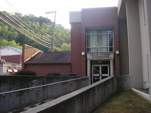
 Leslie County courthouse in Hyden | |
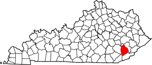
 الموقع ضمن ولاية Kentucky | |
 موقع Kentucky ضمن الولايات المتحدة | |
| الإحداثيات: 37°05′N 83°23′W / 37.09°N 83.38°W | |
| البلد | |
| State | |
| تأسست | 1878 |
| السمِيْ | پرستون لسلي |
| Seat | Hyden |
| Largest city | Hyden |
| المساحة | |
| • الإجمالي | 404 ميل² (1٬050 كم²) |
| • البر | 401 ميل² (1٬040 كم²) |
| • الماء | 3٫6 ميل² (9 كم²) 0.9%% |
| التعداد | |
| • Estimate (2018) | 10٬143 |
| • الكثافة | 28/sq mi (11/km2) |
| منطقة التوقيت | UTC−5 (Eastern) |
| • الصيف (التوقيت الصيفي) | UTC−4 (EDT) |
| Congressional district | 5th |
| الموقع الإلكتروني | www |
مقاطعة لسلي إنگليزية: Leslie County هي إحدى المقاطعات في ولاية كنتكي في الولايات المتحدة. وحسب تعداد 2010، فإن عدد سكان المقاطعة كان 11,310 نسمة.[1] عاصمة المقاطعة هي هايدن، كنتكي.[2] لزلي هي مقاطعة جافة أي محظور بيع الكحول فيها.
. . . . . . . . . . . . . . . . . . . . . . . . . . . . . . . . . . . . . . . . . . . . . . . . . . . . . . . . . . . . . . . . . . . . . . . . . . . . . . . . . . . . . . . . . . . . . . . . . . . . . . . . . . . . . . . . . . . . . . . . . . . . . . . . . . . . . . . . . . . . . . . . . . . . . . . . . . . . . . . . . . . . . . . .
تاريخ
مقاطعة لسلي تأسست في 1878. وقد أخذت اسمها من پرستون لسلي، حاكم كنتكي (1871-1875).[3]
The Hurricane Creek mine disaster in a Leslie County coal mine in 1970 killed 38 people.[4]
After resigning the presidency, Richard Nixon made his first public appearance at the Leslie County dedication of a recreation facility named for him. County Judge-Executive C. Allen Muncy claimed the Nixon invitation prompted the U.S. Department of Justice to obtain indictments of him and his associates on vote-fraud charges; while on appeal for his conviction, he won renomination in the Republican primary but lost the 1981 general election to independent Kermit Keen.[5]
الجغرافيا
المقاطعات المجاورة
- Perry County (شمال شرق)
- Harlan County (جنوب شرق)
- Bell County (جنوب غرب)
- Clay County (غرب)
الديمغرافيا
| التعداد التاريخي | |||
|---|---|---|---|
| التعداد | Pop. | %± | |
| 1880 | 3٬740 | — | |
| 1890 | 3٬964 | 6�0% | |
| 1900 | 6٬753 | 70٫4% | |
| 1910 | 8٬976 | 32٫9% | |
| 1920 | 10٬097 | 12٫5% | |
| 1930 | 10٬765 | 6٫6% | |
| 1940 | 14٬981 | 39٫2% | |
| 1950 | 15٬537 | 3٫7% | |
| 1960 | 10٬941 | −29٫6% | |
| 1970 | 11٬623 | 6٫2% | |
| 1980 | 14٬882 | 28�0% | |
| 1990 | 13٬642 | −8٫3% | |
| 2000 | 12٬401 | −9٫1% | |
| 2010 | 11٬310 | −8٫8% | |
| 2018 (تق.) | 10٬143 | [6] | −10٫3% |
| U.S. Decennial Census[7] 1790-1960[8] 1900-1990[9] 1990-2000[10] 2010-2013[1] | |||
الاقتصاد
شركات الفحم في مقاطعة لزلي
Communities
| Year | Republican | Democratic | Third parties |
|---|---|---|---|
| 2016 | 89.4% 4,015 | 8.9% 400 | 1.7% 77 |
| 2012 | 89.6% 4,439 | 8.7% 433 | 1.6% 81 |
| 2008 | 81.3% 3,574 | 17.4% 766 | 1.3% 57 |
| 2004 | 73.8% 3,661 | 25.5% 1,266 | 0.8% 37 |
| 2000 | 71.2% 3,159 | 27.3% 1,210 | 1.5% 65 |
| 1996 | 56.1% 2,296 | 35.8% 1,466 | 8.0% 328 |
| 1992 | 58.3% 2,879 | 32.2% 1,591 | 9.4% 466 |
| 1988 | 74.4% 3,280 | 25.1% 1,105 | 0.5% 24 |
| 1984 | 75.6% 3,385 | 24.0% 1,075 | 0.3% 15 |
| 1980 | 71.9% 3,536 | 27.0% 1,327 | 1.2% 58 |
| 1976 | 71.5% 3,770 | 28.0% 1,478 | 0.4% 23 |
| 1972 | 77.9% 3,299 | 21.6% 913 | 0.6% 24 |
| 1968 | 71.1% 2,615 | 22.5% 828 | 6.4% 236 |
| 1964 | 52.2% 1,971 | 47.6% 1,795 | 0.2% 8 |
| 1960 | 83.1% 3,894 | 17.0% 795 | |
| 1956 | 87.4% 3,770 | 12.3% 531 | 0.3% 14 |
| 1952 | 81.8% 3,239 | 17.8% 705 | 0.4% 15 |
| 1948 | 73.9% 2,397 | 24.2% 783 | 1.9% 62 |
| 1944 | 84.3% 2,679 | 15.7% 499 | 0.0% 0 |
| 1940 | 84.0% 3,292 | 16.0% 626 | 0.1% 3 |
| 1936 | 81.4% 2,716 | 18.5% 618 | 0.1% 3 |
| 1932 | 83.0% 2,810 | 16.8% 569 | 0.2% 8 |
| 1928 | 94.5% 2,806 | 5.4% 159 | 0.2% 6 |
| 1924 | 88.9% 2,052 | 9.7% 223 | 1.4% 33 |
| 1920 | 94.2% 2,576 | 5.2% 142 | 0.6% 16 |
| 1916 | 91.6% 1,516 | 8.0% 133 | 0.4% 6 |
| 1912 | 53.0% 606 | 9.2% 105 | 37.8% 433 |
. . . . . . . . . . . . . . . . . . . . . . . . . . . . . . . . . . . . . . . . . . . . . . . . . . . . . . . . . . . . . . . . . . . . . . . . . . . . . . . . . . . . . . . . . . . . . . . . . . . . . . . . . . . . . . . . . . . . . . . . . . . . . . . . . . . . . . . . . . . . . . . . . . . . . . . . . . . . . . . . . . . . . . . .
See also
References
- ^ أ ب "State & County QuickFacts". United States Census Bureau. Archived from the original on June 7, 2011. Retrieved March 6, 2014.
- ^ "Find a County". National Association of Counties. Archived from the original on May 31, 2011. Retrieved 2011-06-07.
- ^ The Register of the Kentucky State Historical Society, Volume 1. Kentucky State Historical Society. 1903. p. 36.
- ^ http://www.kyenc.org/entry/l/LESLI02.html
- ^ "The Big Lever," Appalshop Inc., 1982
- ^ "Population and Housing Unit Estimates". Retrieved July 29, 2019.
- ^ "U.S. Decennial Census". United States Census Bureau. Archived from the original on April 26, 2015. Retrieved August 17, 2014.
- ^ "Historical Census Browser". University of Virginia Library. Retrieved August 17, 2014.
- ^ "Population of Counties by Decennial Census: 1900 to 1990". United States Census Bureau. Retrieved August 17, 2014.
- ^ "Census 2000 PHC-T-4. Ranking Tables for Counties: 1990 and 2000" (PDF). United States Census Bureau. Retrieved August 17, 2014.
- ^ James River Coal Company – Blue Diamond complex
- ^ James River Coal Company – Bledsoe complex
- ^ Leip, David. "Dave Leip's Atlas of U.S. Presidential Elections". uselectionatlas.org. Retrieved 2018-07-03.
Notes
وصلات خارجية
- The Kentucky Highlands Project
- LeslieCounty.Net - oldest and largest site dealing with Leslie County
قالب:Leslie County, Kentucky قالب:Eastern Mountain Coal Fields (Kentucky)
- Pages using gadget WikiMiniAtlas
- Short description is different from Wikidata
- Coordinates on Wikidata
- مقاطعات Kentucky
- Articles containing إنگليزية-language text
- Pages using Lang-xx templates
- Pages using US Census population needing update
- Pages with empty portal template
- مقاطعة لسلي، كنتكي
- مقاطعات أپالاشيا
- تأسيسات 1878 في كنتكي
- أماكن مأهولة تأسست في 1878
- مقاطعات كنتكي