مقاطعة كستر، أيداهو
Custer County | |
|---|---|
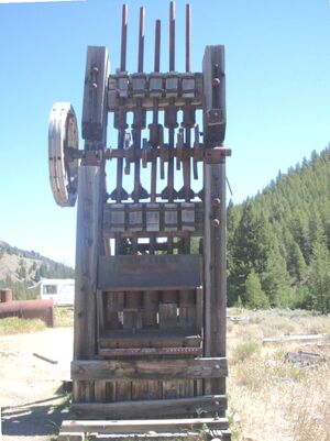 Mill used to process gold and silver ore at Yankee Fork mining operations. | |
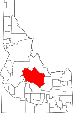 الموقع ضمن ولاية Idaho | |
 موقع Idaho ضمن الولايات المتحدة | |
| الإحداثيات: 44°14′N 114°17′W / 44.23°N 114.29°W | |
| البلد | |
| State | |
| تأسست | January 8, 1881 |
| السمِيْ | General Custer gold mine |
| Seat | Challis |
| Largest city | Challis |
| المساحة | |
| • الإجمالي | 4٬937 ميل² (12٬790 كم²) |
| • البر | 4٬921 ميل² (12٬750 كم²) |
| • الماء | 16 ميل² (40 كم²) 0.3% |
| التعداد (2010) | |
| • الإجمالي | 4٬368 |
| • Estimate (2018) | 4٬280 |
| • الكثافة | 0٫88/sq mi (0٫34/km2) |
| منطقة التوقيت | UTC−7 (Mountain) |
| • الصيف (التوقيت الصيفي) | UTC−6 (MDT) |
| Congressional district | 2nd |
| الموقع الإلكتروني | www |
مقاطعة كستر إنگليزية: Custer County هي إحدى مقاطعات ولاية أيداهو في الولايات المتحدة الأمريكية. وفي تعداد 2010 بلغ تعداد المقاطعة 4,368 نسمة.[1] The county seat is Challis.[2] Established in 1881, the county was named for the General Custer Mine, where gold was discovered five years earlier. Custer County relies on ranching, mining, and tourism as its main resources.[3]
. . . . . . . . . . . . . . . . . . . . . . . . . . . . . . . . . . . . . . . . . . . . . . . . . . . . . . . . . . . . . . . . . . . . . . . . . . . . . . . . . . . . . . . . . . . . . . . . . . . . . . . . . . . . . . . . . . . . . . . . . . . . . . . . . . . . . . . . . . . . . . . . . . . . . . . . . . . . . . . . . . . . . . . .
الجغرافيا
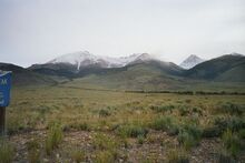
Salmon River و Big Lost River ينسابان عبر مقاطعة كستر.
المقاطعات المجاورة
- Lemhi County - شمال
- Butte County - شرق
- Blaine County - جنوب
- Elmore County - جنوب غرب
- Boise County - جنوب غرب
- Valley County - غرب
الديمغرافيا
| التعداد التاريخي | |||
|---|---|---|---|
| التعداد | Pop. | %± | |
| 1890 | 1٬870 | — | |
| 1900 | 2٬049 | 9٫6% | |
| 1910 | 3٬001 | 46٫5% | |
| 1920 | 3٬550 | 18٫3% | |
| 1930 | 3٬162 | −10٫9% | |
| 1940 | 3٬549 | 12٫2% | |
| 1950 | 3٬318 | −6٫5% | |
| 1960 | 2٬996 | −9٫7% | |
| 1970 | 2٬967 | −1�0% | |
| 1980 | 3٬385 | 14٫1% | |
| 1990 | 4٬133 | 22٫1% | |
| 2000 | 4٬342 | 5٫1% | |
| 2010 | 4٬368 | 0٫6% | |
| 2018 (تق.) | 4٬280 | [4] | −2�0% |
| U.S. Decennial Census[5] 1790-1960[6] 1900-1990[7] 1990-2000[8] 2010-2018[1] | |||
السياسة
| Year | Republican | Democratic | Third parties |
|---|---|---|---|
| 2016 | 73.6% 1,777 | 17.7% 427 | 8.7% 210 |
| 2012 | 74.1% 1,744 | 22.5% 530 | 3.4% 81 |
| 2008 | 72.0% 1,694 | 26.0% 611 | 2.0% 48 |
| 2004 | 74.7% 1,762 | 23.7% 559 | 1.6% 37 |
| 2000 | 77.0% 1,794 | 17.9% 416 | 5.2% 120 |
| 1996 | 53.9% 1,249 | 27.4% 635 | 18.7% 432 |
| 1992 | 38.3% 829 | 26.1% 564 | 35.6% 771 |
| 1988 | 66.1% 1,253 | 32.5% 616 | 1.4% 27 |
| 1984 | 77.1% 1,653 | 21.5% 461 | 1.4% 30 |
| 1980 | 73.5% 1,398 | 20.9% 398 | 5.6% 106 |
| 1976 | 60.3% 850 | 36.6% 516 | 3.1% 43 |
| 1972 | 69.1% 989 | 19.1% 274 | 11.8% 169 |
| 1968 | 50.0% 711 | 27.1% 385 | 23.0% 327 |
| 1964 | 50.2% 720 | 49.8% 714 | |
| 1960 | 43.7% 651 | 56.3% 838 | |
| 1956 | 60.3% 811 | 39.7% 533 | |
| 1952 | 69.7% 1,058 | 29.8% 452 | 0.5% 7 |
| 1948 | 48.7% 612 | 49.7% 625 | 1.6% 20 |
| 1944 | 48.0% 565 | 52.0% 613 | |
| 1940 | 45.8% 760 | 53.9% 894 | 0.3% 5 |
| 1936 | 37.3% 530 | 61.6% 875 | 1.1% 16 |
| 1932 | 33.8% 440 | 64.4% 839 | 1.8% 24 |
| 1928 | 55.3% 647 | 44.1% 516 | 0.7% 8 |
| 1924 | 46.0% 585 | 31.0% 394 | 23.0% 293 |
| 1920 | 67.2% 808 | 32.8% 394 | |
| 1916 | 32.2% 454 | 62.4% 879 | 5.4% 76 |
| 1912 | 27.4% 326 | 42.1% 501 | 30.5% 362 |
| 1908 | 43.1% 521 | 49.5% 598 | 7.4% 90 |
| 1904 | 51.3% 496 | 44.4% 429 | 4.3% 42 |
| 1900 | 30.7% 261 | 69.3% 590 |
التجمعات السكنية
المدن
. . . . . . . . . . . . . . . . . . . . . . . . . . . . . . . . . . . . . . . . . . . . . . . . . . . . . . . . . . . . . . . . . . . . . . . . . . . . . . . . . . . . . . . . . . . . . . . . . . . . . . . . . . . . . . . . . . . . . . . . . . . . . . . . . . . . . . . . . . . . . . . . . . . . . . . . . . . . . . . . . . . . . . . .
التجمعات غير المشهرة
- Ellis
- Goldburg
البلدات المهجورة
انظر أيضاً
الهامش
- ^ أ ب "State & County QuickFacts". United States Census Bureau. Archived from the original on July 9, 2011. Retrieved June 28, 2014.
- ^ "Find a County". National Association of Counties. Archived from the original on May 31, 2011. Retrieved June 7, 2011.
- ^ "Custer County, Idaho | we are what America used to be". www.co.custer.id.us (in الإنجليزية الأمريكية). Retrieved April 4, 2018.
- ^ "Population and Housing Unit Estimates". Retrieved September 6, 2019.
- ^ "U.S. Decennial Census". United States Census Bureau. Retrieved June 28, 2014.
- ^ "Historical Census Browser". University of Virginia Library. Retrieved June 28, 2014.
- ^ "Population of Counties by Decennial Census: 1900 to 1990". United States Census Bureau. Retrieved June 28, 2014.
- ^ "Census 2000 PHC-T-4. Ranking Tables for Counties: 1990 and 2000" (PDF). United States Census Bureau. Retrieved June 28, 2014.
- ^ Leip, David. "Dave Leip's Atlas of U.S. Presidential Elections". uselectionatlas.org. Retrieved April 4, 2018.
وصلات خارجية
للاستزادة

|
Lemhi County | 
| ||
| Butte County | Valley County | |||
| Blaine County | Elmore County and Boise County |
- Pages using gadget WikiMiniAtlas
- CS1 الإنجليزية الأمريكية-language sources (en-us)
- Short description is different from Wikidata
- Coordinates on Wikidata
- مقاطعات Idaho
- Pages using infobox U.S. county with unknown parameters
- Articles containing إنگليزية-language text
- Pages using Lang-xx templates
- Pages using US Census population needing update
- مقاطعة كستر، أيداهو
- تأسيسات 1881 في إقليم أيداهو
- أماكن مأهولة تأسست في 1881
- مقاطعات ولاية أيداهو الأمريكية

