مقاطعة كراولي، كولورادو
Crowley County | |
|---|---|
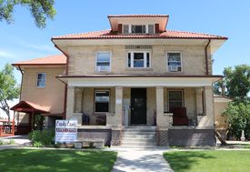
 The Crowley County Justice Center in Ordway. | |
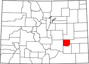
 الموقع ضمن ولاية Colorado | |
 موقع Colorado ضمن الولايات المتحدة | |
| الإحداثيات: 38°20′N 103°47′W / 38.33°N 103.79°W | |
| البلد | |
| State | |
| تأسست | May 29, 1911 |
| السمِيْ | جون كراولي |
| Seat | Ordway |
| Largest town | Ordway |
| المساحة | |
| • الإجمالي | 800 ميل² (2٬000 كم²) |
| • البر | 787 ميل² (2٬040 كم²) |
| • الماء | 13 ميل² (30 كم²) 1.6%% |
| التعداد | |
| • Estimate (2019) | 6٬061 |
| • الكثافة | 7٫4/sq mi (2٫9/km2) |
| منطقة التوقيت | UTC−7 (Mountain) |
| • الصيف (التوقيت الصيفي) | UTC−6 (MDT) |
| Congressional district | 4th |
| الموقع الإلكتروني | www |
مقاطعة كراولي إنگليزية: Crowley County هي إحدى مقاطعات ولاية كولورادو في الولايات المتحدة.
. . . . . . . . . . . . . . . . . . . . . . . . . . . . . . . . . . . . . . . . . . . . . . . . . . . . . . . . . . . . . . . . . . . . . . . . . . . . . . . . . . . . . . . . . . . . . . . . . . . . . . . . . . . . . . . . . . . . . . . . . . . . . . . . . . . . . . . . . . . . . . . . . . . . . . . . . . . . . . . . . . . . . . . .
السياسة
Crowley is a predominantly Republican county. No Democratic presidential nominee has won Crowley County since Lyndon Johnson's 1964 landslide. Before that time, the county largely followed the patterns of Colorado politics in general, from strongly Democratic during the William Jennings Bryan and Woodrow Wilson eras to Republican leaning from the time of Wendell Willkie onwards.
| Year | Republican | Democratic | Others |
|---|---|---|---|
| 2016 | 70.7% 1,079 | 22.2% 339 | 7.1% 109 |
| 2012 | 61.5% 924 | 35.6% 535 | 2.9% 43 |
| 2008 | 62.6% 976 | 35.4% 552 | 1.9% 30 |
| 2004 | 67.4% 1,006 | 32.0% 478 | 0.6% 9 |
| 2000 | 59.2% 855 | 35.4% 511 | 5.5% 79 |
| 1996 | 49.6% 680 | 40.8% 559 | 9.6% 132 |
| 1992 | 41.3% 602 | 39.1% 570 | 19.6% 286 |
| 1988 | 57.5% 862 | 42.0% 630 | 0.5% 8 |
| 1984 | 65.0% 993 | 33.9% 517 | 1.1% 17 |
| 1980 | 62.9% 926 | 32.0% 472 | 5.1% 75 |
| 1976 | 54.9% 834 | 43.9% 667 | 1.2% 18 |
| 1972 | 70.7% 1,094 | 26.7% 414 | 2.6% 40 |
| 1968 | 50.4% 775 | 36.7% 565 | 12.9% 199 |
| 1964 | 41.5% 690 | 58.2% 967 | 0.4% 6 |
| 1960 | 60.9% 1,099 | 39.1% 705 | 0.1% 1 |
| 1956 | 62.1% 1,220 | 37.9% 745 | 0.1% 1 |
| 1952 | 67.8% 1,546 | 31.8% 726 | 0.4% 9 |
| 1948 | 50.3% 1,027 | 49.2% 1,004 | 0.4% 9 |
| 1944 | 62.9% 1,214 | 36.8% 710 | 0.3% 5 |
| 1940 | 62.2% 1,419 | 37.3% 850 | 0.5% 12 |
| 1936 | 43.1% 920 | 54.5% 1,163 | 2.4% 51 |
| 1932 | 38.3% 811 | 59.8% 1,266 | 1.9% 40 |
| 1928 | 65.4% 1,243 | 33.4% 635 | 1.2% 22 |
| 1924 | 50.2% 1,087 | 30.8% 667 | 19.0% 410 |
| 1920 | 60.6% 1,348 | 35.6% 792 | 3.7% 83 |
| 1916 | 40.5% 847 | 55.4% 1,160 | 4.1% 86 |
| 1912 | 28.4% 467 | 43.7% 719 | 28.0% 461 |
Communities
البلدات
انظر أيضاً
- Outline of Colorado
- Index of Colorado-related articles
- Colorado census statistical areas
- National Register of Historic Places listings in Crowley County, Colorado
- Pike's Peak Gold Rush
المراجع
- ^ Leip, David. "Dave Leip's Atlas of U.S. Presidential Elections". uselectionatlas.org. Retrieved May 26, 2017.
External links
- Crowley County Government website
- Crowley County History
- Colorado County Evolution by Don Stanwyck
- Colorado Historical Society

|
Lincoln County | El Paso County | 
| |
| Kiowa County | Pueblo County | |||
| Otero County |
- Pages using gadget WikiMiniAtlas
- Short description is different from Wikidata
- Coordinates on Wikidata
- مقاطعات Colorado
- Articles containing إنگليزية-language text
- Pages using Lang-xx templates
- Pages with empty portal template
- Crowley County, Colorado
- Colorado counties
- 1911 establishments in Colorado
- Populated places established in 1911
- Eastern Plains
- مقاطعات ولاية كولورادو الأمريكية