مقاطعة كانيار
كانيار
Cañar | |
|---|---|
| مقاطعة كانيار | |
 | |
 Cañar Province in Ecuador | |
 كانتونات مقاطعة كانيار | |
| البلد | |
| العاصمة | Azogues |
| الحكومة | |
| • Provincial Prefect | Marcelo Jaramillo |
| المساحة | |
| • الإجمالي | 3٬647 كم² (1٬408 ميل²) |
| التعداد (تعداد 2022)[1] | |
| • الإجمالي | 227٬578 |
| • الكثافة | 62/km2 (160/sq mi) |
| منطقة التوقيت | ECT |
| لوحة السيارة | U |
| HDI (2017) | 0.727[2] high · 12th |
| الموقع الإلكتروني | www |
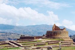
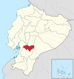
كانيار ( Cañar ؛ النطق الإسپاني: [kaˈɲaɾ]) هي مقاطعة في الإكوادور. The capital is Azogues. At the time of census 2010 the province had a population of 225,184.[3] It contains the 16th-century ruins of Ingapirca, the best-known Inca settlement in Ecuador and a product of their conquest of the indigenous Cañari.
. . . . . . . . . . . . . . . . . . . . . . . . . . . . . . . . . . . . . . . . . . . . . . . . . . . . . . . . . . . . . . . . . . . . . . . . . . . . . . . . . . . . . . . . . . . . . . . . . . . . . . . . . . . . . . . . . . . . . . . . . . . . . . . . . . . . . . . . . . . . . . . . . . . . . . . . . . . . . . . . . . . . . . . .
السكان
Ethnic groups as of the Ecuadorian census of 2010:[4]
- مستيزو 76.7%
- Indigenous 15.2%
- White 4.3%
- Afro-Ecuadorian 2.6%
- Montubio 1.1%
- غيرهم 0.2%
الكانتونات
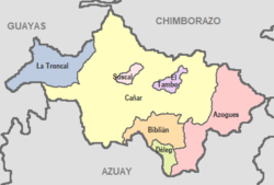
The province is divided into 7 cantons. The following table lists each with its population at the time of the 2001 census, its area in square kilometres (km²), and the name of the canton seat or capital.[5]
| العلم | الكانتون | Pop. (2019) | Area (km²) | Seat/Capital |
|---|---|---|---|---|
| Azogues | 85,030 | 613 | Azogues | |
| بيبليان | 23,590 | 227 | بيبليان | |
| كانيار | 68,190 | 1,804 | كانيار | |
| ديلگ | 6,760 | 78 | ديلگ | |
| إل تامبو | 12,200 | 65 | El Tambo | |
| سوسكال | 6,390 | 31 | سوسكال | |
| لا ترونكال | 74,680 | 328 | لا ترونكال |
انظر أيضاً
المراجع
- ^ Citypopulation.de
- ^ Villalba, Juan. "Human Development Index in Ecuador". Scribd (in الإسبانية). Retrieved 2019-02-05.
- ^ INEC, Población total y tasa brutas de natalidad, mortalidad general, mortalidad infantil y materna según regiones y provincias de residencia habitual, año 2005 Archived 2008-02-06 at the Wayback Machine, Retrieved October 13, 2007.
- ^ "Resultados" (PDF).
- ^ Cantons of Ecuador. Statoids.com. Retrieved 4 November 2009.
وصلات خارجية
- (in إسپانية) Gobierno de la Provincia del Cañar, official website
- CS1 الإسبانية-language sources (es)
- Pages using gadget WikiMiniAtlas
- Short description is different from Wikidata
- Articles with hatnote templates targeting a nonexistent page
- Pages using infobox settlement with no coordinates
- Articles with إسپانية-language sources (es)
- Coordinates on Wikidata
- مقاطعة كانيار
- مقاطعات الإكوادور
