مقاطعة فورد، كانزس
Ford County | |
|---|---|
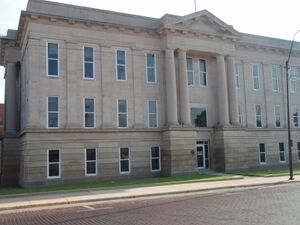
 Ford County Courthouse in Dodge City (2009) | |
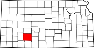
 الموقع ضمن ولاية Kansas | |
 موقع Kansas ضمن الولايات المتحدة | |
| الإحداثيات: 37°42′N 99°54′W / 37.700°N 99.900°W | |
| البلد | |
| State | |
| تأسست | February 26, 1867 |
| السمِيْ | James Ford |
| Seat | Dodge City |
| Largest city | Dodge City |
| المساحة | |
| • الإجمالي | 1٬099 ميل² (2٬850 كم²) |
| • البر | 1٬098 ميل² (2٬840 كم²) |
| • الماء | 0٫8 ميل² (2 كم²) 0.07%% |
| التعداد | |
| • Estimate (2018) | 33٬888 |
| • الكثافة | 31/sq mi (12/km2) |
| منطقة التوقيت | UTC−6 (Central) |
| • الصيف (التوقيت الصيفي) | UTC−5 (CDT) |
| Congressional district | 1st |
| الموقع الإلكتروني | fordcounty.net |
مقاطعة فورد إنگليزية: Ford County هي إحدى المقاطعات في ولاية كانزس، الولايات المتحدة.
 Railroad crew works on the Atchison, Topeka and Santa Fe tracks near Bellefont, 1974. Photo by Charles O'Rear. |
. . . . . . . . . . . . . . . . . . . . . . . . . . . . . . . . . . . . . . . . . . . . . . . . . . . . . . . . . . . . . . . . . . . . . . . . . . . . . . . . . . . . . . . . . . . . . . . . . . . . . . . . . . . . . . . . . . . . . . . . . . . . . . . . . . . . . . . . . . . . . . . . . . . . . . . . . . . . . . . . . . . . . . . .
Government
Presidential elections
Ford County has been strongly Republican for most of its history, especially in recent elections. Only eight Democratic presidential candidates from 1880 to 2020 have carried the county, the most recent being Jimmy Carter in 1976.
| Year | Republican | Democratic | Third Parties |
|---|---|---|---|
| 2020 | 65.1% 5,803 | 33.1% 2,947 | 1.85% 165 |
| 2016 | 66.3% 5,114 | 27.8% 2,149 | 5.9% 455 |
| 2012 | 67.0% 5,602 | 31.1% 2,600 | 1.9% 160 |
| 2008 | 64.6% 5,730 | 33.7% 2,991 | 1.6% 143 |
| 2004 | 73.6% 6,632 | 25.4% 2,286 | 1.1% 98 |
| 2000 | 67.9% 6,050 | 28.8% 2,566 | 3.4% 301 |
| 1996 | 61.3% 5,681 | 28.4% 2,628 | 10.3% 958 |
| 1992 | 41.9% 4,342 | 25.4% 2,635 | 32.6% 3,379 |
| 1988 | 58.6% 5,685 | 39.4% 3,817 | 2.0% 195 |
| 1984 | 69.7% 6,935 | 29.3% 2,914 | 1.0% 98 |
| 1980 | 58.9% 5,686 | 33.1% 3,194 | 8.1% 781 |
| 1976 | 47.6% 4,679 | 50.2% 4,934 | 2.2% 214 |
| 1972 | 67.1% 6,232 | 30.2% 2,804 | 2.7% 249 |
| 1968 | 52.8% 4,645 | 36.3% 3,191 | 10.9% 961 |
| 1964 | 39.7% 3,481 | 59.6% 5,221 | 0.7% 59 |
| 1960 | 57.7% 5,200 | 42.1% 3,792 | 0.3% 25 |
| 1956 | 66.8% 5,561 | 32.6% 2,710 | 0.6% 49 |
| 1952 | 69.0% 6,359 | 29.8% 2,748 | 1.2% 114 |
| 1948 | 47.2% 4,089 | 50.8% 4,396 | 2.0% 177 |
| 1944 | 57.2% 4,110 | 41.7% 2,994 | 1.1% 77 |
| 1940 | 52.0% 4,356 | 47.2% 3,954 | 0.9% 72 |
| 1936 | 38.7% 3,378 | 61.1% 5,335 | 0.2% 17 |
| 1932 | 41.6% 3,335 | 55.4% 4,442 | 3.0% 238 |
| 1928 | 71.6% 4,893 | 27.4% 1,870 | 1.1% 72 |
| 1924 | 58.0% 3,449 | 26.1% 1,551 | 15.9% 948 |
| 1920 | 61.9% 3,305 | 35.2% 1,879 | 2.9% 155 |
| 1916 | 40.3% 2,337 | 52.5% 3,044 | 7.2% 420 |
| 1912 | 19.2% 529 | 40.8% 1,125 | 40.0% 1,104 |
| 1908 | 53.3% 1,333 | 43.5% 1,089 | 3.2% 80 |
| 1904 | 64.8% 1,148 | 29.7% 526 | 5.5% 98 |
| 1900 | 50.5% 653 | 47.1% 610 | 2.4% 31 |
| 1896 | 45.8% 555 | 53.0% 643 | 1.2% 15 |
| 1892 | 53.4% 648 | 46.6% 565 | |
| 1888 | 52.5% 882 | 37.5% 630 | 10.1% 169 |
Laws
Ford County was a prohibition, or "dry", county until the Kansas Constitution was amended in 1986 and voters approved the sale of alcoholic liquor by the individual drink with a 30% food sales requirement.[2]
Education
Colleges
Unified school districts
Communities
Cities
Census-designated places
. . . . . . . . . . . . . . . . . . . . . . . . . . . . . . . . . . . . . . . . . . . . . . . . . . . . . . . . . . . . . . . . . . . . . . . . . . . . . . . . . . . . . . . . . . . . . . . . . . . . . . . . . . . . . . . . . . . . . . . . . . . . . . . . . . . . . . . . . . . . . . . . . . . . . . . . . . . . . . . . . . . . . . . .
Other unincorporated places
Townships
Ford County is divided into 14 townships. The city of Dodge City is considered governmentally independent and is excluded from the census figures for the townships. In the following table, the population center is the largest city (or cities) included in that township's population total, if it is of a significant size.
| Township | FIPS | Population center |
Population | Population density /km2 (/sq mi) |
Land area km2 (sq mi) |
Water area km2 (sq mi) |
Water % | Geographic coordinates |
|---|---|---|---|---|---|---|---|---|
| Bloom | 07375 | 113 | 1 (2) | 144 (55) | 0 (0) | 0% | 37°30′23″N 99°55′4″W / 37.50639°N 99.91778°W | |
| Bucklin | 09025 | 900 | 3 (8) | 285 (110) | 0 (0) | 0.02% | 37°34′44″N 99°37′9″W / 37.57889°N 99.61917°W | |
| Concord | 15150 | 117 | 1 (2) | 187 (72) | 0 (0) | 0.11% | 37°36′36″N 100°5′52″W / 37.61000°N 100.09778°W | |
| Dodge | 18225 | 899 | 13 (33) | 70 (27) | 0 (0) | 0.21% | 37°47′0″N 100°0′52″W / 37.78333°N 100.01444°W | |
| Enterprise | 21450 | 1,113 | 6 (17) | 175 (67) | 0 (0) | 0.19% | 37°40′47″N 99°57′8″W / 37.67972°N 99.95222°W | |
| Fairview | 22500 | 346 | 2 (5) | 188 (73) | 0 (0) | 0.06% | 37°45′11″N 100°8′57″W / 37.75306°N 100.14917°W | |
| Ford | 23750 | 456 | 2 (5) | 249 (96) | 0 (0) | 0.01% | 37°36′58″N 99°46′27″W / 37.61611°N 99.77417°W | |
| Grandview | 27350 | 784 | 3 (9) | 226 (87) | 0 (0) | 0.20% | 37°47′10″N 99°55′54″W / 37.78611°N 99.93167°W | |
| Richland | 59300 | 931 | 9 (24) | 99 (38) | 0 (0) | 0.17% | 37°42′10″N 100°2′19″W / 37.70278°N 100.03861°W | |
| Royal | 61575 | 105 | 1 (1) | 185 (72) | 0 (0) | 0.06% | 37°51′51″N 100°6′44″W / 37.86417°N 100.11222°W | |
| Sodville | 66150 | 110 | 1 (2) | 145 (56) | 0 (0) | 0.01% | 37°31′16″N 99°45′6″W / 37.52111°N 99.75167°W | |
| Spearville | 67150 | 1,150 | 2 (6) | 479 (185) | 0 (0) | 0.03% | 37°47′58″N 99°45′4″W / 37.79944°N 99.75111°W | |
| Wheatland | 77675 | 170 | 1 (2) | 193 (74) | 0 (0) | 0% | 37°48′58″N 99°37′22″W / 37.81611°N 99.62278°W | |
| Wilburn | 79100 | 88 | 0 (1) | 187 (72) | 0 (0) | 0% | 37°31′22″N 100°7′10″W / 37.52278°N 100.11944°W | |
| Sources: "Census 2000 U.S. Gazetteer Files". U.S. Census Bureau, Geography Division. Archived from the original on 2002-08-02. | ||||||||
Notable people
Numerous figures of the American Old West lived in Dodge City during its period as a frontier cowtown. These included, most notably, lawmen Wyatt Earp and Bat Masterson, and gunfighter Doc Holliday.[3]
See also
. . . . . . . . . . . . . . . . . . . . . . . . . . . . . . . . . . . . . . . . . . . . . . . . . . . . . . . . . . . . . . . . . . . . . . . . . . . . . . . . . . . . . . . . . . . . . . . . . . . . . . . . . . . . . . . . . . . . . . . . . . . . . . . . . . . . . . . . . . . . . . . . . . . . . . . . . . . . . . . . . . . . . . . .
References
- ^ http://uselectionatlas.org/RESULTS
- ^ "Map of Wet and Dry Counties". Alcoholic Beverage Control, Kansas Department of Revenue. November 2006. Archived from the original on 2007-10-08. Retrieved 2007-12-28.
- ^ "More Dodge City History". Dodge City Convention and Visitors Bureau. Retrieved 2011-09-23.
Further reading
- Handbook of Ford County, Kansas; C.S. Burch Publishing Co; 32 pages; 1887.
- Atlas and Plat Book of Ford County, Kansas; Kenyon Co; 54 pages; 1916.
- Standard Atlas of Ford County, Kansas; Geo. A. Ogle & Co; 63 pages; 1906.
External links
- County
- Historical
- Ford County History from FCHS, Dodge City, KS
- Ford County GenWeb
- Ford County from American History and Genealogy Project (AHGP)
- Maps
- Ford County Maps: Current, Historic, KDOT
- Kansas Highway Maps: Current, Historic, KDOT
- Kansas Railroad Maps: Current, 1996, 1915, KDOT and Kansas Historical Society

|
Edwards County | Hodgeman County | 
| |
| Kiowa County | Gray County | |||
| Clark County | Meade County |
قالب:Midwestern U.S. majority-minority counties خطأ لوا في وحدة:Authority_control على السطر 278: attempt to call field '_showMessage' (a nil value). 37°42′N 99°54′W / 37.700°N 99.900°W{{#coordinates:}}: لا يمكن أن يكون هناك أكثر من وسم أساسي واحد لكل صفحة
- Pages using gadget WikiMiniAtlas
- صفحات ذات وسوم إحداثيات غير صحيحة
- Short description is different from Wikidata
- Coordinates on Wikidata
- مقاطعات Kansas
- Articles containing إنگليزية-language text
- Pages using Lang-xx templates
- Articles with hatnote templates targeting a nonexistent page
- Pages with empty portal template
- Official website different in Wikidata and Wikipedia
- Ford County, Kansas
- Kansas counties
- 1867 establishments in Kansas
- Populated places established in 1867
- مقاطعات ولاية كانزاس الأمريكية
