مقاطعة رسل، ڤرجينيا
Russell County | |
|---|---|
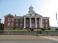
 Russell County Courthouse in Lebanon | |
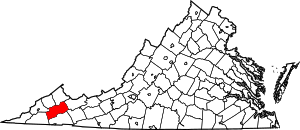
 الموقع ضمن ولاية Virginia | |
 موقع Virginia ضمن الولايات المتحدة | |
| الإحداثيات: 36°56′N 82°06′W / 36.94°N 82.10°W | |
| البلد | |
| State | |
| تأسست | January 2, 1786 |
| السمِيْ | William Russell |
| Seat | Lebanon |
| Largest town | Lebanon |
| المساحة | |
| • الإجمالي | 477 ميل² (1٬240 كم²) |
| • البر | 474 ميل² (1٬230 كم²) |
| • الماء | 2٫9 ميل² (8 كم²) 0.6% |
| التعداد (2010) | |
| • الإجمالي | 28٬897 |
| • Estimate (2018)[1] | 26٬748 |
| • الكثافة | 61/sq mi (23/km2) |
| منطقة التوقيت | UTC−5 (Eastern) |
| • الصيف (التوقيت الصيفي) | UTC−4 (EDT) |
| Congressional district | 9th |
| الموقع الإلكتروني | www |
مقاطعة رسل إنگليزية: Russell County هي إحدى المقاطعات في ولاية ڤرجينيا في الولايات المتحدة الأمريكية.
. . . . . . . . . . . . . . . . . . . . . . . . . . . . . . . . . . . . . . . . . . . . . . . . . . . . . . . . . . . . . . . . . . . . . . . . . . . . . . . . . . . . . . . . . . . . . . . . . . . . . . . . . . . . . . . . . . . . . . . . . . . . . . . . . . . . . . . . . . . . . . . . . . . . . . . . . . . . . . . . . . . . . . . .
التاريخ
الجغرافيا
المقاطعات المجاورة
- Dickenson County – الشمال الغربي
- Buchanan County – الشمال
- Tazewell County – الشرق
- Smyth County – southeast
- Washington County – south
- Scott County – southwest
- Wise County – west
الطرق السريعة الرئيسية
الديمغرافيا
| التعداد التاريخي | |||
|---|---|---|---|
| التعداد | Pop. | %± | |
| 1790 | 3٬338 | — | |
| 1800 | 4٬808 | 44�0% | |
| 1810 | 6٬319 | 31٫4% | |
| 1820 | 5٬536 | −12٫4% | |
| 1830 | 6٬714 | 21٫3% | |
| 1840 | 7٬878 | 17٫3% | |
| 1850 | 11٬919 | 51٫3% | |
| 1860 | 10٬280 | −13٫8% | |
| 1870 | 11٬103 | 8�0% | |
| 1880 | 13٬906 | 25٫2% | |
| 1890 | 16٬126 | 16�0% | |
| 1900 | 18٬031 | 11٫8% | |
| 1910 | 23٬474 | 30٫2% | |
| 1920 | 26٬786 | 14٫1% | |
| 1930 | 25٬957 | −3٫1% | |
| 1940 | 26٬627 | 2٫6% | |
| 1950 | 26٬818 | 0٫7% | |
| 1960 | 26٬290 | −2�0% | |
| 1970 | 24٬533 | −6٫7% | |
| 1980 | 31٬761 | 29٫5% | |
| 1990 | 28٬667 | −9٫7% | |
| 2000 | 30٬308 | 5٫7% | |
| 2010 | 28٬897 | −4٫7% | |
| 2018 (تق.) | 26٬748 | [1] | −7٫4% |
| U.S. Decennial Census[2] 1790–1960[3] 1900–1990[4] 1990–2000[5] 2010–2018[1] | |||
السياسة
| Year | Republican | Democratic | Third parties |
|---|---|---|---|
| 2016 | 77.8% 9,521 | 19.0% 2,330 | 3.2% 395 |
| 2012 | 67.7% 8,180 | 30.8% 3,718 | 1.6% 190 |
| 2008 | 55.6% 6,389 | 42.9% 4,932 | 1.5% 173 |
| 2004 | 53.2% 6,077 | 45.2% 5,167 | 1.6% 179 |
| 2000 | 46.9% 5,065 | 50.4% 5,442 | 2.7% 285 |
| 1996 | 36.6% 3,706 | 53.7% 5,437 | 9.7% 985 |
| 1992 | 33.9% 3,891 | 56.4% 6,480 | 9.7% 1,113 |
| 1988 | 40.7% 4,374 | 57.9% 6,222 | 1.5% 157 |
| 1984 | 45.5% 5,738 | 53.7% 6,760 | 0.8% 101 |
| 1980 | 43.9% 4,778 | 53.0% 5,764 | 3.1% 332 |
| 1976 | 40.2% 4,287 | 56.4% 6,014 | 3.4% 366 |
| 1972 | 58.9% 5,010 | 39.6% 3,367 | 1.5% 125 |
| 1968 | 43.5% 3,858 | 40.1% 3,554 | 16.5% 1,460 |
| 1964 | 40.9% 3,012 | 58.8% 4,330 | 0.3% 25 |
| 1960 | 46.4% 3,044 | 53.3% 3,496 | 0.2% 14 |
| 1956 | 49.1% 3,550 | 50.4% 3,641 | 0.5% 33 |
| 1952 | 47.3% 2,937 | 52.4% 3,253 | 0.3% 16 |
| 1948 | 46.7% 2,447 | 51.3% 2,689 | 2.0% 107 |
| 1944 | 44.6% 2,385 | 55.1% 2,945 | 0.4% 20 |
| 1940 | 40.0% 2,080 | 59.8% 3,109 | 0.2% 11 |
| 1936 | 33.6% 1,599 | 66.0% 3,143 | 0.4% 18 |
| 1932 | 29.7% 1,386 | 70.1% 3,274 | 0.2% 11 |
| 1928 | 44.4% 2,006 | 55.6% 2,511 | |
| 1924 | 41.3% 1,848 | 57.0% 2,554 | 1.7% 76 |
| 1920 | 50.9% 1,772 | 49.0% 1,704 | 0.1% 5 |
| 1916 | 47.1% 1,410 | 52.5% 1,570 | 0.4% 11 |
| 1912 | 23.3% 588 | 51.5% 1,298 | 25.1% 633 |
. . . . . . . . . . . . . . . . . . . . . . . . . . . . . . . . . . . . . . . . . . . . . . . . . . . . . . . . . . . . . . . . . . . . . . . . . . . . . . . . . . . . . . . . . . . . . . . . . . . . . . . . . . . . . . . . . . . . . . . . . . . . . . . . . . . . . . . . . . . . . . . . . . . . . . . . . . . . . . . . . . . . . . . .
See also
References
- ^ أ ب ت "County Population Totals and Components of Change: 2010-2018". Retrieved May 25, 2019.
- ^ "U.S. Decennial Census". United States Census Bureau. Retrieved January 5, 2014.
- ^ "Historical Census Browser". University of Virginia Library. Retrieved January 5, 2014.
- ^ "Population of Counties by Decennial Census: 1900 to 1990". United States Census Bureau. Retrieved January 5, 2014.
- ^ "Census 2000 PHC-T-4. Ranking Tables for Counties: 1990 and 2000" (PDF). United States Census Bureau. Retrieved January 5, 2014.
- ^ Leip, David. "Dave Leip's Atlas of U.S. Presidential Elections". uselectionatlas.org. Retrieved 11 April 2018.
External links
- Pages using gadget WikiMiniAtlas
- Short description is different from Wikidata
- Coordinates on Wikidata
- مقاطعات Virginia
- Pages using infobox U.S. county with unknown parameters
- Articles containing إنگليزية-language text
- Pages using Lang-xx templates
- Jct template errors
- Pages using US Census population needing update
- مقاطعة رسل، ڤرجينيا
- تأسيسات 1786 في الولايات المتحدة
- مقاطعات أپالاشيا
- مقاطعات ولاية فيرجينيا الأمريكية