مقاطعة بويسي، أيداهو
Boise County | |
|---|---|
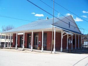
 Boise County Courthouse in Idaho City | |
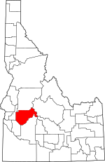
 الموقع ضمن ولاية Idaho | |
 موقع Idaho ضمن الولايات المتحدة | |
| الإحداثيات: 44°01′N 115°44′W / 44.01°N 115.74°W | |
| البلد | |
| State | |
| تأسست | February 4, 1864 |
| السمِيْ | نهر بويسي |
| Seat | Idaho City |
| Largest city | Horseshoe Bend |
| المساحة | |
| • الإجمالي | 1٬907 ميل² (4٬940 كم²) |
| • البر | 1٬899 ميل² (4٬920 كم²) |
| • الماء | 7٫4 ميل² (19 كم²) 0.4% |
| التعداد (2010) | |
| • الإجمالي | 7٬028 |
| • Estimate (2020) | 8٬065 |
| • الكثافة | 3٫7/sq mi (1٫4/km2) |
| منطقة التوقيت | UTC−7 (Mountain) |
| • الصيف (التوقيت الصيفي) | UTC−6 (MDT) |
| Congressional district | 1st |
| الموقع الإلكتروني | www |
مقاطعة بويسي إنگليزية: Boise County هي إحدى مقاطعات ولاية أيداهو في الولايات المتحدة الأمريكية. وفي تعداد الولايات المتحدة 2010 بلغ عدد السكان 7,028 نسمة.[1] مقر المقاطعة هو أيداهو سيتي التاريخية،[2] التي ترتبط عبر سلسلة من الطرق المعبدة وغير المعبدة بكل من لومان وسنترڤل وپليسرڤل وپيونيرڤل و ستار رانش، و كراوتش وگاردن ڤالي و هورسشو بند.
مقاطعة بويسي هي جزء من بويسي، أيداهو المنطقة الإحصائية العمرانية.
. . . . . . . . . . . . . . . . . . . . . . . . . . . . . . . . . . . . . . . . . . . . . . . . . . . . . . . . . . . . . . . . . . . . . . . . . . . . . . . . . . . . . . . . . . . . . . . . . . . . . . . . . . . . . . . . . . . . . . . . . . . . . . . . . . . . . . . . . . . . . . . . . . . . . . . . . . . . . . . . . . . . . . . .
المقاطعات المجاورة
- Valley County - north
- Custer County - east
- Elmore County - south
- Ada County - southwest
- Gem County - northwest
المناطق المحمية الوطنية
- Boise National Forest (part)
- Sawtooth National Recreation Area (part)
- Sawtooth Wilderness (part)
الطرق السريعة الرئيسية
- Invalid type: SH - Ponderosa Pine Scenic Byway
- Invalid type: SH
- Invalid type: SH - Payette River Scenic Byway
الديمغرافيا
| التعداد التاريخي | |||
|---|---|---|---|
| التعداد | Pop. | %± | |
| 1870 | 3٬834 | — | |
| 1880 | 3٬214 | −16٫2% | |
| 1890 | 3٬342 | 4�0% | |
| 1900 | 4٬174 | 24٫9% | |
| 1910 | 5٬250 | 25٫8% | |
| 1920 | 1٬822 | −65٫3% | |
| 1930 | 1٬847 | 1٫4% | |
| 1940 | 2٬333 | 26٫3% | |
| 1950 | 1٬776 | −23٫9% | |
| 1960 | 1٬646 | −7٫3% | |
| 1970 | 1٬763 | 7٫1% | |
| 1980 | 2٬999 | 70٫1% | |
| 1990 | 3٬509 | 17�0% | |
| 2000 | 6٬670 | 90٫1% | |
| 2010 | 7٬028 | 5٫4% | |
| 2020 (تق.) | 8٬065 | [3] | 14٫8% |
| US Decennial Census[4] 1790-1960[5] 1900-1990[6] 1990-2000[7] 2010-2020[1] | |||
التجمعات
المدن
Census-designated places
Unincorporated communities
- Brownlee[8]
- Centerville
- Gardena
- Grandjean[9]
- Grimes Pass[10]
- New Centerville[11]
- Pioneerville
- Quartzburg
- Washington Mill[12]
السياسة
Boise County voters are reliably Republican. In only one national election since 1948 has the county selected the Democratic Party candidate.
| Year | Republican | Democratic | Third parties |
|---|---|---|---|
| 2020 | 72.3% 3,485 | 25.0% 1,204 | 2.8% 133 |
| 2016 | 70.1% 2,673 | 20.4% 777 | 9.6% 364 |
| 2012 | 66.3% 2,284 | 30.6% 1,053 | 3.2% 109 |
| 2008 | 64.5% 2,433 | 32.9% 1,240 | 2.7% 100 |
| 2004 | 70.9% 2,501 | 27.5% 970 | 1.6% 56 |
| 2000 | 66.1% 2,019 | 24.4% 745 | 9.5% 291 |
| 1996 | 53.3% 1,576 | 29.7% 879 | 17.0% 504 |
| 1992 | 39.3% 912 | 26.9% 623 | 33.8% 785 |
| 1988 | 61.1% 1,044 | 36.3% 620 | 2.7% 46 |
| 1984 | 72.6% 1,249 | 25.3% 436 | 2.1% 36 |
| 1980 | 61.4% 1,134 | 28.1% 518 | 10.5% 194 |
| 1976 | 58.6% 684 | 37.1% 433 | 4.3% 50 |
| 1972 | 66.3% 676 | 25.1% 256 | 8.6% 88 |
| 1968 | 55.6% 450 | 25.3% 205 | 19.0% 154 |
| 1964 | 47.9% 414 | 52.1% 450 | |
| 1960 | 51.4% 456 | 48.7% 432 | |
| 1956 | 66.7% 570 | 33.3% 285 | |
| 1952 | 67.5% 655 | 31.9% 309 | 0.6% 6 |
| 1948 | 46.5% 437 | 51.0% 479 | 2.6% 24 |
| 1944 | 45.0% 464 | 54.7% 564 | 0.3% 3 |
| 1940 | 41.9% 489 | 58.0% 677 | 0.1% 1 |
| 1936 | 30.9% 368 | 65.6% 780 | 3.5% 42 |
| 1932 | 32.3% 342 | 64.1% 679 | 3.6% 38 |
| 1928 | 56.7% 521 | 42.3% 389 | 1.0% 9 |
| 1924 | 43.0% 388 | 22.0% 198 | 35.0% 316 |
| 1920 | 61.2% 588 | 38.8% 373 | |
| 1916 | 35.8% 657 | 57.2% 1,048 | 7.0% 128 |
| 1912 | 29.4% 651 | 33.5% 743 | 37.1% 822[أ] |
| 1908 | 45.5% 877 | 44.7% 862 | 9.8% 188 |
| 1904 | 56.3% 1,053 | 34.2% 639 | 9.5% 178 |
| 1900 | 44.9% 695 | 55.1% 852 |
. . . . . . . . . . . . . . . . . . . . . . . . . . . . . . . . . . . . . . . . . . . . . . . . . . . . . . . . . . . . . . . . . . . . . . . . . . . . . . . . . . . . . . . . . . . . . . . . . . . . . . . . . . . . . . . . . . . . . . . . . . . . . . . . . . . . . . . . . . . . . . . . . . . . . . . . . . . . . . . . . . . . . . . .
انظر أيضاً
ملاحظات
- ^ The leading "other" candidate, Progressive Theodore Roosevelt, received 504 votes while Socialist candidate Eugene Debs received 303 votes and Prohibition candidate Eugene Chafin 15 votes.
الهامش
- ^ أ ب "State & County QuickFacts". US Census Bureau. Archived from the original on July 7, 2011. Retrieved June 28, 2014.
- ^ "Find a County". National Association of Counties. Archived from the original on May 31, 2011. Retrieved June 7, 2011.
- ^ "County Population Totals: 2010-2020". Retrieved June 23, 2021.
- ^ "US Decennial Census". US Census Bureau. Retrieved June 28, 2014.
- ^ "Historical Census Browser". University of Virginia Library. Retrieved June 28, 2014.
- ^ "Population of Counties by Decennial Census: 1900 to 1990". US Census Bureau. Retrieved June 28, 2014.
- ^ "Census 2000 PHC-T-4. Ranking Tables for Counties: 1990 and 2000" (PDF). US Census Bureau. Retrieved June 28, 2014.
- ^ Brownlee ID Google Maps (accessed January 19, 2019)
- ^ Grandjean ID Google Maps (accessed January 19, 2019)
- ^ Grimes Pass ID Google Maps (accessed January 19, 2019)
- ^ New Centerville ID Google Maps (accessed January 19, 2019)
- ^ Washington Mill ID Google Maps (accessed January 19, 2019)
- ^ Leip, David. "Atlas of US Presidential Elections". uselectionatlas.org. Retrieved April 4, 2018.
وصلات خارجية
- Official website
- Boise County Parcel Maps - Boise County Parcel Maps
- State of Idaho site - Boise County profile
- Idaho Summits.com - Thompson Peak

|
Valley County | Gem County | 
| |
| Custer County | ||||
| Elmore County | Ada County |
- Pages using gadget WikiMiniAtlas
- Short description is different from Wikidata
- Coordinates on Wikidata
- مقاطعات Idaho
- Pages using infobox U.S. county with unknown parameters
- Articles containing إنگليزية-language text
- Pages using Lang-xx templates
- Jct template errors
- Pages using US Census population needing update
- مقاطعة بويسي، أيداهو
- أماكن مأهولة تأسست في 1864
- تأسيسات 1864 في إقليم أيداهو
- Boise metropolitan area
- مقاطعات ولاية أيداهو الأمريكية
