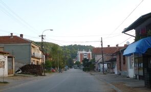
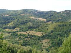
مدڤدزا
Medveđa
Медвеђа Medvegja | |
|---|---|
Town and municipality | |
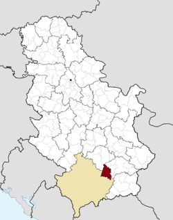 Location of the municipality of Medveđa within Serbia | |
| الإحداثيات: 42°50′35″N 21°35′05″E / 42.84306°N 21.58472°E | |
| Country | |
| المنطقة | Southern and Eastern Serbia |
| المحافظة | يابلانيتسا |
| Settlements | 44 |
| الحكومة | |
| • Mayor | Nebojša Arsić (SNS) |
| المساحة | |
| • Town | 19٫82 كم² (7٫65 ميل²) |
| • Municipality | 524 كم² (202 ميل²) |
| المنسوب | 440 m (1٬440 ft) |
| التعداد (2011 census)[3] | |
| • Town | 2٬848 |
| • كثافة Town | 140/km2 (370/sq mi) |
| • Municipality | 7٬438 |
| • كثافة Municipality | 14/km2 (37/sq mi) |
| منطقة التوقيت | UTC+1 (CET) |
| • الصيف (التوقيت الصيفي) | UTC+2 (CEST) |
| Postal code | 16240 |
| Area code | +381(0)16 |
| Car plates | LE |
| الموقع الإلكتروني | www |
قالب:Medvedja Labelled Map مدڤدزا (Medveđa ؛ سيريلية صربية: Медвеђа؛ تـُنطق [ˈmɛdvɛdʑa]؛ ألبانية: Medvegja؛ تـُنطق [ˈmedveɟa]) هي بلدة وبلدية تقع في محافظة يابلانيتسا في جنوب صربيا. وحسب تعداد 2011 ، يبلغ تعداد سكان البلدة 2,848 نسمة، بينما البلدية يبلغ تعدادها 7,438 نسمة.
أصل الاسم
The name is derived from the Serbian word medved (медвед), "bear", hence meaning "the place of the bears".
التاريخ
During the Roman period, there was a town (mansia) with the name Idimum located in the cadastral area of the modern town. Architectural debris dating to the 4th century AD lay at various locations of the town, as it was a transitory zone of Upper Moesia; travel and postal stations are among the finds.[4]
Toponyms such as Arbanaška and Đjake shows an Albanian presence in the Toplica and Southern Morava regions (located north-east of contemporary Kosovo) before the expulsion of Albanians during 1877–1878 period.[5][6] The rural parts of Jablanica valley and adjoining semi-mountainous interior was inhabited by compact Muslim Albanian population while Serbs in those areas lived near the river mouths and mountain slopes and both peoples inhabited other regions of the South Morava river basin.[7][8][9] As the wider Jabllanica region, Medveđa also had an Albanian majority. These Albanians were expelled by Serbian forces[10][11][12] in a way that today would be characterized as ethnic cleansing.[13] Due to depopulation and economic considerations some small numbers of Albanians were allowed to stay and return though not to their previous settlements and instead were designated concentrated village clusters in the Toplica, Masurica and Jablanica areas.[12] Of those only in the Jablanica valley centered around the town of Medveđa have small numbers of Albanians and their descendants remained.[10][11] This was due to a local Ottoman Albanian commander Sahit Pasha from the Jablanica area negotiating on good terms with Prince Milan and thereby guaranteeing their presence.[10][12]
يوغسلاڤيا (1918–92)
Already in 1900, a group of prominent residents of the Upper Jablanica region officially applied to the government for Medveđa to be declared a town (varoš). They also asked for the settlement to be renamed to Dubočica. Only after the fourth try by the local population, Medveđa was declared varošica ("small town") by King Alexander I of Yugoslavia on 31 December 1921.[14]
The World War II hit the town in 1941. Yugoslav Partisans took the town back in 1944 and killed around 200 people.[15] From 1945 until 1992, the municipality of Medveđa was part of SFR Yugoslavia.
تفكك يوغسلاڤيا (1991–99)
In 1992, the Albanians in the area organized a referendum in which they voted that Medveđa, Preševo and Bujanovac should join the self-declared assembly of the Republic of Kosova. However, no major events happened until the end of the 1990s.
Following the breakup of Yugoslavia, and nearby Kosovo War which lasted until 1999, between 1999 and 2001, an ethnic Albanian paramilitary separatist organization, the UÇPMB, raised an armed insurgency in the Preševo Valley, in the region mostly inhabited by Albanians, with a goal to occupy these three municipalities from Serbia and join them to the self-proclaimed Republic of Kosova. The insurgency was less present in Medveđa than in other two municipalities, due to a small number of ethnic Albanians and minor importance.
Western countries condemned the attacks and described it as the "extremism" and use of "illegal terrorist actions" by the group.[16] Following the overthrow of Slobodan Milošević, the new Serbian government suppressed the violence by 2001 and defeated the separatists. NATO troops also helped the Serbian government by ensuring that the rebels do not import the conflicts back into Kosovo.[17] Thereafter, the situation has stabilized even though large number of forces exist in this small municipality.
In 2009, Serbia opened a military base Cepotina 5 kilometers south of Bujanovac, to further stabilize the area.[18]
المعاصر
Today, Medveđa is located in the Jablanica District of southern Serbia. On 26 November 2017, the رئيس ألبانيا Ilir Meta made a historical visit to Medveđa, municipality with Albanian ethnic minority.[19]
التجمعات
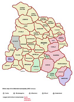
Aside from the town of Medveđa, the municipality includes the following settlements:
- Bogunovac
- Borovac
- Varadin
- Velika Braina
- Vrapce
- Gazdare
- Gornja Lapaštica
- Gornji Bučumet
- Gornji Gajtan
- Grbavce
- Gubavce
- Gurgutovo
- Donji Bučumet
- Donji Gajtan
- Đulekare
- Kapit
- Lece
- Mala Braina
- Marovac
- Maćedonce
- Maćedonce (Retkocersko)
- Medevce
- Mrkonje
- Negosavlje
- Petrilje
- Poroštica
- Pusto Šilovo
- Ravna Banja
- Retkocer
- Rujkovac
- Svirce
- Sijarina
- Sijarinska Banja
- Sponce
- Srednji Bučumet
- Stara Banja
- Stubla
- Tulare
- Tupale
- Crni Vrh
- Čokotin
الديمغرافيا
| Year | Pop. | ±% p.a. |
|---|---|---|
| 1948 | 22٬478 | — |
| 1953 | 24٬300 | +1.57% |
| 1961 | 24٬244 | −0.03% |
| 1971 | 20٬792 | −1.52% |
| 1981 | 17٬219 | −1.87% |
| 1991 | 13٬368 | −2.50% |
| 2002 | 10٬760 | −1.95% |
| 2011 | 7٬438 | −4.02% |
| Source: [20] | ||
According to the 2011 census results, the municipality of Medveđa has a population of 7,438 inhabitants. It saw a great depopulation in the past 50 years, having nearly 25,000 inhabitants in 1961 and 7,400 fifty years later. Around 43.5% of inhabitants live in urban areas.
الجماعات العرقية
The majority of municipality's population are Serbs, numbering more than 65%. Other ethnic groups include Albanians who numbered 32% in 1981 and 26.2% in 2002 census. In 2011 they numbered only 7.1%. This was partially because of the boycott of Albanians in Serbia and from the economic or security situation in the 1990s and 2000s.[بحاجة لمصدر]
There are other small minorities of Montenegrins and غجر. The ethnic composition of the municipality:
| Ethnic group | Population 1961[21] |
Population 1971[22] |
Population 1981[23] |
Population 1991[24] |
Population 2002[25] |
أخفPopulation 2011[26] |
|---|---|---|---|---|---|---|
| صرب | 18,956 | 13,002 | 9,654 | 8,194 | 7,163 | 6,429 |
| ألبان | 5,037 | 5,410 | 5,509 | 3,832 | 2,816 | 527 |
| Montenegrins | 110 | 2,127 | 1,700 | 1,011 | 372 | 143 |
| Romani | 36 | 52 | 83 | 119 | 108 | 145 |
| Macedonians | 6 | 14 | 17 | - | 11 | 13 |
| Muslims | 61 | 19 | 56 | 16 | 4 | 4 |
| Bulgarians | - | - | - | - | 5 | 4 |
| Yugoslavs | 1 | 68 | 145 | 67 | 2 | - |
| غيرهم | 37 | 100 | 55 | 129 | 279 | 173 |
| الإجمالي | 24,244 | 20,792 | 17,219 | 13,368 | 10,760 | 7,438 |
الاقتصاد
The municipality of Medveđa is one of the least developed municipalities in Serbia. It has many natural advantages for tourism development, as it is in the vicinity of a spa resort with dozens of mineral springs in Sijarinska Banja, ستارا بانيا و تولارى.
On its territory there are mineral resources for mining, semi-precious stones and marble-onyx. The most promising branch of industry is mining, having mine and flotation "Lece", within the Group Farmakom. It has also solid prospects for development in agriculture and industries such as livestock (sheep, goats, cows) and fruit (plums, pears, apples, quince), also the timber industry and processing.
The following table gives a preview of total number of registered people employed in legal entities per their core activity (as of 2018):[27]
| Activity | Total |
|---|---|
| Agriculture, forestry and fishing | 30 |
| Mining and quarrying | 398 |
| Manufacturing | 42 |
| Electricity, gas, steam and air conditioning supply | 10 |
| Water supply; sewerage, waste management and remediation activities | 48 |
| Construction | 28 |
| Wholesale and retail trade, repair of motor vehicles and motorcycles | 135 |
| Transportation and storage | 30 |
| Accommodation and food services | 35 |
| Information and communication | 3 |
| Financial and insurance activities | 3 |
| Real estate activities | 3 |
| Professional, scientific and technical activities | 20 |
| Administrative and support service activities | 2 |
| Public administration and defense; compulsory social security | 326 |
| Education | 222 |
| Human health and social work activities | 229 |
| Arts, entertainment and recreation | 17 |
| Other service activities | 9 |
| Individual agricultural workers | 230 |
| Total | 1,820 |
السياسة
Seats in the municipality parliament won in the 2012 local elections:[28]
- Group of Citizens "For North Jablanica" (16)
- Party for Democratic Action (6)
- Democratic Party (6)
- United Regions of Serbia (4)
- Serbian Progressive Party (3)
معرض صور
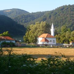
Svirce in 2017
أشخاص بارزون
- Idriz Ajeti, Albanian historian
- Astrit Ajdarević, Albanian-Swedish football player
- Dušan Spasojević, deceased head of the Zemun clan
الهامش
- ^ قالب:Serbian municipalities 2006
- ^ "Насеља општине Медвеђа" (PDF). stat.gov.rs (in الصربية). Statistical Office of Serbia. Retrieved 22 October 2019.
- ^ قالب:Serbian census 2011
- ^ https://web.archive.org/web/20111006073900/http://www.narodnimuzej.rs/code/navigate.php?Id=147. Archived from the original on 2011-10-06.
{{cite web}}: Missing or empty|title=(help) - ^ Uka, Sabit (2004). Jeta dhe veprimtaria e shqiptarëve të Sanxhakut të Nishit deri më 1912 [Life and activity of Albanians in the Sanjak of Nish up to 1912]. Verana. pp. 244–245. ISBN 9789951864527. "Eshtë, po ashtu, me peshë historike një shënim i M. Gj Miliçeviqit, i cili bën fjalë përkitazi me Ivan Begun. Ivan Begu, sipas tij ishte pjesëmarrës në Luftën e Kosovës 1389. Në mbështetje të vendbanimit të tij, Ivan Kullës, fshati emërtohet Ivan Kulla (Kulla e Ivanit), që gjendet në mes të Kurshumlisë dhe Prokuplës. M. Gj. Miliçeviqi thotë: "Shqiptarët e ruajten fshatin Ivan Kullë (1877–1878) dhe nuk lejuan që të shkatërrohet ajo". Ata, shqiptaret e Ivan Kullës (1877–1878) i thanë M. Gj. Miliçeviqit se janë aty që nga para Luftës se Kosovës (1389). [12] Dhe treguan që trupat e arrave, që ndodhen aty, ata i pat mbjellë Ivan beu. Atypari, në malin Gjakë, nodhet kështjella që i shërbeu Ivanit (Gjonit) dhe shqiptarëve për t’u mbrojtur. Aty ka pasur gjurma jo vetëm nga shekulli XIII dhe XIV, por edhe të shekullit XV ku vërehen gjurmat mjaft të shumta toponimike si fshati Arbanashka, lumi Arbanashka, mali Arbanashka, fshati Gjakë, mali Gjakë e tjerë. [13] Në shekullin XVI përmendet lagja shqiptare Pllanë jo larg Prokuplës. [14] Ne këtë shekull përmenden edhe shqiptarët katolike në qytetin Prokuplë, në Nish, në Prishtinë dhe në Bulgari.[15].... [12] M. Đj. Miličević. Kralevina Srbije, Novi Krajevi. Beograd, 1884: 354. "Kur flet mbi fshatin Ivankullë cekë se banorët shqiptarë ndodheshin aty prej Betejës së Kosovës 1389. Banorët e Ivankullës në krye me Ivan Begun jetojnë aty prej shek. XIV dhe janë me origjinë shqiptare. Shqiptarët u takojnë të tri konfesioneve, por shumica e tyre i takojnë atij musliman, mandej ortodoks dhe një pakicë i përket konfesionit katolik." [13] Oblast Brankovića, Opširni katastarski popis iz 1455 godine, përgatitur nga M. Handžic, H. Hadžibegić i E. Kovačević, Sarajevo, 1972: 216. [14] Skënder Rizaj, T,K "Perparimi" i vitit XIX, Prishtinë 1973: 57.[15] Jovan M. Tomić, O Arnautima u Srbiji, Beograd, 1913: 13. [It is, as such, of historic weight in a footnote of M. Đj. Miličević, who says a few words regarding Ivan Beg. Ivan Beg, according to him participated in the Battle of Kosovo in 1389. In support of his residence, Ivan Kula, the village was named Ivan Kula (Tower of Ivan), located in the middle of Kuršumlija and Prokuple. M. Đj. Miličević says: "Albanians safeguarded the village Ivan Kula (1877–1878) and did not permit its destruction." Those Albanians of Ivan Kulla (1877–1878) told M.Đj. Miličević that they have been there since before the Kosovo War (1389). And they showed where the bodies of the walnut trees were, that Ivan Bey had planted. Then there to Mount Đjake, is the castle that served Ivan (John) and Albanians used to defend themselves. There were traces not only from the XIII and XIV centuries, but the XV century where we see fairly multiple toponymic traces like the village Arbanaška, river Arbanaška, mountain Arbanaška, village Đjake, mountain Đjake and others. In the sixteenth century mentioned is the Albanian neighborhood Plana not far from Prokuple. [14] In this century is mentioned also Catholic Albanians in the town of Prokuplje, Niš, Priština and in Bulgaria.[15].... [12] M. Đj. Miličević. Kralevina Srbije, Novi Krajevi. Beograd, 1884: 354. When speaking about the village Ivankula, its residents state that Albanians were there from the Battle of Kosovo in 1389. Residents of Ivankula headed by Ivan Beg are living there since the XIV century and they are of Albanian origin. Albanians belong to three religions, but most of them belong to the Muslim one, after Orthodoxy and then a minority belongs to the Catholic confession. [13] Oblast Brankovića, Opširni katastarski popis iz 1455 godine, përgatitur nga M. Handžic, H. Hadžibegić i E. Kovačević, Sarajevo, 1972: 216. [14] Skënder Rizaj, T,K "Perparimi" i vitit XIX, Prishtinë 1973: 57. [15] Jovan M. Tomić, O Arnautima u Srbiji, Beograd, 1913: 13.]"
- ^ Geniş, Şerife; Maynard, Kelly Lynne (2009). "Formation of a Diasporic Community: The History of Migration and Resettlement of Muslim Albanians in the Black Sea Region of Turkey: Middle Eastern Studies: Vol 45, No 4". Middle Eastern Studies. 45 (4): 556–557. doi:10.1080/00263200903009619. S2CID 143742189.
Using secondary sources, we establish that there have been Albanians living in the area of Nish for at least 500 years, that the Ottoman Empire controlled the area from the fourteenth to nineteenth centuries which led to many Albanians converting to Islam, that the Muslim Albanians of Nish were forced to leave in 1878, and that at that time most of these Nishan Albanians migrated south into Kosovo, although some went to Skopje in Macedonia. ; p. 557. It is generally believed that the Albanians in Samsun Province are the descendants of the migrants and refugees from Kosovo who arrived in Turkey during the wars of 1912–13. Based on our research in Samsun Province, we argue that this information is partial and misleading. The interviews we conducted with the Albanian families and community leaders in the region and the review of Ottoman history show that part of the Albanian community in Samsun was founded through three stages of successive migrations. The first migration involved the forced removal of Muslim Albanians from the Sancak of Nish in 1878; the second migration occurred when these migrants' children fled from the massacres in Kosovo in 1912–13 to Anatolia; and the third migration took place between 1913 and 1924 from the scattered villages in Central Anatolia where they were originally placed to the Samsun area in the Black Sea Region. Thus, the Albanian community founded in the 1920s in Samsun was in many ways a reassembling of the demolished Muslim Albanian community of Nish…. Our interviews indicate that Samsun Albanians descend from Albanians who had been living in the villages around the city of Nish… pp. 557–558. In 1690 much of the population of the city and surrounding area was killed or fled, and there was an emigration of Albanians from the Malësia e Madhe (North Central Albania/Eastern Montenegro) and Dukagjin Plateau (Western Kosovo) into Nish.
- ^ Jagodić 1998, para. 4, 9, 32–42, 45–61.
- ^ Luković, Miloš (2011). "Development of the Modern Serbian state and abolishment of Ottoman Agrarian relations in the 19th century". Český lid. 98. (3): 298. "During the second war (December 1877 — January 1878) the Muslim population fled towns (Vranya (Vranje), Leskovac, Ürgüp (Prokuplje), Niş (Niš), Şehirköy (Pirot), etc.) as well as rural settlements where they comprised ethnically compact communities (certain parts of Toplica, Jablanica, Pusta Reka, Masurica and other regions in the South Morava River basin). At the end of the war these Muslim refugees ended up in the region of Kosovo and Metohija, in the territory of the Ottoman Empire, following the demarcation of the new border with the Principality of Serbia. [38] [38] On Muslim refugees (muhaciri) from the regions of southeast Serbia, who relocated in Macedonia and Kosovo, see Trifunovski 1978, Radovanovič 2000."
- ^ Bataković, Dušan T. (2007). Kosovo and Metohija: living in the enclave. Serbian Academy of Sciences and Arts, Institute for Balkan Studies. p. 35. Retrieved 22 June 2011. "Prior to the Second Serbo-Ottoman War (1877-78), Albanians were the majority population in some areas of Sanjak of Nis (Toplica region), while from the Serb majority district of Vranje Albanian-inhabited villages were emptied after the 1877-1878 war"
- ^ أ ب ت Turović, Dobrosav (2002). Gornja Jablanica, Kroz istoriju. Beograd Zavičajno udruženje. pp. 87–89.
- ^ أ ب Uka, Sabit (2004). Gjurmë mbi shqiptarët e Sanxhakut të Nishit deri më 1912 [Traces on Albanians of the Sanjak of Nish up to 1912]. Verana. p. 155. ISBN 9789951864527. "Në kohët e sotme fshatra të Jabllanicës, të banuara kryesisht me shqiptare, janë këto: Tupalla, Kapiti, Gërbavci, Sfirca, Llapashtica e Epërrne. Ndërkaq, fshatra me popullsi te përzier me shqiptar, malazezë dhe serbë, jane këto: Stara Banja, Ramabanja, Banja e Sjarinës, Gjylekreshta (Gjylekari), Sijarina dhe qendra komunale Medvegja. Dy familje shqiptare ndeshen edhe në Iagjen e Marovicës, e quajtur Sinanovë, si dhe disa familje në vetë qendrën e Leskovcit. Vllasa është zyrtarisht lagje e fshatit Gërbavc, Dediqi, është lagje e Medvegjes dhe Dukati, lagje e Sijarinës. Në popull konsiderohen edhe si vendbanime të veçanta. Kështu qendron gjendja demografike e trevës në fjalë, përndryshe para Luftës se Dytë Botërore Sijarina dhe Gjylekari ishin fshatra me populisi të perzier, bile në këtë te fundit ishin shumë familje serbe, kurse tani shumicën e përbëjnë shqiptarët. [In contemporary times, villages in the Jablanica area, inhabited mainly by Albanians, are these: Tupale, Kapiti, Grbavce, Svirca, Gornje Lapaštica. Meanwhile, the mixed villages populated by Albanians, Montenegrins and Serbs, are these: Stara Banja, Ravna Banja, Sjarinska Banja, Đulekrešta (Đulekari) Sijarina and the municipal center Medveđa. Two Albanian families are also encountered in the neighborhood of Marovica called Sinanovo, and some families in the center of Leskovac. Vllasa is formally a neighborhood of the village Grbavce, Dedići is a neighborhood of Medveđa and Dukati, a neighborhood of Sijarina. So this is the demographic situation in question that remains, somewhat different before World War II as Sijarina and Đulekari were villages with mixed populations, even in this latter settlement were many Serb families, and now the majority is made up of Albanians.]"
- ^ أ ب ت Blumi, Isa (2013). Ottoman refugees, 1878–1939: migration in a post-imperial world. A&C Black. p.50. ISBN 9781472515384. "As these Niš refugees waited for acknowledgment from locals, they took measures to ensure that they were properly accommodated by often confiscating food stored in towns. They also simply appropriated lands and began to build shelter on them. A number of cases also point to banditry in the form of livestock raiding and "illegal" hunting in communal forests, all parts of refugees’ repertoire... At this early stage of the crisis, such actions overwhelmed the Ottoman state, with the institution least capable of addressing these issues being the newly created Muhacirin Müdüriyeti... Ignored in the scholarship, these acts of survival by desperate refugees constituted a serious threat to the established Kosovar communities. The leaders of these communities thus spent considerable efforts lobbying the Sultan to do something about the refugees. While these Niš muhacir would in some ways integrate into the larger regional context, as evidenced later, they, and a number of other Albanian-speaking refugees streaming in for the next 20 years from Montenegro and Serbia, constituted a strong opposition block to the Sultan’s rule."; p.53. "One can observe that in strategically important areas, the new Serbian state purposefully left the old Ottoman laws intact. More important, when the state wished to enforce its authority, officials felt it necessary to seek the assistance of those with some experience, using the old Ottoman administrative codes to assist judges make rulings. There still remained, however, the problem of the region being largely depopulated as a consequence of the wars... Belgrade needed these people, mostly the landowners of the productive farmlands surrounding these towns, back. In subsequent attempts to lure these economically vital people back, while paying lip-service to the nationalist calls for "purification," Belgrade officials adopted a compromise position that satisfied both economic rationalists who argued that Serbia needed these people and those who wanted to separate "Albanians" from "Serbs." Instead of returning back to their "mixed" villages and towns of the previous Ottoman era, these "Albanians," "Pomoks," and "Turks" were encouraged to move into concentrated clusters of villages in Masurica, and Gornja Jablanica that the Serbian state set up for them. For this "repatriation" to work, however, authorities needed the cooperation of local leaders to help persuade members of their community who were refugees in Ottoman territories to "return." In this regard, the collaboration between Shahid Pasha and the Serbian regime stands out. An Albanian who commanded the Sofia barracks during the war, Shahid Pasha negotiated directly with the future king of Serbia, Prince Milan Obrenović, to secure the safety of those returnees who would settle in the many villages of Gornja Jablanica. To help facilitate such collaborative ventures, laws were needed that would guarantee the safety of these communities likely to be targeted by the rising nationalist elements infiltrating the Serbian army at the time. Indeed, throughout the 1880s, efforts were made to regulate the interaction between exiled Muslim landowners and those local and newly immigrant farmers working their lands. Furthermore, laws passed in early 1880 began a process of managing the resettlement of the region that accommodated those refugees who came from Austrian-controlled Herzegovina and from Bulgaria. Cooperation, in other words, was the preferred form of exchange within the borderland, not violent confrontation."
- ^ Müller, Dietmar (2009). "Orientalism and Nation: Jews and Muslims as Alterity in Southeastern Europe in the Age of Nation-States, 1878–1941". East Central Europe. 36: 63–99. doi:10.1163/187633009x411485.
- ^ Danilo Kocić (28 August 2019). Највећи проблем Медвеђе су путеви [Medveđa's main problem are roads]. Politika (in الصربية). p. 14.
- ^ Hart, Stephan. "Partisans: War in the Balkans 1941 - 1945". BBC.
- ^ European Centre for Minority Issues Staf (1 January 2003). European Yearbook of Minority Issues: 2001/2. Martinus Nijhoff Publishers. pp. 652–. ISBN 978-90-411-1956-8.
- ^ Lobjakas, Ahto. "NATO: Yugoslav Officials Discuss Presevo Valley". rferl.org. Radio Free Europe / Liberty. Retrieved 22 April 2017.
- ^ "Otvorena baza na jugu Srbije". b92.net (in الصربية). Beta. 23 November 2009. Retrieved 6 March 2017.
- ^ Mitić, I. (26 November 2017). "Ilir Meta u Medveđi: Posetom šalje poruku o saradnji". novosti.rs (in الصربية). Retrieved 27 November 2017.
- ^ "2011 Census of Population, Households and Dwellings in the Republic of Serbia" (PDF). stat.gov.rs. Statistical Office of the Republic of Serbia. Archived from the original (PDF) on 14 July 2014. Retrieved 12 January 2017.
- ^ "Knjiga III: Nacionalni sastav stanovništva FNR Jugoslavije (1961)" (PDF). stat.gov.rs (in الصربية). Republički zavod za statistiku. Archived from the original (PDF) on 20 December 2013. Retrieved 3 March 2015.
- ^ "Knjiga III: Nacionalni sastav stanovništva FNR Jugoslavije (1971)" (PDF). stat.gov.rs (in الصربية). Republički zavod za statistiku. Archived from the original (PDF) on 4 March 2016. Retrieved 3 March 2015.
- ^ "Nacionalni sastav stanovništva SFR Jugoslavije (1981)" (PDF). stat.gov.rs. Republički zavod za statistiku. Archived from the original (PDF) on 4 March 2016. Retrieved 3 March 2015.
- ^ "STANOVNIŠTVO PREMA NACIONALNOJ PRIPADNOSTI (1991)" (PDF). stat.gov.rs. Republički zavod za statistiku. Archived from the original (PDF) on 4 March 2016. Retrieved 3 March 2015.
- ^ "Popis stanovnistva, domacinstava i stanova u 2002" (PDF). stat.gov.rs (in الصربية). Archived from the original (PDF) on 14 October 2013. Retrieved 3 March 2015.
- ^ "Попис становништва, домаћинстава и станова 2011. у Републици Србији" (PDF). stat.gov.rs. Republički zavod za statistiku. Archived from the original (PDF) on 11 August 2014. Retrieved 3 March 2015.
- ^ "MUNICIPALITIES AND REGIONS OF THE REPUBLIC OF SERBIA, 2019" (PDF). stat.gov.rs. Statistical Office of the Republic of Serbia. 25 December 2019. Retrieved 29 December 2019.
- ^ Kocić, Danilo (26 June 2012). "Konačni rezultati izbora u Medveđi". juznevesti.com (in الصربية). Retrieved 2 June 2015.
وصلات خارجية
- Pages using gadget WikiMiniAtlas
- CS1 الصربية-language sources (sr)
- CS1 errors: missing title
- CS1 errors: bare URL
- CS1 uses الصربية-language script (sr)
- Short description is different from Wikidata
- Coordinates on Wikidata
- Articles containing صربية-language text
- Articles containing ألبانية-language text
- Pages using Lang-xx templates
- مقالات ذات عبارات بحاجة لمصادر
- مدڤدزا
- Populated places in Jablanica District
- بلديات ومدن جنوب وشرق صربيا
- Albanian communities in Serbia
