المطلة
المطلة
| |
|---|---|
| الترجمة اللفظية بالـ العبرية | |
| • ISO 259 | Mṭulla |
| • ويُكتب أيضاً | Metulla (غير رسمي) |
 | |
 المطلة | |
| الإحداثيات: 33°16′44″N 35°34′28″E / 33.27889°N 35.57444°E | |
| تأسست | 1896 |
| الحكومة | |
| • النوع | المجلس المحلي |
| • رأس البلدية | هرتسل بكر |
| المساحة | |
| • الإجمالي | 9٫413 كم² (3٫634 ميل²) |
| التعداد (2019)[1] | |
| • الإجمالي | 1٬615 |
| معنى الاسم | “المنظر الجميل”[2] |
| الموقع الإلكتروني | http://www.metulla.muni.il/ |

المطلة (بالعبرية: מְטֻלָּה)، هي بلدة في المنطقة الشمالية، إسرائيل. تقع المطلة بين ثلاث مواقع ذُكرت في الكتاب المقدس، دان وأبل بيت معاخا وإيون، وتقع على الحدود اللبنانية. حسب 2019 كان عدد سكانها 1,615 نسمة.
كانت المطلة بلدة فلسطينية أقيمت على أراضيها مستوطنة ميتولا عام 1896 على أيدي مهاجرين صهاينة أتوا من روسيا. تبلغ مساحتها 9.413 دونم. تعرف المستوطنة بأنها مدينة ثرية وتشتهر كوجهة سياحية خاصة بالنسبة لتلاميذ المدارس خلال العطلة الصيفية.[3] أصبحت المستوطنة مدينة أشباح مؤقتاً خلال حرب لبنان 2006 بعد أن هجرها سكانها هرباً من نيران صواريخ حزب الله. تعرضت البلدة للقصف بـ120 صاروخ خلال الحرب.[3]
التاريخ
التاريخ المبكر
الفترة العثمانية
تأسيس الموشاڤا اليهودي
فترة الانتداب

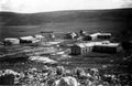
معسكر بريطاني في المطلة عام 1948
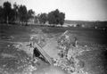
جسر المطلة بعد قصفه، 15 فبراير 1948.
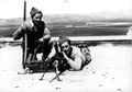
أعضاء Yiftach Brigade في المطلة، 1948.
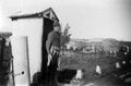
معسكر المطلة عام 1948.


قيام دولة إسرائيل

بعد انشاء إسرائيل عُرفت المطلة كبلدة ثرية مشهورة ووجهة سياحية، خاصة لأطفال المدارس الذين يقضون إجازة الصيف.[3]
هجوم 1985
أثناء صراع جنوب لبنان (1985–2000). وفي يوم 10 مارس 1985، كانت قافلة من جنود الجيش الإسرائيلي في شاحنات من طراز "سفاري" تنطلق من المطلة باتجاه بلدة مرجعيون اللبنانية. وكان العشرات من الجنود، الذين حضروا للتو من عطلة يوم السبت، في طريق إلى الخدمة. ووفقاً للأنظمة، قادر الرتل سيارة جيب مسلحة واحدة في المقدمة واثنتان في الخلف، كما ارتدى العناصر الخوذات والسترات الواقية من الرصاص. وبينما كانوا يعبرون الجسر الضيق فوق نهر عيون في الساعة 13:45، اقتربت منهم شاحنة بيك اب حمراء من طراز شيفروليه. ولاحظ جنود الجيب الأول أن السائق كان يبتسم ابتسامة ودية، وتمت الإشارة إليه بالتوقف للسماح للقافلة بالمرور. وفعل ذلك مع أول سيارة جيب وأول شاحنة سفاري، لكن تمام الساعة 13:50 فجر سائق سيارة شيفروليه انفجارا هائلا أدى إلى تحطيم النوافذ في المطلة نفسها، قُتل فيع اثنا عشر جنديًا وجُرح 14.[4]
حرب لبنان 2006
أثناء حرب لبنان 2006، أصبحت المطلة "مدينة أشباح" بعدما فر سكانها من صواريخ حزب الله. وأصيبت بـحوالي 120 صاروخاً خلال الحرب.[3]
الحرب الإسرائيلية الفلسطينية
خلال الحرب الإسرائيلية الفلسطينية، استهدف حزب الله المواقع العسكرية الإسرائيلية الحدودية بالصواريخ والقذائف، مما أدى إلى إخلاء العديد منها، بما في ذلك المطلة. وفي 17 أكتوبر، ضرب صاروخ مضاد للدبابات أطلقه حزب الله المطلة، مما أدى إلى إصابة اثنين من جنود الاحتياط في جيش الدفاع الإسرائيلي.[5]
وفي 19 ديسمبر، أطلق حزب الله عدداً من قذائف المدفعية على المطلة.[6]
عزو اسرائيل للبنان 2024
في 30 سبتمبر 2024، بدأ الجيش الإسرائيلي غزو بري على جنوب لبنان. وفي اليوم نفسه، أعلن جيش الدفاع الإسرائيلي أن المطلة أصبحت منطقة عسكرية مغلقة.[7]

الجغرافيا
السكان

- 1948 - 172
- 1961 - 261
- 1972 - 333
- 1983 - 589
- 1995 - 942
- 2003 - 1400
مشاهير المطلة
- أولگا دانيلوڤ (و. 1973)، متزلج أولمپي إسرائيلي
- ألكسندرا زارتسكي (و. 1987)، راقصة إسرائيلية على الجليد
- رومان زارتسكي (و. 1983)، راقصة إسرائيلية على الجليد
الهوامش
- ^ "Population in the Localities 2019" (XLS). Israel Central Bureau of Statistics. Retrieved 16 August 2020.
- ^ Palmer, 1881, p. 30
- ^ أ ب ت ث Calm Returns to Israeli Border Town Two Years After War خطأ استشهاد: وسم
<ref>غير صالح؛ الاسم "voa" معرف أكثر من مرة بمحتويات مختلفة. - ^ "Israel in Mourning as 12 Killed in Suicide-truck Bombing Are Buried". 12 March 1985.
- ^ Fabian, Emanuel. "Metula missile attack injures 3; IDF kills Hezbollah cell trying to infiltrate border". www.timesofisrael.com (in الإنجليزية الأمريكية). Retrieved 2023-10-22.
- ^ الدهيبي, جنى. "هل ينجح الغرب في سحب حزب الله من جنوب الليطاني؟". الجزيرة نت. Retrieved 2023-12-20.
- ^ "Metula, Misgav Am, Kfar Giladi in Israel's North declared closed military zones". jpost.com (in الإنجليزية). Retrieved 2024-09-30.
المراجع
- Alexandre, Yardenna (2008-12-30). "Metulla Final Report" (121). Hadashot Arkheologiyot – Excavations and Surveys in Israel.
{{cite journal}}: Cite journal requires|journal=(help) - Avneri, Arieh L. (1984). The Claim of Dispossession: Jewish Land-settlement and the Arabs, 1878-1948. Transaction Publishers. ISBN 0-87855-964-7.
- Bentwich, Norman (1919). Palestine of the Jews: past, present and future. London: K. Paul, Trench, Trubner.
- Biger, Gideon (2004). The boundaries of modern Palestine, 1840-1947. Routledge. ISBN 978-0-7146-5654-0.
- Buckingham, J. S. (1825). Travels among the Arab Tribes inhabiting the countries east of Syria and Palestine…. London: Longman, Hurst, Rees, Orme, Brown and Green.
- Conder, Claude Reignier; Kitchener, H. H. (1881). The Survey of Western Palestine: Memoirs of the Topography, Orography, Hydrography, and Archaeology. Vol. 1. London: Committee of the Palestine Exploration Fund.
- Dauphin, Claudine (1998). La Palestine byzantine, Peuplement et Populations. BAR International Series 726 (in French). Vol. III : Catalogue. Oxford: Archeopress. ISBN 0-860549-05-4.
{{cite book}}: CS1 maint: unrecognized language (link) - Guérin, Victor (1880). Description Géographique Historique et Archéologique de la Palestine (in French). Vol. 3: Galilee, pt. 2. Paris: L'Imprimerie Nationale.
{{cite book}}: CS1 maint: unrecognized language (link) - Hadawi, Sami (1970). Village Statistics of 1945: A Classification of Land and Area ownership in Palestine. Palestine Liberation Organization Research Center.
- Jaffe, Gilad Bezal’el (2010-02-28). "Metulla Final Report" (122). Hadashot Arkheologiyot – Excavations and Surveys in Israel.
{{cite journal}}: Cite journal requires|journal=(help) - Mills, E., ed. (1932). Census of Palestine 1931. Population of Villages, Towns and Administrative Areas. Jerusalem: Government of Palestine.
- Morris, Benny (2001). Righteous Victims. Vintage. ISBN 0-679-42120-3.
- Palmer, E. H. (1881). The Survey of Western Palestine: Arabic and English Name Lists Collected During the Survey by Lieutenants Conder and Kitchener, R. E. Transliterated and Explained by E.H. Palmer. Committee of the Palestine Exploration Fund.
وصلات خارجية
- Metula municipality
- Places To Visit in Metula (English)
- Canada Centre
- Israel Nature and National Parks Protection Authority, Eng+Heb
- Survey of Western Palestine, Map 2: IAA, Wikimedia commons
- Pages using gadget WikiMiniAtlas
- CS1 الإنجليزية الأمريكية-language sources (en-us)
- Short description is different from Wikidata
- Articles containing عبرية-language text
- Articles containing explicitly cited عربية-language text
- Coordinates on Wikidata
- المنطقة الشمالية (إسرائيل)
- قرى جبل عامل
- قضاء صفد
- مجالس محلية في المنطقة الشمالية (إسرائيل)
- مجالس محلية في إسرائيل
- مستعمرات
- مستوطنات إسرائيلية